Lesley Topo Map Texas
To zoom in, hover over the map of Lesley
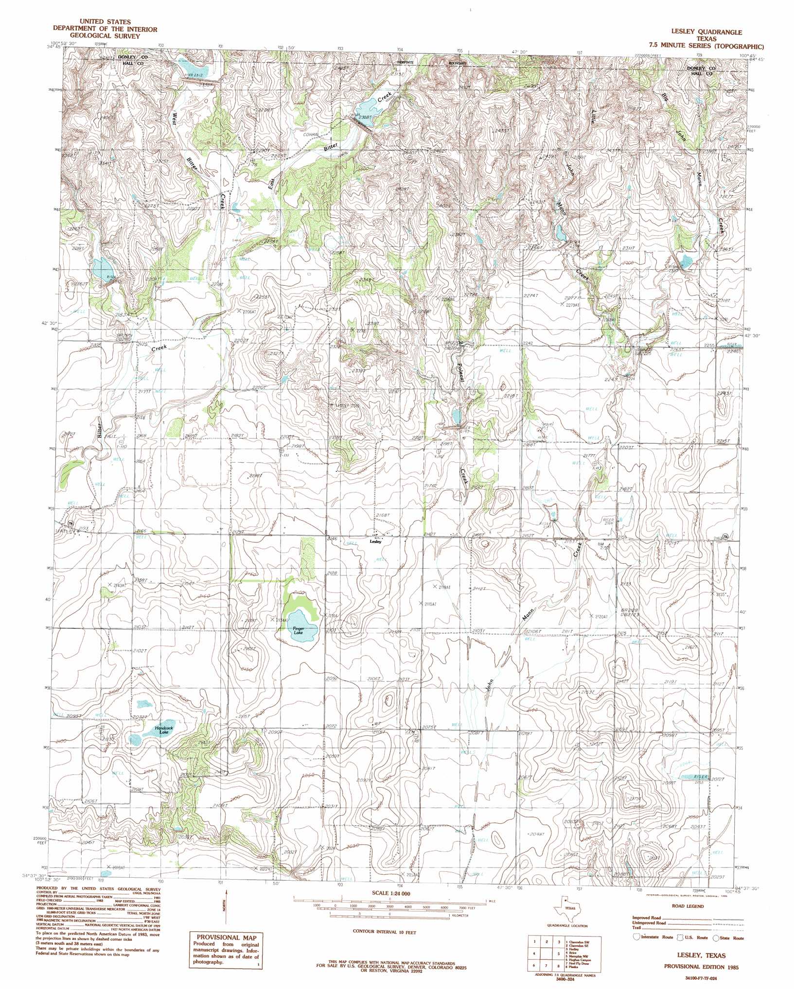
USGS Topo Quad 34100f7 - 1:24,000 scale
| Topo Map Name: | Lesley |
| USGS Topo Quad ID: | 34100f7 |
| Print Size: | ca. 21 1/4" wide x 27" high |
| Southeast Coordinates: | 34.625° N latitude / 100.75° W longitude |
| Map Center Coordinates: | 34.6875° N latitude / 100.8125° W longitude |
| U.S. State: | TX |
| Filename: | o34100f7.jpg |
| Download Map JPG Image: | Lesley topo map 1:24,000 scale |
| Map Type: | Topographic |
| Topo Series: | 7.5´ |
| Map Scale: | 1:24,000 |
| Source of Map Images: | United States Geological Survey (USGS) |
| Alternate Map Versions: |
Brice NE TX 1976, updated 1978 Download PDF Buy paper map Lesley TX 1985, updated 1985 Download PDF Buy paper map Lesley TX 2010 Download PDF Buy paper map Lesley TX 2013 Download PDF Buy paper map Lesley TX 2016 Download PDF Buy paper map |
1:24,000 Topo Quads surrounding Lesley
Buffalo Arroyo |
Clarendon |
Lelia Lake |
Lelia Lake Creek |
Mcknight |
Tate Arroyo |
Clarendon Sw |
Clarendon Se |
Hedley |
Giles |
Willow Arroyo |
Brice |
Lesley |
Memphis Nw |
Memphis |
Schott Mountain |
Hughes Canyon |
Heel Fly Draw |
Plaska |
Parnell |
Lake Theo |
Turkey |
Tampico Siding |
Blue Tank Canyon |
Badger Nest Tank |
> Back to 34100e1 at 1:100,000 scale
> Back to 34100a1 at 1:250,000 scale
> Back to U.S. Topo Maps home
Lesley topo map: Gazetteer
Lesley: Dams
Soil Conservation Service Site 107 Dam elevation 628m 2060′Soil Conservation Service Site 3 Dam elevation 672m 2204′
Soil Conservation Service Site 4 Dam elevation 694m 2276′
Soil Conservation Service Site 5 Dam elevation 703m 2306′
Soil Conservation Service Site 6 Dam elevation 665m 2181′
Soil Conservation Service Site 7 Dam elevation 702m 2303′
Soil Conservation Service Site 8 Dam elevation 701m 2299′
Soil Conservation Service Site Number 101 Dam elevation 665m 2181′
Soil Conservation Service Site Number 102 Dam elevation 659m 2162′
Soil Conservation Service Site Number 103 Dam elevation 673m 2208′
Lesley: Lakes
Finger Lake elevation 638m 2093′Hancock Lake elevation 626m 2053′
Lesley: Populated Places
Lesley elevation 661m 2168′Lesley: Reservoirs
Soil Conservation Service Site 101 Reservoir elevation 665m 2181′Soil Conservation Service Site 107 Reservoir elevation 628m 2060′
Soil Conservation Service Site 3 Reservoir elevation 672m 2204′
Soil Conservation Service Site 4 Reservoir elevation 694m 2276′
Soil Conservation Service Site 5 Reservoir elevation 703m 2306′
Soil Conservation Service Site 6 Reservoir elevation 665m 2181′
Soil Conservation Service Site 7 Reservoir elevation 702m 2303′
Soil Conservation Service Site 8 Reservoir elevation 701m 2299′
Soil Conservation Service Site Number 102 Reservoir elevation 659m 2162′
Soil Conservation Service Site Number 103 Reservoir elevation 673m 2208′
Lesley: Streams
Big John Mann Creek elevation 674m 2211′East Bitter Creek elevation 672m 2204′
Little John Mann Creek elevation 673m 2208′
West Bitter Creek elevation 672m 2204′
Lesley digital topo map on disk
Buy this Lesley topo map showing relief, roads, GPS coordinates and other geographical features, as a high-resolution digital map file on DVD: