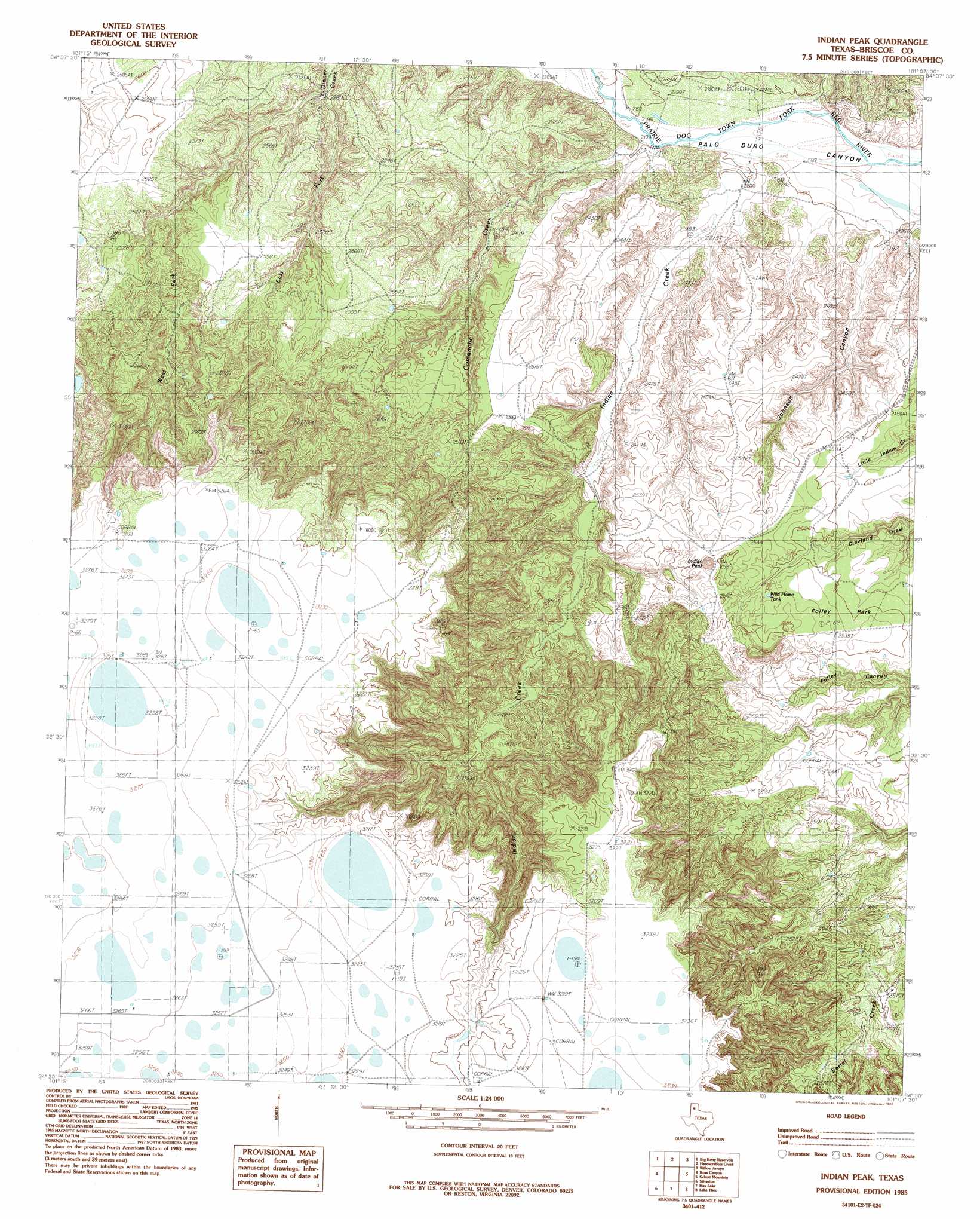
Indian Peak Topo Map Texas
To zoom in, hover over the map of Indian Peak
USGS Topo Quad 34101e2 - 1:24,000 scale
| Topo Map Name: | Indian Peak |
| USGS Topo Quad ID: | 34101e2 |
| Print Size: | ca. 21 1/4" wide x 27" high |
| Southeast Coordinates: | 34.5° N latitude / 101.125° W longitude |
| Map Center Coordinates: | 34.5625° N latitude / 101.1875° W longitude |
| U.S. State: | TX |
| Filename: | o34101e2.jpg |
| Download Map JPG Image: | Indian Peak topo map 1:24,000 scale |
| Map Type: | Topographic |
| Topo Series: | 7.5´ |
| Map Scale: | 1:24,000 |
| Source of Map Images: | United States Geological Survey (USGS) |
| Alternate Map Versions: |
Indian Peak SW TX 1976, updated 1978 Download PDF Buy paper map Indian Peak TX 1985, updated 1985 Download PDF Buy paper map Indian Peak TX 2010 Download PDF Buy paper map Indian Peak TX 2012 Download PDF Buy paper map Indian Peak TX 2016 Download PDF Buy paper map |
1:24,000 Topo Quads surrounding Indian Peak
Pleasant Creek |
Gip Creek |
Paloduro |
Tate Arroyo |
Clarendon Sw |
Vigo Peak |
Big Betty Reservoir |
Hardscrabble Creek |
Willow Arroyo |
Brice |
Cope Creek |
Ross Canyon |
Indian Peak |
Schott Mountain |
Hughes Canyon |
Rock Creek |
Silverton |
Hay Lake |
Lake Theo |
Turkey |
Silverton Sw |
Whiteley |
Edgemon Lake |
Quitaque |
Folley |
> Back to 34101e1 at 1:100,000 scale
> Back to 34100a1 at 1:250,000 scale
> Back to U.S. Topo Maps home
Indian Peak topo map: Gazetteer
Indian Peak: Flats
Folley Park elevation 765m 2509′Indian Peak: Reservoirs
Wild Horse Tank elevation 773m 2536′Indian Peak: Streams
Comanche Creek elevation 670m 2198′East Fork Dinner Creek elevation 695m 2280′
Indian Creek elevation 668m 2191′
Sand Creek elevation 665m 2181′
West Fork Dinner Creek elevation 695m 2280′
Indian Peak: Summits
Indian Peak elevation 821m 2693′Indian Peak: Valleys
Johnson Canyon elevation 670m 2198′Indian Peak digital topo map on disk
Buy this Indian Peak topo map showing relief, roads, GPS coordinates and other geographical features, as a high-resolution digital map file on DVD: