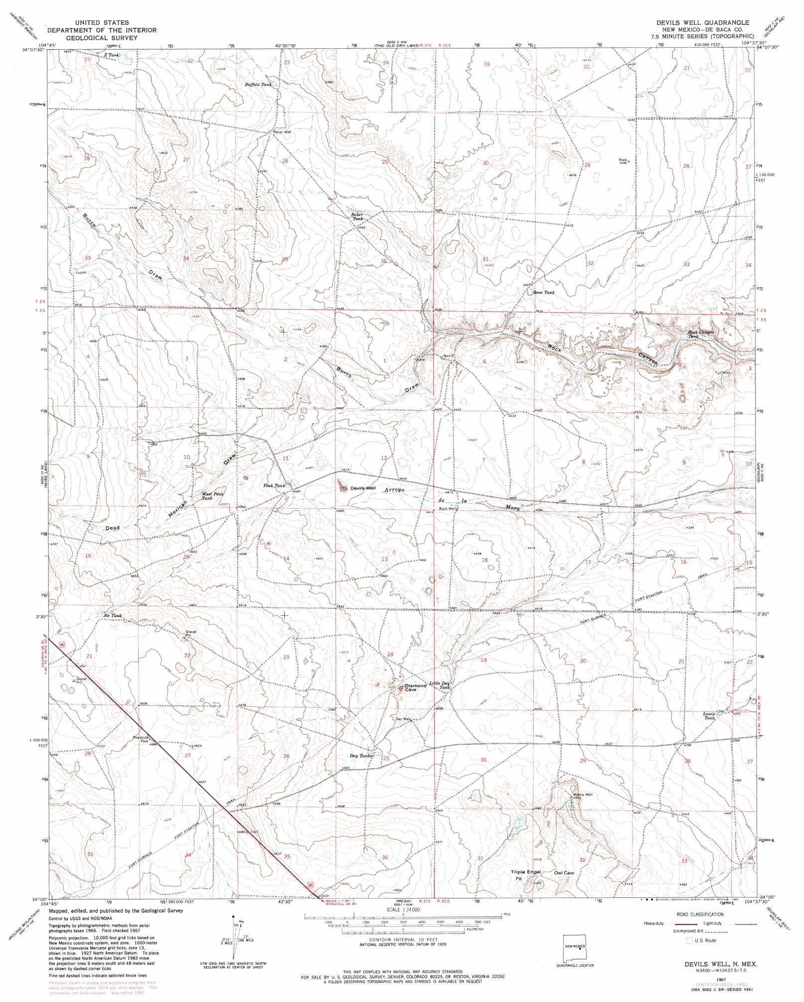
Devils Well Topo Map New Mexico
To zoom in, hover over the map of Devils Well
USGS Topo Quad 34104a6 - 1:24,000 scale
| Topo Map Name: | Devils Well |
| USGS Topo Quad ID: | 34104a6 |
| Print Size: | ca. 21 1/4" wide x 27" high |
| Southeast Coordinates: | 34° N latitude / 104.625° W longitude |
| Map Center Coordinates: | 34.0625° N latitude / 104.6875° W longitude |
| U.S. State: | NM |
| Filename: | o34104a6.jpg |
| Download Map JPG Image: | Devils Well topo map 1:24,000 scale |
| Map Type: | Topographic |
| Topo Series: | 7.5´ |
| Map Scale: | 1:24,000 |
| Source of Map Images: | United States Geological Survey (USGS) |
| Alternate Map Versions: |
Devils Well NM 1967, updated 1971 Download PDF Buy paper map Devils Well NM 1967, updated 1982 Download PDF Buy paper map Devils Well NM 2010 Download PDF Buy paper map Devils Well NM 2013 Download PDF Buy paper map Devils Well NM 2017 Download PDF Buy paper map |
1:24,000 Topo Quads surrounding Devils Well
Loco Draw |
Yeso Mesa Se |
El Morro Mesa |
Horney Ranch |
West Camp |
Ramon |
Wright Ranch |
The Old Dry Lake |
Dunlap Ne |
Conejo Creek West |
Ramon Sw |
Wire Lake |
Devils Well |
Dunlap |
Lovelady Draw |
Chivita Canyon |
Round Mountain |
Mesa |
Dunlap Sill |
Swallow Nest Canyon |
North Lake |
Round Mountain Se |
Mesa Sw |
Mesa Se |
Shannon Draw |
> Back to 34104a1 at 1:100,000 scale
> Back to 34104a1 at 1:250,000 scale
> Back to U.S. Topo Maps home
Devils Well topo map: Gazetteer
Devils Well: Basins
Devils Well elevation 1341m 4399′Triple Engle Pit elevation 1362m 4468′
Devils Well: Reservoirs
Baker Tank elevation 1354m 4442′Bone Tank elevation 1351m 4432′
Buffalo Tank elevation 1372m 4501′
Day Tanks elevation 1375m 4511′
Joe Tank elevation 1438m 4717′
Lewis Tank elevation 1333m 4373′
Little Day Tank elevation 1358m 4455′
Peak Tank elevation 1370m 4494′
Rock Canyon Tank elevation 1315m 4314′
West Peak Tank elevation 1385m 4543′
Devils Well: Trails
Old Military Road elevation 1356m 4448′Devils Well: Valleys
Burro Draw elevation 1337m 4386′Dead Mexican Draw elevation 1363m 4471′
Devils Well: Wells
Baker Well elevation 1371m 4498′Buck Well elevation 1346m 4416′
Morris Well elevation 1359m 4458′
Devils Well digital topo map on disk
Buy this Devils Well topo map showing relief, roads, GPS coordinates and other geographical features, as a high-resolution digital map file on DVD: