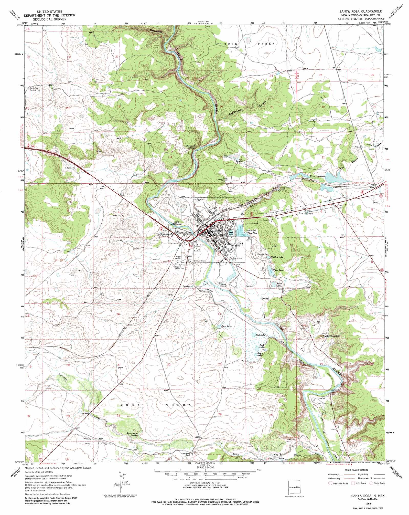
Santa Rosa Topo Map New Mexico
To zoom in, hover over the map of Santa Rosa
USGS Topo Quad 34104h6 - 1:24,000 scale
| Topo Map Name: | Santa Rosa |
| USGS Topo Quad ID: | 34104h6 |
| Print Size: | ca. 21 1/4" wide x 27" high |
| Southeast Coordinates: | 34.875° N latitude / 104.625° W longitude |
| Map Center Coordinates: | 34.9375° N latitude / 104.6875° W longitude |
| U.S. State: | NM |
| Filename: | o34104h6.jpg |
| Download Map JPG Image: | Santa Rosa topo map 1:24,000 scale |
| Map Type: | Topographic |
| Topo Series: | 7.5´ |
| Map Scale: | 1:24,000 |
| Source of Map Images: | United States Geological Survey (USGS) |
| Alternate Map Versions: |
Santa Rosa NM 1963, updated 1965 Download PDF Buy paper map Santa Rosa NM 1963, updated 1986 Download PDF Buy paper map Santa Rosa NM 2010 Download PDF Buy paper map Santa Rosa NM 2013 Download PDF Buy paper map Santa Rosa NM 2017 Download PDF Buy paper map |
1:24,000 Topo Quads surrounding Santa Rosa
Pedro Miguel Peak |
Horse Pasture Tank |
Bar Y Ranch |
Mesa Cherisco |
Mesita Del Gato |
Mesita De Guadalupe |
Colonias |
Catfish Falls |
Sacaton Draw |
Cuervo |
San Ignacio |
Pastura Ne |
Santa Rosa |
Sunshine Mesa |
Harben Lake |
Pastura |
Pastura Se |
Puerto Creek |
Puerto De Luna |
Fallon Ranch |
El Morro Ranch Nw |
Laguna De Los Terreros |
Borica |
Ojo Negro Creek |
Gibbons Ranch |
> Back to 34104e1 at 1:100,000 scale
> Back to 34104a1 at 1:250,000 scale
> Back to U.S. Topo Maps home
Santa Rosa topo map: Gazetteer
Santa Rosa: Airports
Santa Rosa Landing Field elevation 1552m 5091′Santa Rosa Municipal Airport elevation 1454m 4770′
Santa Rosa: Canals
Casaus Ditch elevation 1390m 4560′Santa Rosa: Dams
Power Dam Lake elevation 1384m 4540′Railroad Reservoir Number One Dam elevation 1421m 4662′
Railroad Reservoir Number Two Dam elevation 1429m 4688′
Santa Rosa: Lakes
Bass Lake elevation 1401m 4596′Blue Hole elevation 1402m 4599′
Hidden Lake elevation 1398m 4586′
Park Lake elevation 1400m 4593′
Perch Lake elevation 1400m 4593′
Post Lake elevation 1394m 4573′
Rock Lake elevation 1395m 4576′
Swan Lake elevation 1395m 4576′
Tres Lagunas elevation 1424m 4671′
Twin Lake elevation 1402m 4599′
Santa Rosa: Mines
Tapia Pit elevation 1406m 4612′Santa Rosa: Parks
Santa Rosa Historical Marker elevation 1407m 4616′Santa Rosa: Populated Places
Agua Negra (historical) elevation 1395m 4576′Santa Rosa elevation 1407m 4616′
Santa Rosa: Post Offices
Santa Rosa Post Office elevation 1402m 4599′Santa Rosa: Springs
Agua Negra Springs elevation 1400m 4593′Bass Lake Springs elevation 1403m 4603′
Blue Hole elevation 1402m 4599′
Cottonwood Springs elevation 1398m 4586′
Park Lake elevation 1401m 4596′
Santa Rosa: Streams
El Rito Creek elevation 1379m 4524′Los Tanos Creek elevation 1431m 4694′
Pintada Arroyo elevation 1396m 4580′
Santa Rosa: Summits
Table Mountain elevation 1437m 4714′Santa Rosa: Valleys
Cañoncitos elevation 1402m 4599′Rattlesnake Canyon elevation 1398m 4586′
Santa Rosa digital topo map on disk
Buy this Santa Rosa topo map showing relief, roads, GPS coordinates and other geographical features, as a high-resolution digital map file on DVD: