Tecolote Peak Topo Map New Mexico
To zoom in, hover over the map of Tecolote Peak
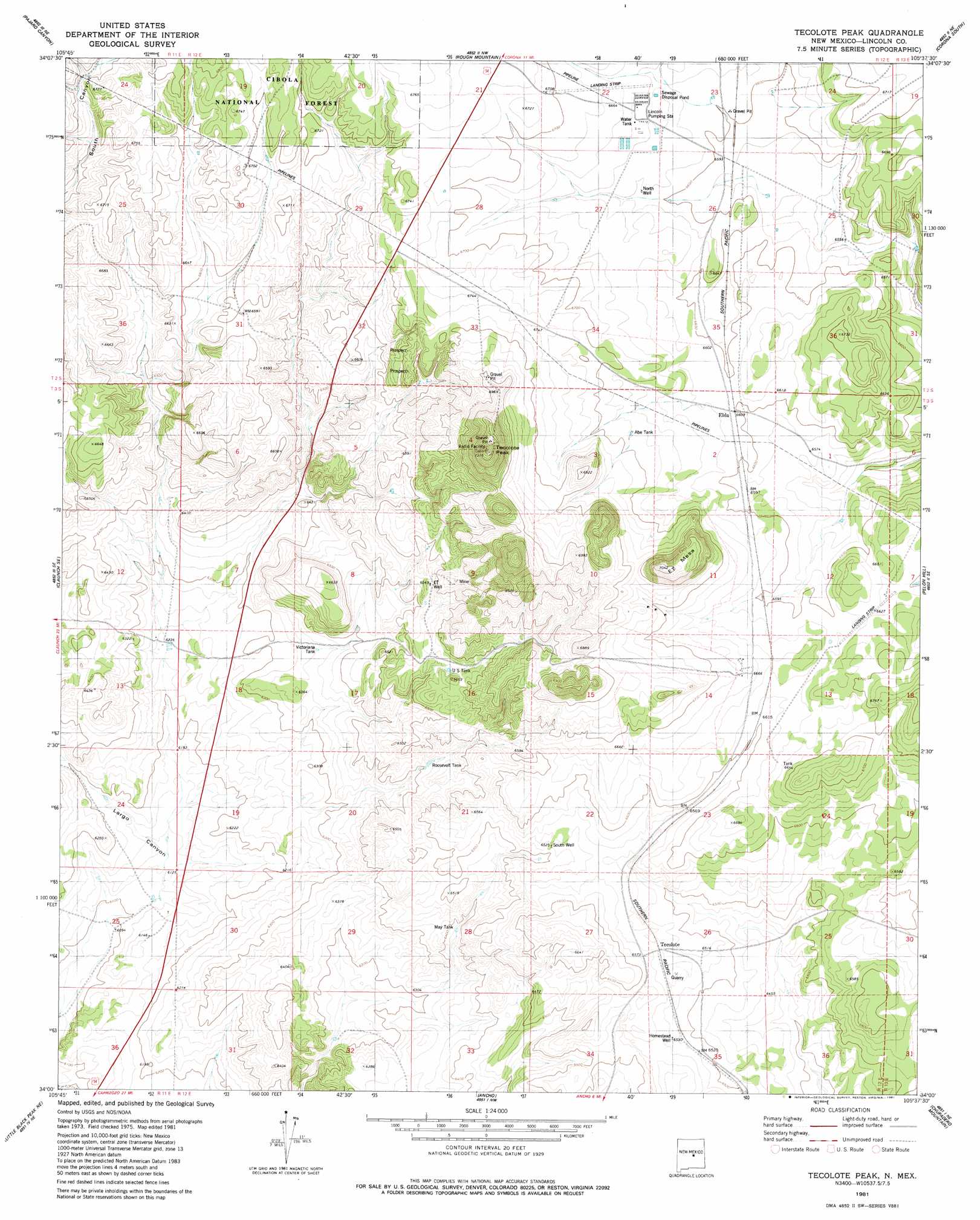
USGS Topo Quad 34105a6 - 1:24,000 scale
| Topo Map Name: | Tecolote Peak |
| USGS Topo Quad ID: | 34105a6 |
| Print Size: | ca. 21 1/4" wide x 27" high |
| Southeast Coordinates: | 34° N latitude / 105.625° W longitude |
| Map Center Coordinates: | 34.0625° N latitude / 105.6875° W longitude |
| U.S. State: | NM |
| Filename: | o34105a6.jpg |
| Download Map JPG Image: | Tecolote Peak topo map 1:24,000 scale |
| Map Type: | Topographic |
| Topo Series: | 7.5´ |
| Map Scale: | 1:24,000 |
| Source of Map Images: | United States Geological Survey (USGS) |
| Alternate Map Versions: |
Tecolote Peak NM 1981, updated 1981 Download PDF Buy paper map Tecolote Peak NM 1995, updated 1998 Download PDF Buy paper map Tecolote Peak NM 2011 Download PDF Buy paper map Tecolote Peak NM 2013 Download PDF Buy paper map Tecolote Peak NM 2017 Download PDF Buy paper map |
| FStopo: | US Forest Service topo Tecolote Peak is available: Download FStopo PDF Download FStopo TIF |
1:24,000 Topo Quads surrounding Tecolote Peak
Progresso Sw |
Progresso Se |
Cedarvale |
Corono North |
Camaleon Draw West |
Claunch |
Pajaro Canyon |
Rough Mountain |
Corona South |
Gallo Spring Canyon |
Polecat Draw |
Claunch Se |
Tecolote Peak |
Pelan Hill |
Red Bluff Draw West |
Dulce Draw |
Little Black Peak Ne |
Ancho |
Chupadero Mountain |
Hasperos Camp |
Little Black Peak |
Lone Mountain |
White Oaks North |
Jicarilla Peak |
Box Lake |
> Back to 34105a1 at 1:100,000 scale
> Back to 34104a1 at 1:250,000 scale
> Back to U.S. Topo Maps home
Tecolote Peak topo map: Gazetteer
Tecolote Peak: Airports
Lincoln Station Airport elevation 2035m 6676′Tecolote Peak: Mines
Bessemer Mine elevation 2021m 6630′Betty Prospect elevation 2032m 6666′
Bond Mine elevation 2107m 6912′
Bond Number Two Mine elevation 2107m 6912′
Consolidated Mine elevation 2008m 6587′
Consolidated Number Three elevation 2021m 6630′
Contact elevation 1967m 6453′
Elda Mine elevation 2021m 6630′
Iron Age Mine elevation 2067m 6781′
Iron City Mine elevation 2067m 6781′
Iron Contact Mine elevation 2021m 6630′
Iron Edge Mine elevation 2067m 6781′
Iron Handle Mine elevation 2067m 6781′
Iron Monument Lode elevation 2117m 6945′
Iron Pan Mine elevation 2008m 6587′
Iron Rail Mine elevation 2021m 6630′
Tecolote Peaks Iron Claim elevation 2130m 6988′
Tecolote Peak: Populated Places
Tecolote elevation 1994m 6541′Tecolote Peak: Reservoirs
Abe Tank elevation 2036m 6679′Martin Tank elevation 2033m 6669′
May Tank elevation 1945m 6381′
Roosevelt Tank elevation 1954m 6410′
US Tank elevation 1993m 6538′
Victoriana Tank elevation 1939m 6361′
Tecolote Peak: Summits
ET Mesa elevation 2141m 7024′Tecolote Peak elevation 2225m 7299′
Tecolote Peak: Wells
ET Well elevation 1999m 6558′Homestead Well elevation 1993m 6538′
North Well elevation 2019m 6624′
South Well elevation 1990m 6528′
Tecolote Peak digital topo map on disk
Buy this Tecolote Peak topo map showing relief, roads, GPS coordinates and other geographical features, as a high-resolution digital map file on DVD: