Duran Topo Map New Mexico
To zoom in, hover over the map of Duran
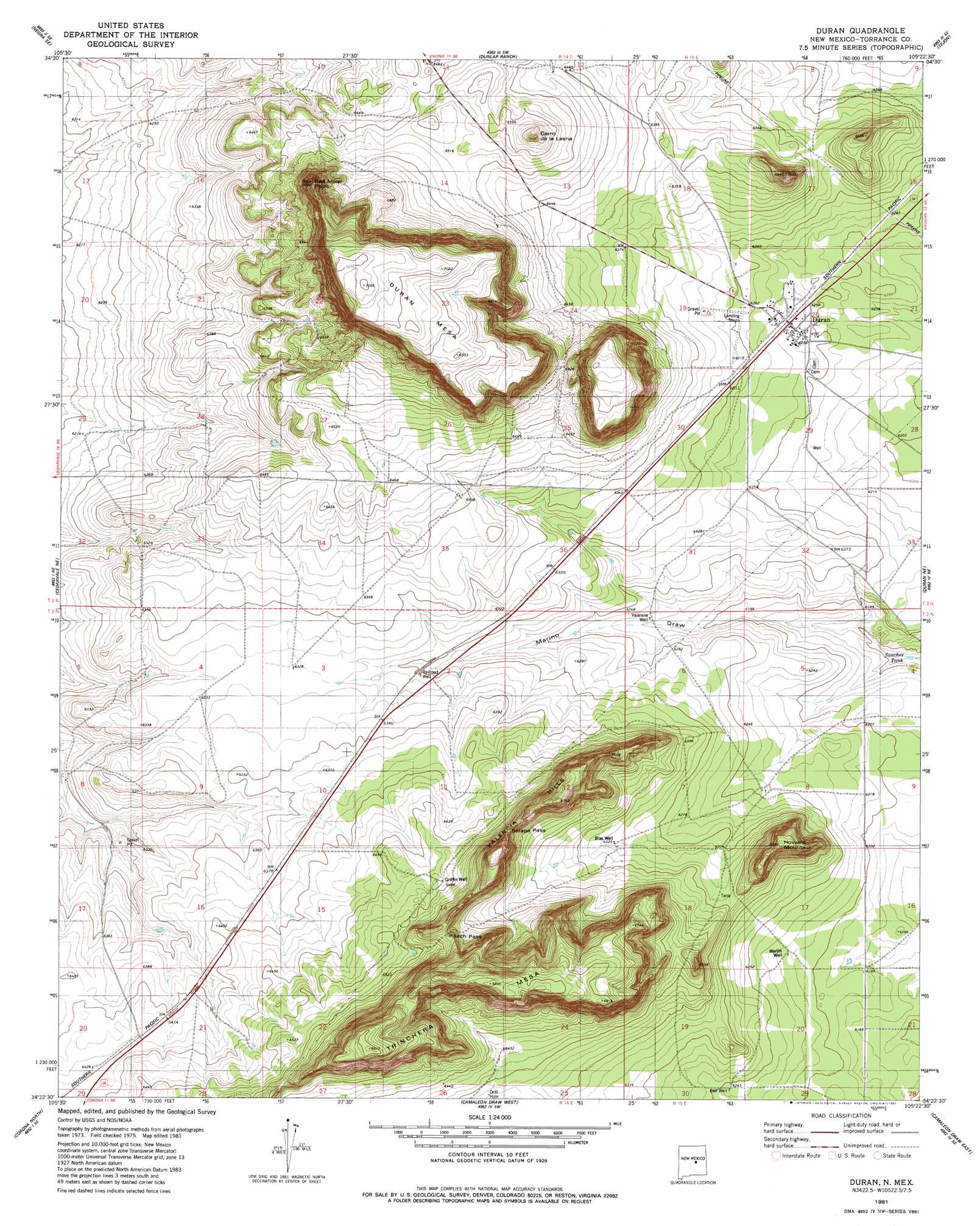
USGS Topo Quad 34105d4 - 1:24,000 scale
| Topo Map Name: | Duran |
| USGS Topo Quad ID: | 34105d4 |
| Print Size: | ca. 21 1/4" wide x 27" high |
| Southeast Coordinates: | 34.375° N latitude / 105.375° W longitude |
| Map Center Coordinates: | 34.4375° N latitude / 105.4375° W longitude |
| U.S. State: | NM |
| Filename: | o34105d4.jpg |
| Download Map JPG Image: | Duran topo map 1:24,000 scale |
| Map Type: | Topographic |
| Topo Series: | 7.5´ |
| Map Scale: | 1:24,000 |
| Source of Map Images: | United States Geological Survey (USGS) |
| Alternate Map Versions: |
Duran NM 1981, updated 1981 Download PDF Buy paper map Duran NM 2010 Download PDF Buy paper map Duran NM 2013 Download PDF Buy paper map Duran NM 2017 Download PDF Buy paper map |
1:24,000 Topo Quads surrounding Duran
Pedernal |
Negra |
Encino |
Santa Barbara Lake |
Mesa Leon |
Negra Sw |
Negra Se |
Dunlap Ranch |
Tejon |
Vaughn |
Pino Mountain |
Cedarvale Ne |
Duran |
Duran Ne |
Gacho Hill Nw |
Cedarvale |
Corono North |
Camaleon Draw West |
Camaleon Draw East |
Gacho Hill Sw |
Rough Mountain |
Corona South |
Gallo Spring Canyon |
Gallo Spring Canyon Ne |
Cowboy Mesa Nw |
> Back to 34105a1 at 1:100,000 scale
> Back to 34104a1 at 1:250,000 scale
> Back to U.S. Topo Maps home
Duran topo map: Gazetteer
Duran: Gaps
Roach Pass elevation 2014m 6607′Serape Pass elevation 2020m 6627′
Duran: Mines
Garner Mine elevation 1924m 6312′Duran: Populated Places
Duran elevation 1913m 6276′Duran: Post Offices
Duran Post Office elevation 1913m 6276′Duran: Ranges
Valencia Hills elevation 2062m 6765′Duran: Reservoirs
Sanchez Tank elevation 1870m 6135′Duran: Summits
Cerro de la Lesna elevation 2038m 6686′Duran Mesa elevation 2150m 7053′
Howard Mountain elevation 2007m 6584′
Trinchera Mesa elevation 2108m 6916′
Duran: Wells
Bell Well elevation 1904m 6246′Blas Well elevation 1929m 6328′
Griffin Well elevation 1978m 6489′
Martin Well elevation 1895m 6217′
Railroad Well elevation 1922m 6305′
Valencia Well elevation 1899m 6230′
Duran digital topo map on disk
Buy this Duran topo map showing relief, roads, GPS coordinates and other geographical features, as a high-resolution digital map file on DVD: