Pinavete Canyon Topo Map New Mexico
To zoom in, hover over the map of Pinavete Canyon
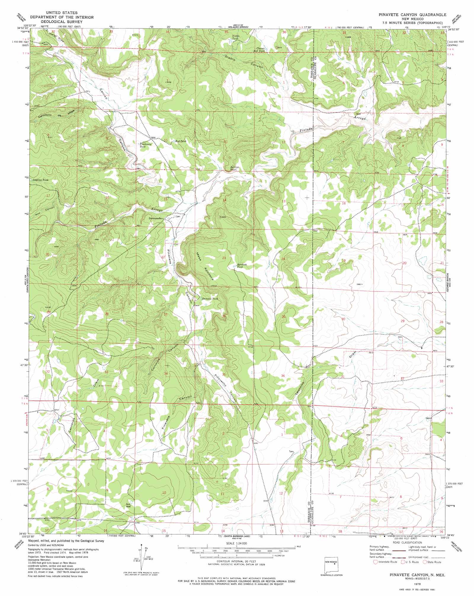
USGS Topo Quad 34105g3 - 1:24,000 scale
| Topo Map Name: | Pinavete Canyon |
| USGS Topo Quad ID: | 34105g3 |
| Print Size: | ca. 21 1/4" wide x 27" high |
| Southeast Coordinates: | 34.75° N latitude / 105.25° W longitude |
| Map Center Coordinates: | 34.8125° N latitude / 105.3125° W longitude |
| U.S. State: | NM |
| Filename: | o34105g3.jpg |
| Download Map JPG Image: | Pinavete Canyon topo map 1:24,000 scale |
| Map Type: | Topographic |
| Topo Series: | 7.5´ |
| Map Scale: | 1:24,000 |
| Source of Map Images: | United States Geological Survey (USGS) |
| Alternate Map Versions: |
Pinavete Canyon NM 1978, updated 1979 Download PDF Buy paper map Pinavete Canyon NM 2010 Download PDF Buy paper map Pinavete Canyon NM 2013 Download PDF Buy paper map Pinavete Canyon NM 2017 Download PDF Buy paper map |
1:24,000 Topo Quads surrounding Pinavete Canyon
El Cabo |
Jacinto Mesa |
Potrillo Hill |
Mesa Palo Amarillo |
Thompson Ranch |
Waller Ranch |
Palma |
Milagro Spring |
Milagro |
Pintada |
North Lucy |
Santo Nino Canyon |
Pinavete Canyon |
George Ranch |
Tapia Ranch |
Negra |
Encino |
Santa Barbara Lake |
Mesa Leon |
Burro Lake |
Negra Se |
Dunlap Ranch |
Tejon |
Vaughn |
Long Draw |
> Back to 34105e1 at 1:100,000 scale
> Back to 34104a1 at 1:250,000 scale
> Back to U.S. Topo Maps home
Pinavete Canyon topo map: Gazetteer
Pinavete Canyon: Populated Places
Derramadero elevation 1765m 5790′Pinavete Canyon: Reservoirs
Apodaca Tank elevation 1823m 5980′Chavez Red Tank elevation 1750m 5741′
Demesio Tank elevation 1780m 5839′
Diablo Tank elevation 1754m 5754′
Prudencia Tank elevation 1780m 5839′
Red Tank elevation 1775m 5823′
Pinavete Canyon: Summits
Armijo Peak elevation 1788m 5866′Mesa Apodaca elevation 1856m 6089′
Pinavete Canyon: Valleys
Cañoncito de Milpa elevation 1778m 5833′Carneros Canyon elevation 1787m 5862′
Carneros Draw elevation 1831m 6007′
Carrizo Canyon elevation 1748m 5734′
Diablo Canyon elevation 1718m 5636′
El Marge Draw elevation 1787m 5862′
Pinavetito Canyon elevation 1792m 5879′
Red Canyon elevation 1789m 5869′
Pinavete Canyon digital topo map on disk
Buy this Pinavete Canyon topo map showing relief, roads, GPS coordinates and other geographical features, as a high-resolution digital map file on DVD: