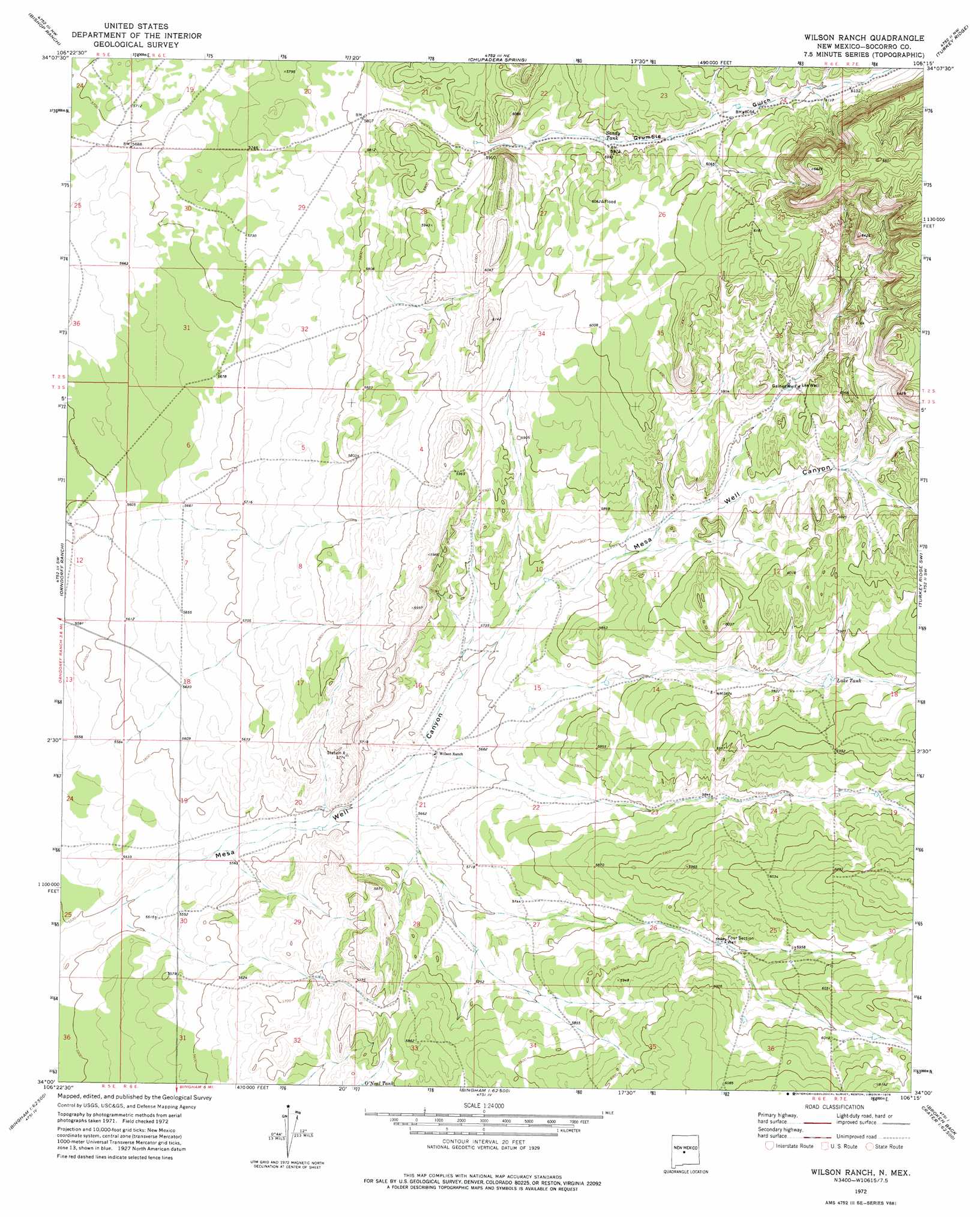
Wilson Ranch Topo Map New Mexico
To zoom in, hover over the map of Wilson Ranch
USGS Topo Quad 34106a3 - 1:24,000 scale
| Topo Map Name: | Wilson Ranch |
| USGS Topo Quad ID: | 34106a3 |
| Print Size: | ca. 21 1/4" wide x 27" high |
| Southeast Coordinates: | 34° N latitude / 106.25° W longitude |
| Map Center Coordinates: | 34.0625° N latitude / 106.3125° W longitude |
| U.S. State: | NM |
| Filename: | o34106a3.jpg |
| Download Map JPG Image: | Wilson Ranch topo map 1:24,000 scale |
| Map Type: | Topographic |
| Topo Series: | 7.5´ |
| Map Scale: | 1:24,000 |
| Source of Map Images: | United States Geological Survey (USGS) |
| Alternate Map Versions: |
Wilson Ranch NM 1972, updated 1975 Download PDF Buy paper map Wilson Ranch NM 2010 Download PDF Buy paper map Wilson Ranch NM 2013 Download PDF Buy paper map Wilson Ranch NM 2017 Download PDF Buy paper map |
1:24,000 Topo Quads surrounding Wilson Ranch
Cerro Montoso |
Rayo Hills |
Chupadera |
Bigbee Draw |
Gran Quivira |
Sierra Larga North |
Bishop Ranch |
Chupadera Spring |
Turkey Ridge |
Turkey Ridge Ne |
Sierra Larga South |
Orndorff Ranch |
Wilson Ranch |
Turkey Ridge Sw |
Cat Mesa |
Prairie Spring |
Wrye Peak Nw |
Wrye Peak |
Cooper Canyon |
Lovelace Mesa |
Cerro De La Campana Se |
Wrye Peak Sw |
Garden Spring Canyon |
Pink Peak |
Broken Back Crater |
> Back to 34106a1 at 1:100,000 scale
> Back to 34106a1 at 1:250,000 scale
> Back to U.S. Topo Maps home
Wilson Ranch topo map: Gazetteer
Wilson Ranch: Reservoirs
Lake Tank elevation 1811m 5941′O'Neal Tank elevation 1754m 5754′
Sandy Tank elevation 1818m 5964′
Wilson Ranch: Springs
Chupadera elevation 1846m 6056′Wilson Ranch: Valleys
Grumble Gulch elevation 1773m 5816′Wilson Ranch: Wells
Four Section Well elevation 1798m 5898′Gaines Well elevation 1819m 5967′
Lee Well elevation 1823m 5980′
Wilson Ranch digital topo map on disk
Buy this Wilson Ranch topo map showing relief, roads, GPS coordinates and other geographical features, as a high-resolution digital map file on DVD: