Bishop Ranch Topo Map New Mexico
To zoom in, hover over the map of Bishop Ranch
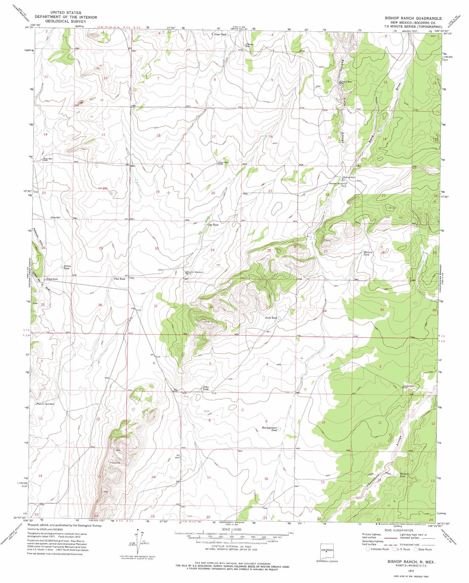
USGS Topo Quad 34106b4 - 1:24,000 scale
| Topo Map Name: | Bishop Ranch |
| USGS Topo Quad ID: | 34106b4 |
| Print Size: | ca. 21 1/4" wide x 27" high |
| Southeast Coordinates: | 34.125° N latitude / 106.375° W longitude |
| Map Center Coordinates: | 34.1875° N latitude / 106.4375° W longitude |
| U.S. State: | NM |
| Filename: | o34106b4.jpg |
| Download Map JPG Image: | Bishop Ranch topo map 1:24,000 scale |
| Map Type: | Topographic |
| Topo Series: | 7.5´ |
| Map Scale: | 1:24,000 |
| Source of Map Images: | United States Geological Survey (USGS) |
| Alternate Map Versions: |
Bishop Ranch NM 1972, updated 1975 Download PDF Buy paper map Bishop Ranch NM 2010 Download PDF Buy paper map Bishop Ranch NM 2013 Download PDF Buy paper map Bishop Ranch NM 2017 Download PDF Buy paper map |
1:24,000 Topo Quads surrounding Bishop Ranch
Black Butte |
Becker |
Scholle |
Abo |
Mesa Draw |
Becker Sw |
Cerro Montoso |
Rayo Hills |
Chupadera |
Bigbee Draw |
Sierra De La Cruz |
Sierra Larga North |
Bishop Ranch |
Chupadera Spring |
Turkey Ridge |
Bustos Well |
Sierra Larga South |
Orndorff Ranch |
Wilson Ranch |
Turkey Ridge Sw |
Canon Agua Buena |
Prairie Spring |
Wrye Peak Nw |
Wrye Peak |
Cooper Canyon |
> Back to 34106a1 at 1:100,000 scale
> Back to 34106a1 at 1:250,000 scale
> Back to U.S. Topo Maps home
Bishop Ranch topo map: Gazetteer
Bishop Ranch: Reservoirs
Arrese Tank elevation 1743m 5718′Baumgardner Tank elevation 1730m 5675′
Flat Tank elevation 1755m 5757′
Gyp Tank elevation 1786m 5859′
Jesus Tank elevation 1741m 5711′
Lupe Tank elevation 1883m 6177′
Manuel Tank elevation 1802m 5912′
Roebuck Tank elevation 1718m 5636′
Twin Tank elevation 1776m 5826′
Bishop Ranch: Streams
Rancho Viejo Arroyo elevation 1700m 5577′Bishop Ranch: Valleys
Cañon de la Rosa elevation 1736m 5695′Patterson Draw elevation 1742m 5715′
Sand Draw elevation 1823m 5980′
Bishop Ranch: Wells
Canyon Well elevation 1865m 6118′Indian Well elevation 1751m 5744′
Manuel Water Well elevation 1824m 5984′
Manuel Well elevation 1825m 5987′
Marr Well elevation 1779m 5836′
New Well elevation 1758m 5767′
Romero Well elevation 1893m 6210′
Round Tank Well elevation 1726m 5662′
Shaw Well elevation 1815m 5954′
Bishop Ranch digital topo map on disk
Buy this Bishop Ranch topo map showing relief, roads, GPS coordinates and other geographical features, as a high-resolution digital map file on DVD: