Cerro Montoso Topo Map New Mexico
To zoom in, hover over the map of Cerro Montoso
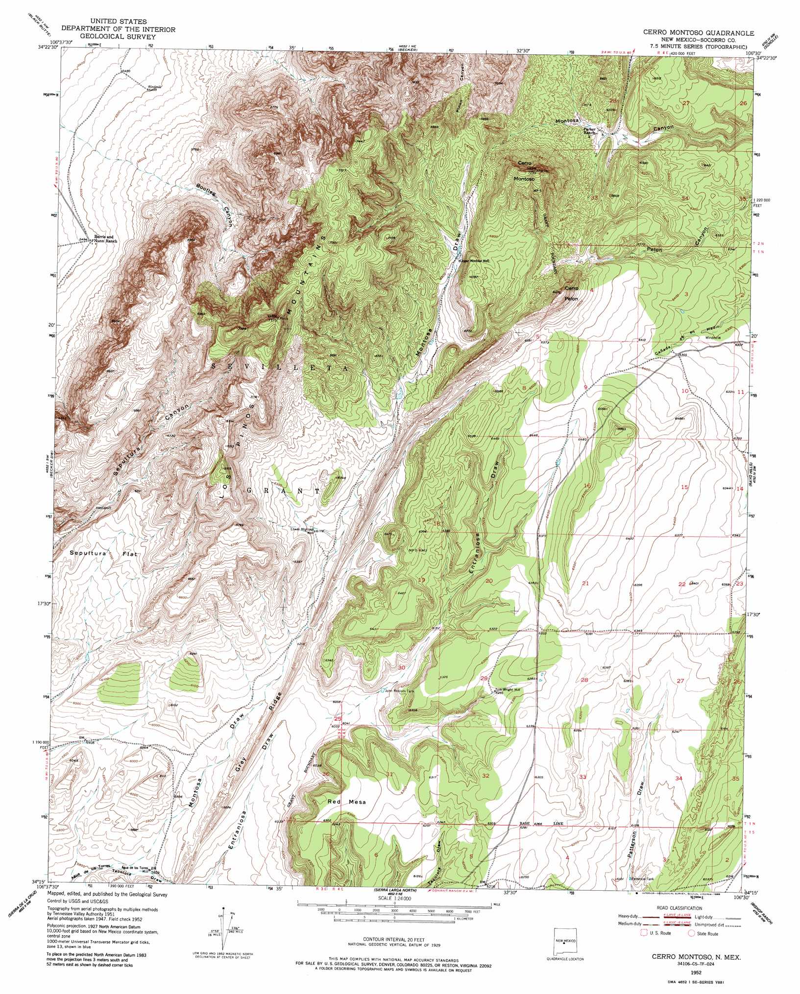
USGS Topo Quad 34106c5 - 1:24,000 scale
| Topo Map Name: | Cerro Montoso |
| USGS Topo Quad ID: | 34106c5 |
| Print Size: | ca. 21 1/4" wide x 27" high |
| Southeast Coordinates: | 34.25° N latitude / 106.5° W longitude |
| Map Center Coordinates: | 34.3125° N latitude / 106.5625° W longitude |
| U.S. State: | NM |
| Filename: | o34106c5.jpg |
| Download Map JPG Image: | Cerro Montoso topo map 1:24,000 scale |
| Map Type: | Topographic |
| Topo Series: | 7.5´ |
| Map Scale: | 1:24,000 |
| Source of Map Images: | United States Geological Survey (USGS) |
| Alternate Map Versions: |
Cerro Montoso NM 1952, updated 1959 Download PDF Buy paper map Cerro Montoso NM 1952, updated 1975 Download PDF Buy paper map Cerro Montoso NM 1952, updated 1986 Download PDF Buy paper map Cerro Montoso NM 2010 Download PDF Buy paper map Cerro Montoso NM 2013 Download PDF Buy paper map Cerro Montoso NM 2017 Download PDF Buy paper map |
1:24,000 Topo Quads surrounding Cerro Montoso
Veguita |
Turn |
Tome Se |
Manzano Peak |
Punta De Agua |
Abeytas |
Black Butte |
Becker |
Scholle |
Abo |
La Joya |
Becker Sw |
Cerro Montoso |
Rayo Hills |
Chupadera |
Mesa Del Yeso |
Sierra De La Cruz |
Sierra Larga North |
Bishop Ranch |
Chupadera Spring |
Loma De Las Canas |
Bustos Well |
Sierra Larga South |
Orndorff Ranch |
Wilson Ranch |
> Back to 34106a1 at 1:100,000 scale
> Back to 34106a1 at 1:250,000 scale
> Back to U.S. Topo Maps home
Cerro Montoso topo map: Gazetteer
Cerro Montoso: Flats
Sepultura Flat elevation 1860m 6102′Cerro Montoso: Mines
Conqueror Mine elevation 1801m 5908′Cerro Montoso: Reservoirs
John Renlods Tank elevation 1857m 6092′Patterson Tank elevation 1852m 6076′
Cerro Montoso: Ridges
Grey Montosa Ridge elevation 1826m 5990′Grey Ridge elevation 1850m 6069′
Los Pinos Mountains elevation 2248m 7375′
Cerro Montoso: Summits
Cerro Montoso elevation 2191m 7188′Cerro Pelon elevation 2112m 6929′
Red Mesa elevation 1941m 6368′
Cerro Montoso: Valleys
Montosa Draw elevation 1774m 5820′Tecolote Draw elevation 1785m 5856′
Cerro Montoso: Wells
Aqua Tores Water Well elevation 1780m 5839′Burris HQ Water Well elevation 1676m 5498′
Lower Montosa Well elevation 1882m 6174′
Parker Water Well elevation 1955m 6414′
Test Water Well 2 elevation 1821m 5974′
Upper Montosa Well elevation 1989m 6525′
Cerro Montoso digital topo map on disk
Buy this Cerro Montoso topo map showing relief, roads, GPS coordinates and other geographical features, as a high-resolution digital map file on DVD: