Becker Topo Map New Mexico
To zoom in, hover over the map of Becker
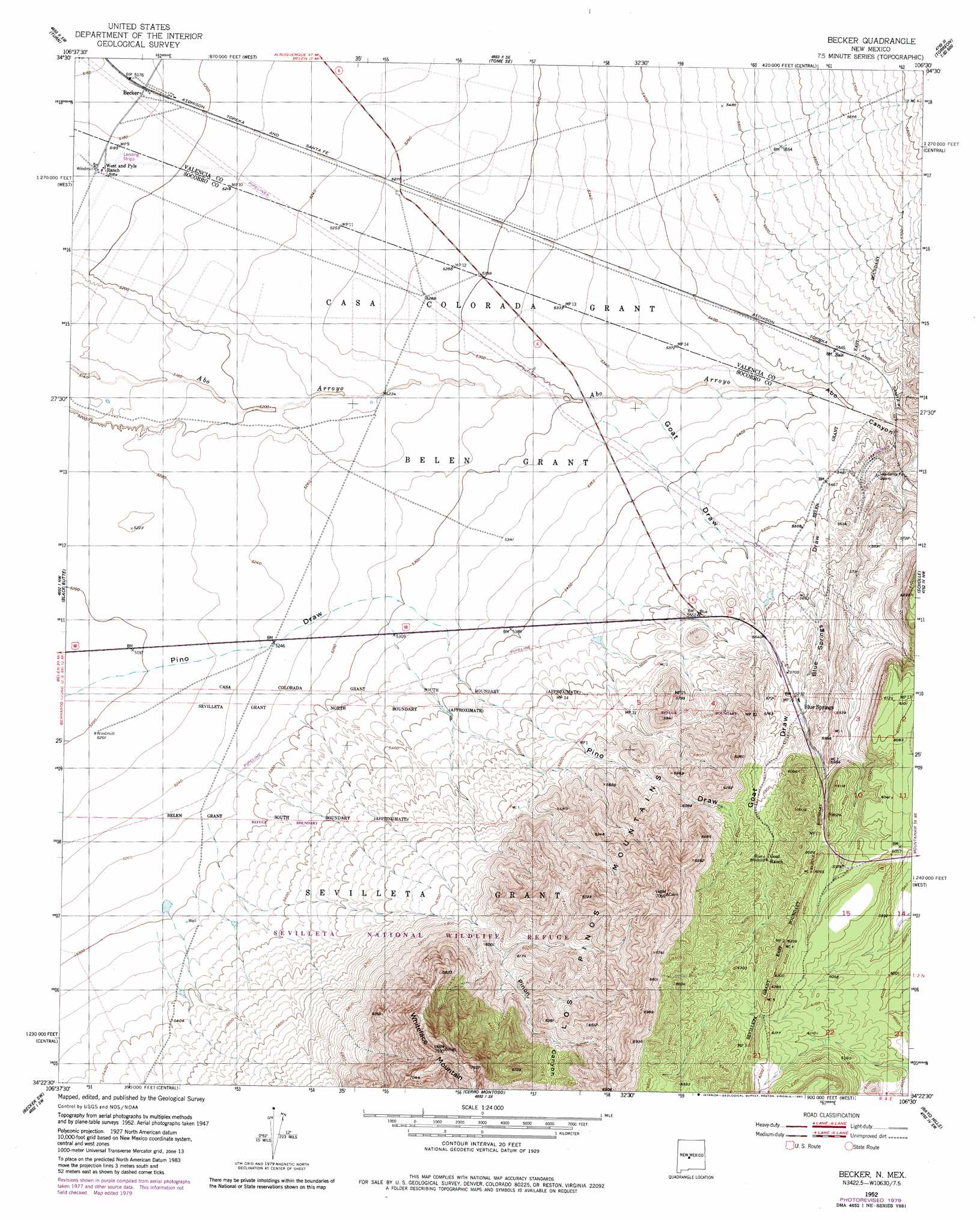
USGS Topo Quad 34106d5 - 1:24,000 scale
| Topo Map Name: | Becker |
| USGS Topo Quad ID: | 34106d5 |
| Print Size: | ca. 21 1/4" wide x 27" high |
| Southeast Coordinates: | 34.375° N latitude / 106.5° W longitude |
| Map Center Coordinates: | 34.4375° N latitude / 106.5625° W longitude |
| U.S. State: | NM |
| Filename: | o34106d5.jpg |
| Download Map JPG Image: | Becker topo map 1:24,000 scale |
| Map Type: | Topographic |
| Topo Series: | 7.5´ |
| Map Scale: | 1:24,000 |
| Source of Map Images: | United States Geological Survey (USGS) |
| Alternate Map Versions: |
Becker NM 1952, updated 1953 Download PDF Buy paper map Becker NM 1952, updated 1980 Download PDF Buy paper map Becker NM 2010 Download PDF Buy paper map Becker NM 2013 Download PDF Buy paper map Becker NM 2017 Download PDF Buy paper map |
1:24,000 Topo Quads surrounding Becker
Belen |
Tome |
Tome Ne |
Capilla Peak |
Torreon |
Veguita |
Turn |
Tome Se |
Manzano Peak |
Punta De Agua |
Abeytas |
Black Butte |
Becker |
Scholle |
Abo |
La Joya |
Becker Sw |
Cerro Montoso |
Rayo Hills |
Chupadera |
Mesa Del Yeso |
Sierra De La Cruz |
Sierra Larga North |
Bishop Ranch |
Chupadera Spring |
> Back to 34106a1 at 1:100,000 scale
> Back to 34106a1 at 1:250,000 scale
> Back to U.S. Topo Maps home
Becker topo map: Gazetteer
Becker: Airports
Burris Ranch Number 1 Airport elevation 1586m 5203′Becker: Mines
Blue Springs Quarry elevation 1767m 5797′Becker: Populated Places
Becker elevation 1578m 5177′Becker: Springs
Blue Spring elevation 1751m 5744′Becker: Summits
Whiteface Mountain elevation 2294m 7526′Becker: Valleys
Abo Canyon elevation 1649m 5410′Blue Springs Draw elevation 1633m 5357′
Goat Draw elevation 1623m 5324′
Pinon Canyon elevation 1608m 5275′
Becker: Wells
10019 Water Well elevation 1578m 5177′Pino Water Well elevation 1885m 6184′
Becker digital topo map on disk
Buy this Becker topo map showing relief, roads, GPS coordinates and other geographical features, as a high-resolution digital map file on DVD: