Willard Topo Map New Mexico
To zoom in, hover over the map of Willard
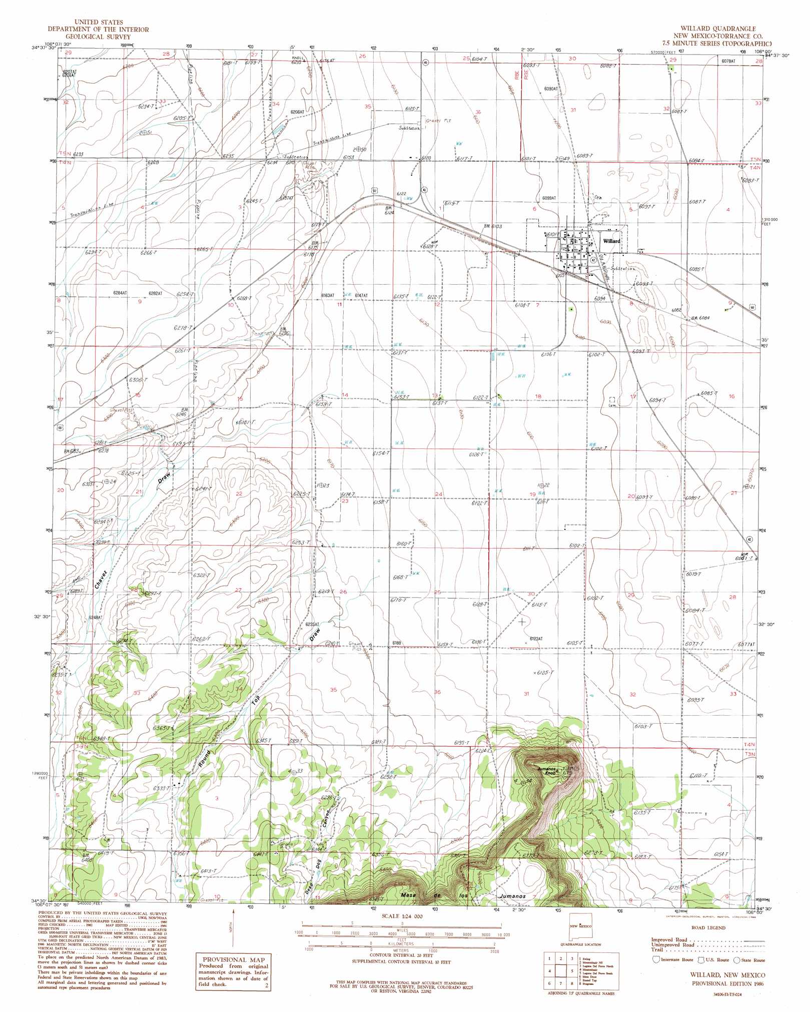
USGS Topo Quad 34106e1 - 1:24,000 scale
| Topo Map Name: | Willard |
| USGS Topo Quad ID: | 34106e1 |
| Print Size: | ca. 21 1/4" wide x 27" high |
| Southeast Coordinates: | 34.5° N latitude / 106° W longitude |
| Map Center Coordinates: | 34.5625° N latitude / 106.0625° W longitude |
| U.S. State: | NM |
| Filename: | o34106e1.jpg |
| Download Map JPG Image: | Willard topo map 1:24,000 scale |
| Map Type: | Topographic |
| Topo Series: | 7.5´ |
| Map Scale: | 1:24,000 |
| Source of Map Images: | United States Geological Survey (USGS) |
| Alternate Map Versions: |
Willard NM 1986, updated 1986 Download PDF Buy paper map Willard NM 2010 Download PDF Buy paper map Willard NM 2013 Download PDF Buy paper map Willard NM 2017 Download PDF Buy paper map |
1:24,000 Topo Quads surrounding Willard
Tajique |
Milbourn Ranch |
Estancia |
Lobo Hill Sw |
Lobo Hill Se |
Torreon |
Ewing |
Mountainair Ne |
Laguna Del Perro North |
Lucy |
Punta De Agua |
Mountainair |
Willard |
Laguna Del Perro South |
Rattlesnake Hill |
Abo |
Mesa Draw |
Round Top |
Progresso |
Progresso Ne |
Chupadera |
Bigbee Draw |
Gran Quivira |
Progresso Sw |
Progresso Se |
> Back to 34106e1 at 1:100,000 scale
> Back to 34106a1 at 1:250,000 scale
> Back to U.S. Topo Maps home
Willard topo map: Gazetteer
Willard: Airports
J and M Farms Airport elevation 1878m 6161′Willard: Mines
Bronco Pit elevation 1918m 6292′Willard: Populated Places
Willard elevation 1859m 6099′Willard: Post Offices
Willard Post Office elevation 1859m 6099′Willard: Summits
Jumanes Knob elevation 2055m 6742′Willard: Valleys
Chavez Draw elevation 1912m 6272′Dead Dog Canyon elevation 1898m 6227′
Round Top Draw elevation 1882m 6174′
Tabet Draw elevation 1895m 6217′
Willard: Wells
10004 Water Well elevation 1872m 6141′10005 Water Well elevation 1876m 6154′
10019 Water Well elevation 1865m 6118′
Willard digital topo map on disk
Buy this Willard topo map showing relief, roads, GPS coordinates and other geographical features, as a high-resolution digital map file on DVD: