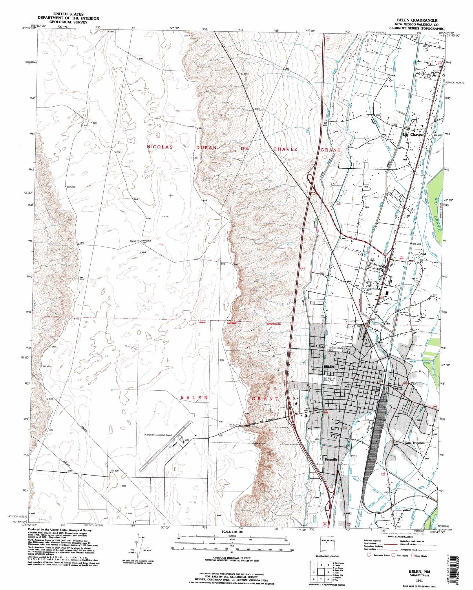
Belen Topo Map New Mexico
To zoom in, hover over the map of Belen
USGS Topo Quad 34106f7 - 1:24,000 scale
| Topo Map Name: | Belen |
| USGS Topo Quad ID: | 34106f7 |
| Print Size: | ca. 21 1/4" wide x 27" high |
| Southeast Coordinates: | 34.625° N latitude / 106.75° W longitude |
| Map Center Coordinates: | 34.6875° N latitude / 106.8125° W longitude |
| U.S. State: | NM |
| Filename: | o34106f7.jpg |
| Download Map JPG Image: | Belen topo map 1:24,000 scale |
| Map Type: | Topographic |
| Topo Series: | 7.5´ |
| Map Scale: | 1:24,000 |
| Source of Map Images: | United States Geological Survey (USGS) |
| Alternate Map Versions: |
Belen NM 1952, updated 1953 Download PDF Buy paper map Belen NM 1952, updated 1973 Download PDF Buy paper map Belen NM 1952, updated 1980 Download PDF Buy paper map Belen NM 1991, updated 1996 Download PDF Buy paper map Belen NM 2010 Download PDF Buy paper map Belen NM 2013 Download PDF Buy paper map Belen NM 2017 Download PDF Buy paper map |
1:24,000 Topo Quads surrounding Belen
South Garcia |
Dalies Nw |
Wind Mesa |
Isleta |
Hubbell Spring |
South Garcia Se |
Rio Puerco |
Dalies |
Los Lunas |
Los Lunas Se |
Mesas Mojinas |
Belen Nw |
Belen |
Tome |
Tome Ne |
Comanche Ranch |
Belen Sw |
Veguita |
Turn |
Tome Se |
Ladron Peak |
La Joya Nw |
Abeytas |
Black Butte |
Becker |
> Back to 34106e1 at 1:100,000 scale
> Back to 34106a1 at 1:250,000 scale
> Back to U.S. Topo Maps home
Belen topo map: Gazetteer
Belen: Airports
Alexander Municipal Airport elevation 1577m 5173′Belen: Canals
Belen Highline Canal elevation 1484m 4868′Belen Waste Ditch elevation 1462m 4796′
Gabaldon Drain elevation 1472m 4829′
Gabaldon Lateral elevation 1472m 4829′
Garcia Lateral Number 1 elevation 1468m 4816′
Harlan Lateral elevation 1472m 4829′
Henderson Lateral elevation 1467m 4812′
Los Chavez Drain elevation 1470m 4822′
Old Belen Ditch elevation 1467m 4812′
Sanchez Drain elevation 1463m 4799′
Sausal Drain elevation 1467m 4812′
Belen: Crossings
Belen North Interchange elevation 1468m 4816′Belen: Dams
Houston Arroyo Dam elevation 1488m 4881′Belen: Populated Places
Azul elevation 1468m 4816′Bacaville elevation 1466m 4809′
Belen elevation 1466m 4809′
Los Chavez elevation 1470m 4822′
Los Trujillos elevation 1464m 4803′
Belen: Post Offices
Bacaville Post Office (historical) elevation 1466m 4809′Belen Post Office elevation 1466m 4809′
Los Chaves Post Office (historical) elevation 1470m 4822′
Belen: Wells
10013 Water Well elevation 1471m 4826′10015 Water Well elevation 1480m 4855′
J Maes Water Well elevation 1595m 5232′
Belen digital topo map on disk
Buy this Belen topo map showing relief, roads, GPS coordinates and other geographical features, as a high-resolution digital map file on DVD: