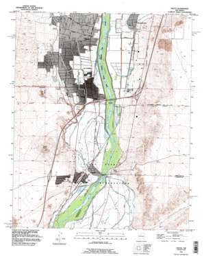
Isleta Topo Map New Mexico
To zoom in, hover over the map of Isleta
USGS Topo Quad 34106h6 - 1:24,000 scale
| Topo Map Name: | Isleta |
| USGS Topo Quad ID: | 34106h6 |
| Print Size: | ca. 21 1/4" wide x 27" high |
| Southeast Coordinates: | 34.875° N latitude / 106.625° W longitude |
| Map Center Coordinates: | 34.9375° N latitude / 106.6875° W longitude |
| U.S. State: | NM |
| Filename: | o34106h6.jpg |
| Download Map JPG Image: | Isleta topo map 1:24,000 scale |
| Map Type: | Topographic |
| Topo Series: | 7.5´ |
| Map Scale: | 1:24,000 |
| Source of Map Images: | United States Geological Survey (USGS) |
| Alternate Map Versions: |
Isleta NM 1952, updated 1954 Download PDF Buy paper map Isleta NM 1952, updated 1969 Download PDF Buy paper map Isleta NM 1952, updated 1978 Download PDF Buy paper map Isleta NM 1991, updated 1996 Download PDF Buy paper map Isleta NM 2010 Download PDF Buy paper map Isleta NM 2013 Download PDF Buy paper map Isleta NM 2017 Download PDF Buy paper map |
1:24,000 Topo Quads surrounding Isleta
> Back to 34106e1 at 1:100,000 scale
> Back to 34106a1 at 1:250,000 scale
> Back to U.S. Topo Maps home
Isleta topo map: Gazetteer
Isleta: Canals
Barr Interior Drain elevation 1498m 4914′Butte Lateral elevation 1495m 4904′
Indian Lateral elevation 1492m 4895′
Isleta Drain elevation 1500m 4921′
Isleta Indian Drain elevation 1492m 4895′
Isleta Indian Lateral elevation 1495m 4904′
Isleta Lateral elevation 1492m 4895′
Los Padillas Acequia elevation 1497m 4911′
Los Padillas Drain elevation 1499m 4917′
Putman Drain elevation 1499m 4917′
Sandhills Lateral elevation 1488m 4881′
Upper Chical Acequia elevation 1488m 4881′
Upper Chical Lateral elevation 1489m 4885′
Upper Cosique Acequia elevation 1489m 4885′
Isleta: Dams
Isleta Diversion Dam elevation 1489m 4885′Isleta: Lakes
Isleta Lakes elevation 1494m 4901′Isleta: Mines
Mc Elroy Pit elevation 1549m 5082′State Pit elevation 1603m 5259′
Isleta: Parks
Los Padillas Historical Marker elevation 1497m 4911′Pueblo of Isleta Historical Marker elevation 1491m 4891′
Isleta: Populated Places
Barr elevation 1500m 4921′Isleta elevation 1495m 4904′
Isleta Pueblo elevation 1491m 4891′
Los Padillas elevation 1497m 4911′
Mountainview elevation 1509m 4950′
Pajarito elevation 1498m 4914′
Isleta: Post Offices
Isleta Post Office elevation 1495m 4904′Padillas Post Office (historical) elevation 1497m 4911′
Pajarito Post Office (historical) elevation 1498m 4914′
Isleta: Streams
Isleta Riverside Drain elevation 1491m 4891′Isleta: Summits
Black Mesa elevation 1531m 5022′Mesa de los Padillas elevation 1547m 5075′
Parea Mesa elevation 1642m 5387′
Isleta: Wells
10001 Water Well elevation 1537m 5042′10002 Water Well elevation 1491m 4891′
10010 Water Well elevation 1500m 4921′
10011 Water Well elevation 1508m 4947′
10012 Water Well elevation 1496m 4908′
10013 Water Well elevation 1495m 4904′
10062 Water Well elevation 1543m 5062′
10063 Water Well elevation 1488m 4881′
Chava Water Well elevation 1518m 4980′
Egg Farm Test Water Well elevation 1506m 4940′
SBLF-2 Water Well elevation 1620m 5314′
Test Hole 1 water Well elevation 1495m 4904′
Test Hole 2 Water Well elevation 1494m 4901′
Test Hole 3 Water Well elevation 1494m 4901′
Test Hole 4-77 Water Well elevation 1493m 4898′
Test Hole 5-77 Water Well elevation 1492m 4895′
Test Hole 6-77 Water Well elevation 1492m 4895′
Test Hole 7-77 Water Well elevation 1492m 4895′
Test Hole 8-77 Water Well elevation 1492m 4895′
United States Bureau of Reclamation 2 Water Well elevation 1498m 4914′
Isleta digital topo map on disk
Buy this Isleta topo map showing relief, roads, GPS coordinates and other geographical features, as a high-resolution digital map file on DVD:


