Anderson Peak Topo Map New Mexico
To zoom in, hover over the map of Anderson Peak
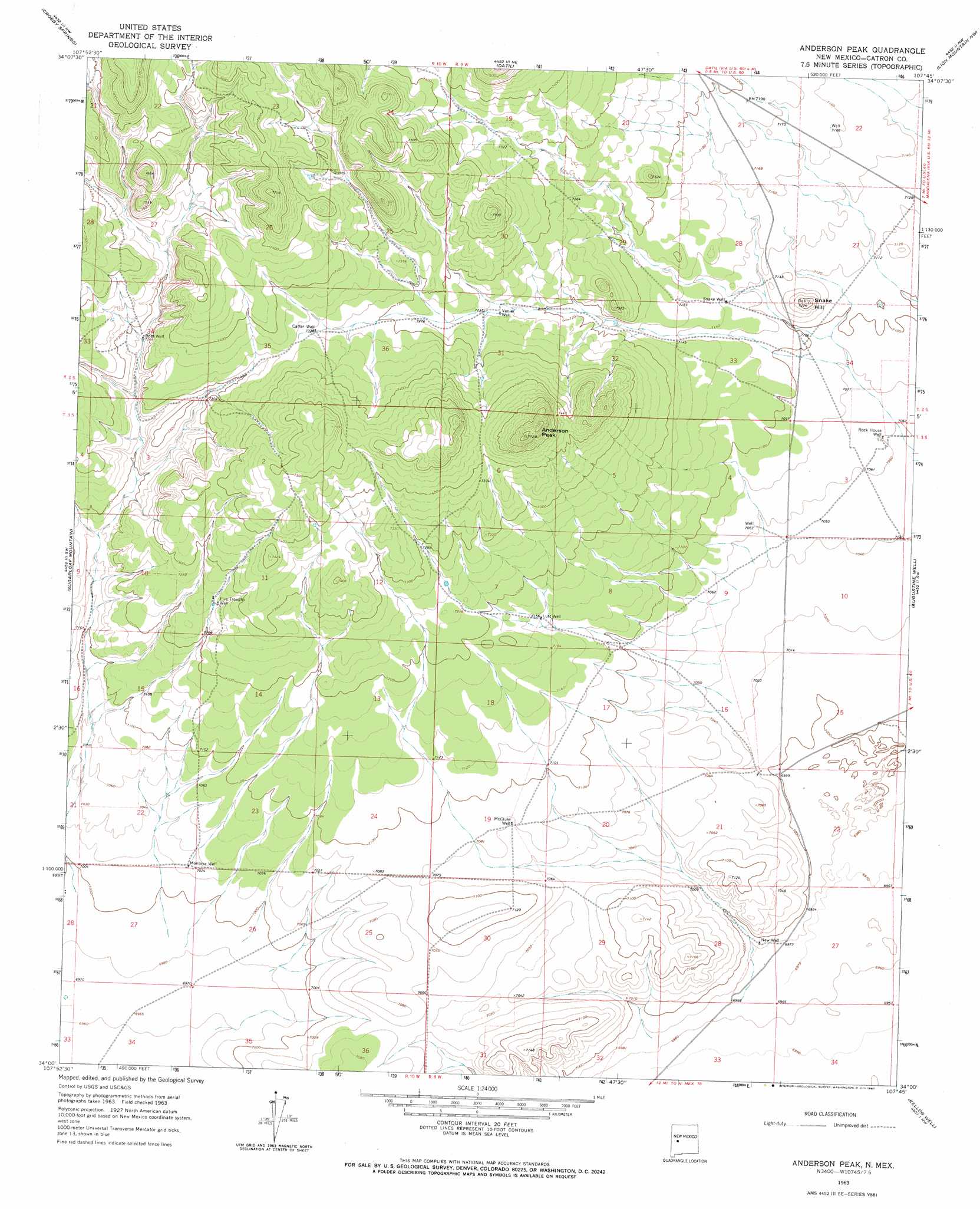
USGS Topo Quad 34107a7 - 1:24,000 scale
| Topo Map Name: | Anderson Peak |
| USGS Topo Quad ID: | 34107a7 |
| Print Size: | ca. 21 1/4" wide x 27" high |
| Southeast Coordinates: | 34° N latitude / 107.75° W longitude |
| Map Center Coordinates: | 34.0625° N latitude / 107.8125° W longitude |
| U.S. State: | NM |
| Filename: | o34107a7.jpg |
| Download Map JPG Image: | Anderson Peak topo map 1:24,000 scale |
| Map Type: | Topographic |
| Topo Series: | 7.5´ |
| Map Scale: | 1:24,000 |
| Source of Map Images: | United States Geological Survey (USGS) |
| Alternate Map Versions: |
Anderson Peak NM 1963, updated 1967 Download PDF Buy paper map Anderson Peak NM 2010 Download PDF Buy paper map Anderson Peak NM 2013 Download PDF Buy paper map Anderson Peak NM 2017 Download PDF Buy paper map |
1:24,000 Topo Quads surrounding Anderson Peak
Red Flats |
Madre Mountain |
Cal Ship Mesa |
Dog Springs |
Indian Mesa |
Cox Peak |
Crosby Springs |
Datil |
Lion Mountain Nw |
Lion Mountain |
Log Canyon |
Sugarloaf Mountain |
Anderson Peak |
Augustine Well |
Arrowhead Well |
Horse Mountain East |
Luera Mountains Nw |
C-N Lake |
Kellog Well |
Monica Saddle |
Shaw Mountain |
Luera Mountains West |
Luera Mountains East |
Oak Peak |
Bay Buck Peaks |
> Back to 34107a1 at 1:100,000 scale
> Back to 34106a1 at 1:250,000 scale
> Back to U.S. Topo Maps home
Anderson Peak topo map: Gazetteer
Anderson Peak: Summits
Anderson Peak elevation 2342m 7683′Snake Hill elevation 2198m 7211′
Anderson Peak: Wells
5 Troughs Water Well elevation 2209m 7247′Bobs Water Well elevation 2215m 7267′
Bobs Well elevation 2213m 7260′
Carter Water Well elevation 2237m 7339′
Carter Well elevation 2235m 7332′
Five Troughs Well elevation 2210m 7250′
Lutz Well elevation 2179m 7148′
M C Water Well elevation 2159m 7083′
Mcclure Well elevation 2159m 7083′
Mclure Water Well elevation 2159m 7083′
Montoya Water Well elevation 2143m 7030′
Montoya Well elevation 2143m 7030′
New Water Well elevation 2131m 6991′
New Well elevation 2130m 6988′
Rock House Water Well elevation 2153m 7063′
Rock House Well elevation 2153m 7063′
Snake Water Well elevation 2176m 7139′
Snake Well elevation 2173m 7129′
Vanier Water Well elevation 2203m 7227′
Vanier Well elevation 2203m 7227′
Anderson Peak digital topo map on disk
Buy this Anderson Peak topo map showing relief, roads, GPS coordinates and other geographical features, as a high-resolution digital map file on DVD: