Gallinas Peak Topo Map New Mexico
To zoom in, hover over the map of Gallinas Peak
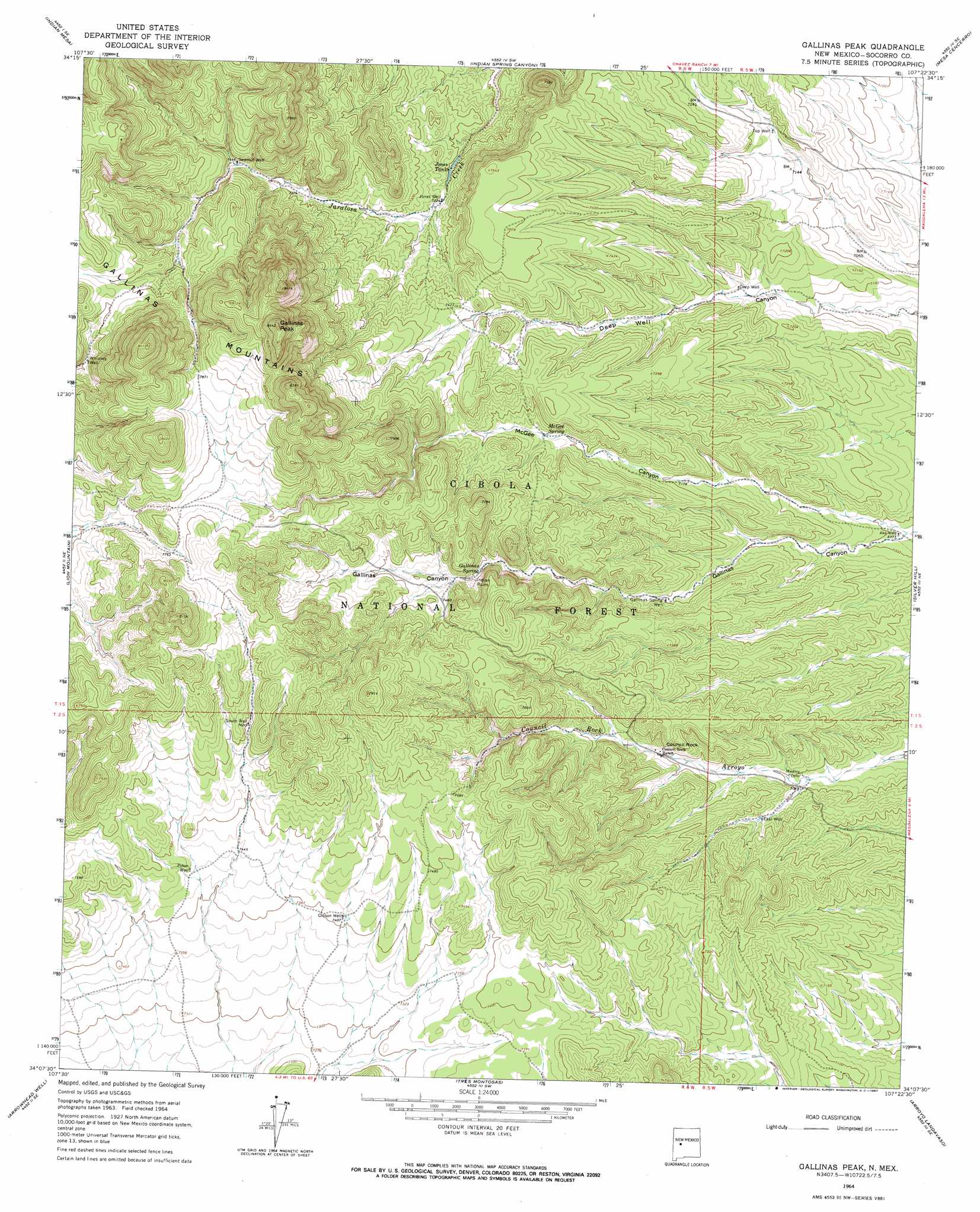
USGS Topo Quad 34107b4 - 1:24,000 scale
| Topo Map Name: | Gallinas Peak |
| USGS Topo Quad ID: | 34107b4 |
| Print Size: | ca. 21 1/4" wide x 27" high |
| Southeast Coordinates: | 34.125° N latitude / 107.375° W longitude |
| Map Center Coordinates: | 34.1875° N latitude / 107.4375° W longitude |
| U.S. State: | NM |
| Filename: | o34107b4.jpg |
| Download Map JPG Image: | Gallinas Peak topo map 1:24,000 scale |
| Map Type: | Topographic |
| Topo Series: | 7.5´ |
| Map Scale: | 1:24,000 |
| Source of Map Images: | United States Geological Survey (USGS) |
| Alternate Map Versions: |
Gallinas Peak NM 1964, updated 1967 Download PDF Buy paper map Gallinas Peak NM 1995, updated 1998 Download PDF Buy paper map Gallinas Peak NM 2011 Download PDF Buy paper map Gallinas Peak NM 2013 Download PDF Buy paper map Gallinas Peak NM 2017 Download PDF Buy paper map |
| FStopo: | US Forest Service topo Gallinas Peak is available: Download FStopo PDF Download FStopo TIF |
1:24,000 Topo Quads surrounding Gallinas Peak
D Cross Mountain |
Table Mountain |
Puertecito |
La Jara Peak |
Riley |
Dog Springs |
Indian Mesa |
Indian Spring Canyon |
Mesa Cencerro |
Carbon Springs |
Lion Mountain Nw |
Lion Mountain |
Gallinas Peak |
Silver Hill |
Granite Mountain |
Augustine Well |
Arrowhead Well |
Tres Montosas |
Arroyo Landavaso |
Magdalena |
Kellog Well |
Monica Saddle |
Mount Withington |
Squaw Peak |
South Baldy |
> Back to 34107a1 at 1:100,000 scale
> Back to 34106a1 at 1:250,000 scale
> Back to U.S. Topo Maps home
Gallinas Peak topo map: Gazetteer
Gallinas Peak: Areas
Council Rock elevation 2235m 7332′Gallinas Peak: Mines
Anabel elevation 2183m 7162′Bojo Montoso elevation 2287m 7503′
Bojo Placer Number One elevation 2169m 7116′
Gallinas Peak: Post Offices
Council Rock Post Office (historical) elevation 2206m 7237′Gallinas Peak: Ranges
Gallinas Mountains elevation 2562m 8405′Gallinas Peak: Reservoirs
Gallinas Trick Tank elevation 2400m 7874′Heifer Well elevation 2182m 7158′
Jones Tanks elevation 2190m 7185′
Rock Header Tank elevation 2277m 7470′
Gallinas Peak: Springs
Gallinas Spring elevation 2251m 7385′McGee Spring elevation 2234m 7329′
Gallinas Peak: Summits
Gallinas Peak elevation 2574m 8444′Gallinas Peak: Valleys
McGee Canyon elevation 2125m 6971′Gallinas Peak: Wells
Ake Well elevation 2127m 6978′Deep Well elevation 2184m 7165′
East Well elevation 2180m 7152′
Gallinas Spring Dug Well elevation 2194m 7198′
Gibson Well elevation 2259m 7411′
Jones Well elevation 2201m 7221′
Piñon Well elevation 2271m 7450′
Sawmill Well elevation 2271m 7450′
South Well elevation 2316m 7598′
Whiskey Well elevation 2318m 7604′
Gallinas Peak digital topo map on disk
Buy this Gallinas Peak topo map showing relief, roads, GPS coordinates and other geographical features, as a high-resolution digital map file on DVD: