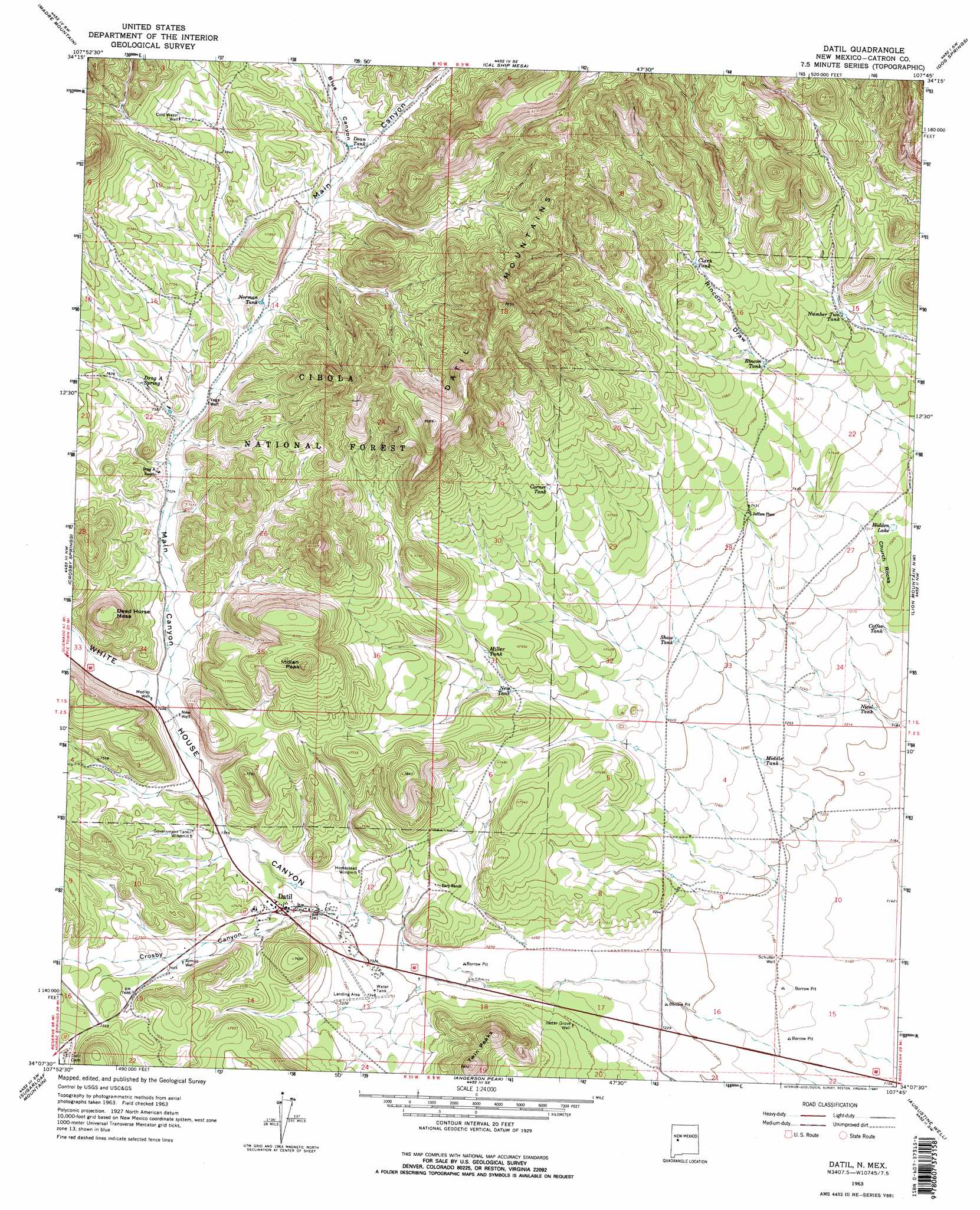
Datil Topo Map New Mexico
To zoom in, hover over the map of Datil
USGS Topo Quad 34107b7 - 1:24,000 scale
| Topo Map Name: | Datil |
| USGS Topo Quad ID: | 34107b7 |
| Print Size: | ca. 21 1/4" wide x 27" high |
| Southeast Coordinates: | 34.125° N latitude / 107.75° W longitude |
| Map Center Coordinates: | 34.1875° N latitude / 107.8125° W longitude |
| U.S. State: | NM |
| Filename: | o34107b7.jpg |
| Download Map JPG Image: | Datil topo map 1:24,000 scale |
| Map Type: | Topographic |
| Topo Series: | 7.5´ |
| Map Scale: | 1:24,000 |
| Source of Map Images: | United States Geological Survey (USGS) |
| Alternate Map Versions: |
Datil NM 1963, updated 1967 Download PDF Buy paper map Datil NM 1963, updated 1967 Download PDF Buy paper map Datil NM 1995, updated 1998 Download PDF Buy paper map Datil NM 2011 Download PDF Buy paper map Datil NM 2013 Download PDF Buy paper map Datil NM 2017 Download PDF Buy paper map |
| FStopo: | US Forest Service topo Datil is available: Download FStopo PDF Download FStopo TIF |
1:24,000 Topo Quads surrounding Datil
Tres Lagunas |
Third Canyon |
Pasture Canyon |
D Cross Mountain |
Table Mountain |
Red Flats |
Madre Mountain |
Cal Ship Mesa |
Dog Springs |
Indian Mesa |
Cox Peak |
Crosby Springs |
Datil |
Lion Mountain Nw |
Lion Mountain |
Log Canyon |
Sugarloaf Mountain |
Anderson Peak |
Augustine Well |
Arrowhead Well |
Horse Mountain East |
Luera Mountains Nw |
C-N Lake |
Kellog Well |
Monica Saddle |
> Back to 34107a1 at 1:100,000 scale
> Back to 34106a1 at 1:250,000 scale
> Back to U.S. Topo Maps home
Datil topo map: Gazetteer
Datil: Cliffs
Church Rocks elevation 2232m 7322′Datil: Lakes
Hidden Lake elevation 2231m 7319′Datil: Populated Places
Datil elevation 2251m 7385′Jeffers Place elevation 2259m 7411′
Datil: Post Offices
Datil Post Office elevation 2251m 7385′Datil: Reservoirs
Clark Tank elevation 2343m 7687′Coffee Tank elevation 2209m 7247′
Corner Tank elevation 2321m 7614′
Daniel Tank elevation 2282m 7486′
Dean Tank elevation 2362m 7749′
Double Tanks elevation 2362m 7749′
Middle Tank elevation 2208m 7244′
Miller Tank elevation 2285m 7496′
New Tank elevation 2265m 7431′
Nicol Tank elevation 2193m 7194′
Norman Tank elevation 2328m 7637′
Number Two Tank elevation 2290m 7513′
Rincon Tank elevation 2290m 7513′
Shaw Tank elevation 2239m 7345′
Datil: Springs
Drag A Spring elevation 2323m 7621′Norman Spring elevation 2335m 7660′
Datil: Summits
Dead Horse Mesa elevation 2418m 7933′Indian Peak elevation 2479m 8133′
Twin Peaks elevation 2390m 7841′
Wallace Hill elevation 2420m 7939′
Datil: Valleys
Blue Canyon elevation 2351m 7713′Crosby Canyon elevation 2228m 7309′
Main Canyon elevation 2262m 7421′
White House Canyon elevation 2227m 7306′
Datil: Wells
Armijo Well elevation 2266m 7434′Cedar Grove Well elevation 2227m 7306′
Cold Water Well elevation 2403m 7883′
Datil Water Well elevation 2263m 7424′
Medley Well elevation 2265m 7431′
New Well elevation 2264m 7427′
Schuller Well elevation 2189m 7181′
Vega Well elevation 2310m 7578′
Datil digital topo map on disk
Buy this Datil topo map showing relief, roads, GPS coordinates and other geographical features, as a high-resolution digital map file on DVD: