Riley Topo Map New Mexico
To zoom in, hover over the map of Riley
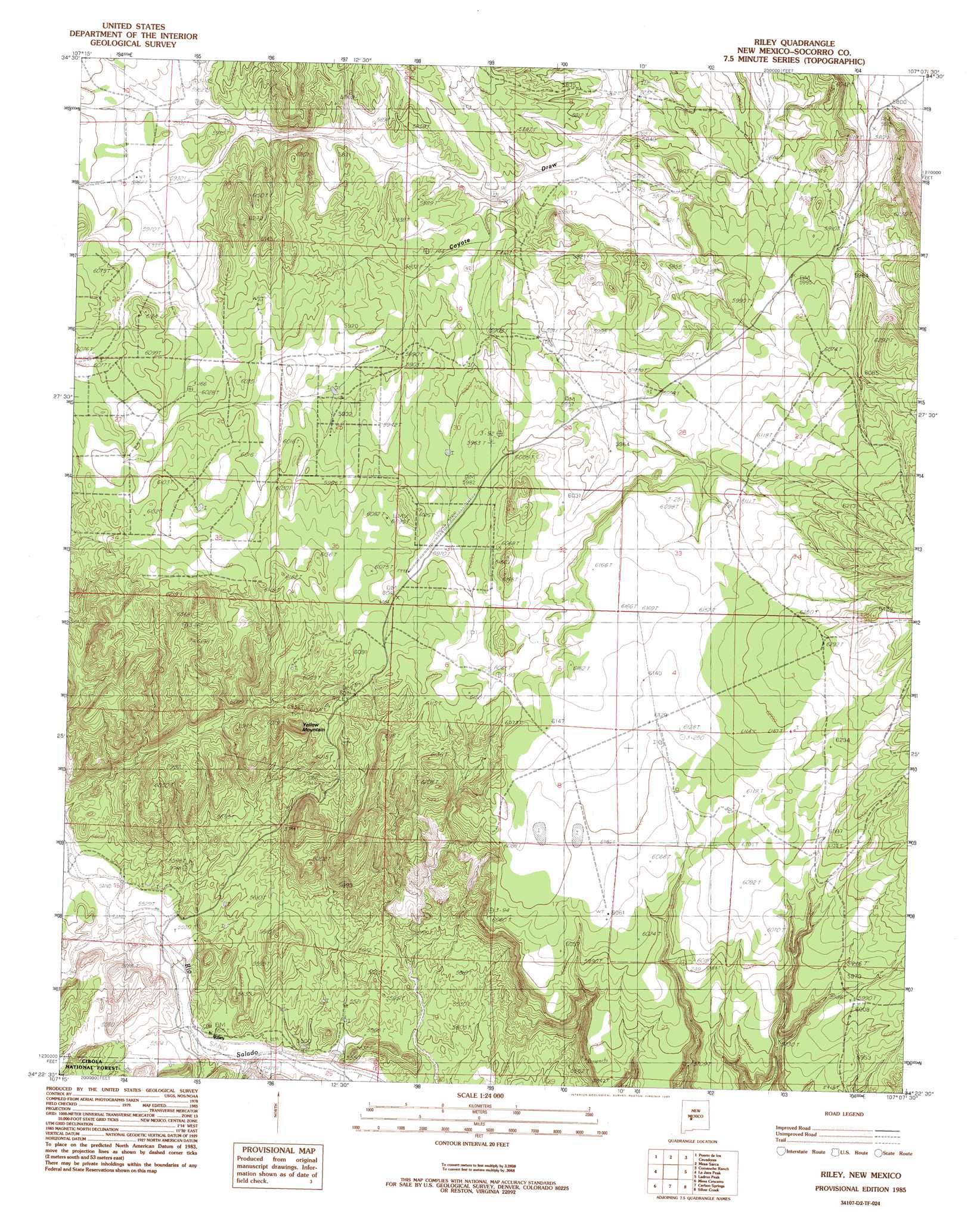
USGS Topo Quad 34107d2 - 1:24,000 scale
| Topo Map Name: | Riley |
| USGS Topo Quad ID: | 34107d2 |
| Print Size: | ca. 21 1/4" wide x 27" high |
| Southeast Coordinates: | 34.375° N latitude / 107.125° W longitude |
| Map Center Coordinates: | 34.4375° N latitude / 107.1875° W longitude |
| U.S. State: | NM |
| Filename: | o34107d2.jpg |
| Download Map JPG Image: | Riley topo map 1:24,000 scale |
| Map Type: | Topographic |
| Topo Series: | 7.5´ |
| Map Scale: | 1:24,000 |
| Source of Map Images: | United States Geological Survey (USGS) |
| Alternate Map Versions: |
Riley NM 1985, updated 1985 Download PDF Buy paper map Riley NM 1995, updated 1998 Download PDF Buy paper map Riley NM 2011 Download PDF Buy paper map Riley NM 2013 Download PDF Buy paper map Riley NM 2017 Download PDF Buy paper map |
| FStopo: | US Forest Service topo Riley is available: Download FStopo PDF Download FStopo TIF |
1:24,000 Topo Quads surrounding Riley
Cerro Del Oro |
Chicken Mountain |
Mesa Gallina |
Mesas Mojinas |
Belen Nw |
Field Ranch |
Puerto De Los Cavadores |
Mesa Sarca |
Comanche Ranch |
Belen Sw |
Puertecito |
La Jara Peak |
Riley |
Ladron Peak |
La Joya Nw |
Indian Spring Canyon |
Mesa Cencerro |
Carbon Springs |
Silver Creek |
San Acacia |
Gallinas Peak |
Silver Hill |
Granite Mountain |
San Lorenzo Spring |
Lemitar |
> Back to 34107a1 at 1:100,000 scale
> Back to 34106a1 at 1:250,000 scale
> Back to U.S. Topo Maps home
Riley topo map: Gazetteer
Riley: Mines
Brown elevation 1821m 5974′Romero elevation 1817m 5961′
Riley: Populated Places
Riley elevation 1677m 5501′Riley: Post Offices
Riley Post Office (historical) elevation 1677m 5501′Riley: Summits
Yellow Mountain elevation 1886m 6187′Riley: Valleys
Cañon del Tanque Hondo elevation 1677m 5501′Riley: Wells
RG 30314 Water Well elevation 1698m 5570′Riley digital topo map on disk
Buy this Riley topo map showing relief, roads, GPS coordinates and other geographical features, as a high-resolution digital map file on DVD: