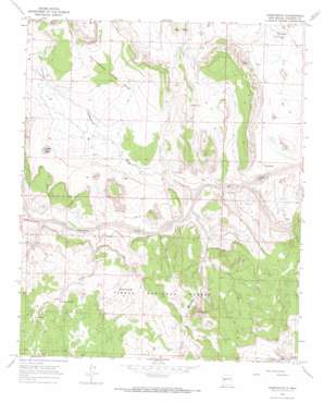
Puertecito Topo Map New Mexico
To zoom in, hover over the map of Puertecito
USGS Topo Quad 34107d4 - 1:24,000 scale
| Topo Map Name: | Puertecito |
| USGS Topo Quad ID: | 34107d4 |
| Print Size: | ca. 21 1/4" wide x 27" high |
| Southeast Coordinates: | 34.375° N latitude / 107.375° W longitude |
| Map Center Coordinates: | 34.4375° N latitude / 107.4375° W longitude |
| U.S. State: | NM |
| Filename: | o34107d4.jpg |
| Download Map JPG Image: | Puertecito topo map 1:24,000 scale |
| Map Type: | Topographic |
| Topo Series: | 7.5´ |
| Map Scale: | 1:24,000 |
| Source of Map Images: | United States Geological Survey (USGS) |
| Alternate Map Versions: |
Puertecito NM 1964, updated 1967 Download PDF Buy paper map Puertecito NM 1995, updated 1998 Download PDF Buy paper map Puertecito NM 2011 Download PDF Buy paper map Puertecito NM 2013 Download PDF Buy paper map Puertecito NM 2017 Download PDF Buy paper map |
| FStopo: | US Forest Service topo Puertecito is available: Download FStopo PDF Download FStopo TIF |
1:24,000 Topo Quads surrounding Puertecito
> Back to 34107a1 at 1:100,000 scale
> Back to 34106a1 at 1:250,000 scale
> Back to U.S. Topo Maps home
Puertecito topo map: Gazetteer
Puertecito: Populated Places
John Padilla Settlement elevation 1935m 6348′Puertecito elevation 1793m 5882′
Puertecito: Post Offices
Puertecito Post Office (historical) elevation 1793m 5882′Puertecito: Springs
Alamo Spring elevation 1895m 6217′Richard Spring elevation 1861m 6105′
Puertecito: Streams
Alamo Creek elevation 1829m 6000′Chavez Creek elevation 1860m 6102′
Jaralosa Creek elevation 1806m 5925′
Puertecito: Summits
Cottonwood Draw Mesa elevation 1983m 6505′La Cruz Peak elevation 2035m 6676′
White Peak elevation 1978m 6489′
Puertecito: Valleys
Abbe Spring Canyon elevation 1883m 6177′Cottonwood Draw elevation 1800m 5905′
Puertecito: Wells
26-15-1 Water Well elevation 1900m 6233′26-17-1 Water Well elevation 1853m 6079′
26-9-1 Water Well elevation 1879m 6164′
A-5 Water Well elevation 1862m 6108′
A-6 Water Well elevation 1827m 5994′
A-8 Water Well elevation 1929m 6328′
Apache Well elevation 1917m 6289′
Bill Dobbs Well elevation 1792m 5879′
Chavez Water Well elevation 1893m 6210′
Piezomet 1 Water Well elevation 1812m 5944′
Piezomet 2 Water Well elevation 1820m 5971′
Pino Water Well elevation 1831m 6007′
Puertecito digital topo map on disk
Buy this Puertecito topo map showing relief, roads, GPS coordinates and other geographical features, as a high-resolution digital map file on DVD:


