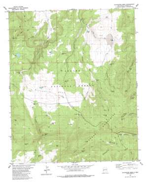
Slaughter Mesa Topo Map New Mexico
To zoom in, hover over the map of Slaughter Mesa
USGS Topo Quad 34108a4 - 1:24,000 scale
| Topo Map Name: | Slaughter Mesa |
| USGS Topo Quad ID: | 34108a4 |
| Print Size: | ca. 21 1/4" wide x 27" high |
| Southeast Coordinates: | 34° N latitude / 108.375° W longitude |
| Map Center Coordinates: | 34.0625° N latitude / 108.4375° W longitude |
| U.S. State: | NM |
| Filename: | o34108a4.jpg |
| Download Map JPG Image: | Slaughter Mesa topo map 1:24,000 scale |
| Map Type: | Topographic |
| Topo Series: | 7.5´ |
| Map Scale: | 1:24,000 |
| Source of Map Images: | United States Geological Survey (USGS) |
| Alternate Map Versions: |
Slaughter Mesa NM 1981, updated 1981 Download PDF Buy paper map Slaughter Mesa NM 1999, updated 2002 Download PDF Buy paper map Slaughter Mesa NM 2011 Download PDF Buy paper map Slaughter Mesa NM 2013 Download PDF Buy paper map Slaughter Mesa NM 2017 Download PDF Buy paper map |
| FStopo: | US Forest Service topo Slaughter Mesa is available: Download FStopo PDF Download FStopo TIF |
1:24,000 Topo Quads surrounding Slaughter Mesa
> Back to 34108a1 at 1:100,000 scale
> Back to 34108a1 at 1:250,000 scale
> Back to U.S. Topo Maps home
Slaughter Mesa topo map: Gazetteer
Slaughter Mesa: Basins
Lake Pit elevation 2586m 8484′Slaughter Mesa: Lakes
El Caso Lake elevation 2620m 8595′Slaughter Mesa: Ranges
Mangas Mountains elevation 2633m 8638′Slaughter Mesa: Reservoirs
Antelope Tank elevation 2549m 8362′Bluestem Tank elevation 2495m 8185′
Bull Tank elevation 2558m 8392′
Caballeriza Tank elevation 2514m 8248′
Cat Spring Tank elevation 2699m 8854′
Continental Tank elevation 2558m 8392′
Divide Tank elevation 2538m 8326′
East Tank elevation 2453m 8047′
Elk Tank elevation 2457m 8061′
Fire Tank elevation 2579m 8461′
Gooseberry Pit elevation 2453m 8047′
Green Tank elevation 2441m 8008′
Hell Hole Tank elevation 2446m 8024′
Indio Canyon Tank elevation 2590m 8497′
Jacobs Camp Tank elevation 2535m 8316′
Largo Canyon Tank elevation 2597m 8520′
Lobo Tank elevation 2509m 8231′
McKibben Tank elevation 2608m 8556′
Mestenio Tank elevation 2467m 8093′
North Tank elevation 2471m 8106′
San Antone Tank elevation 2654m 8707′
Slaughter Mesa Tank elevation 2663m 8736′
Slaughter Mesa: Springs
Caballeriza Spring elevation 2573m 8441′Cassidera Spring elevation 2605m 8546′
Cat Spring elevation 2718m 8917′
Chimenea Spring elevation 2655m 8710′
Cooper Seep Spring elevation 2632m 8635′
Leslie Spring elevation 2402m 7880′
Lyles Camp Spring elevation 2561m 8402′
Salvador Spring elevation 2575m 8448′
Twin Springs elevation 2625m 8612′
Verde Spring elevation 2587m 8487′
Slaughter Mesa: Summits
Slaughter Mesa elevation 2671m 8763′Slaughter Mesa: Trails
Leslie Spring Trail elevation 2395m 7857′Slaughter Mesa: Valleys
Chimenea Canyon elevation 2536m 8320′Dead Horse Canyon elevation 2532m 8307′
Largo Canyon elevation 2378m 7801′
Salvador Canyon elevation 2467m 8093′
Slaughter Mesa: Wells
Dry Lake Well elevation 2499m 8198′Lost Cabin Well elevation 2362m 7749′
Slaughter Mesa digital topo map on disk
Buy this Slaughter Mesa topo map showing relief, roads, GPS coordinates and other geographical features, as a high-resolution digital map file on DVD:


