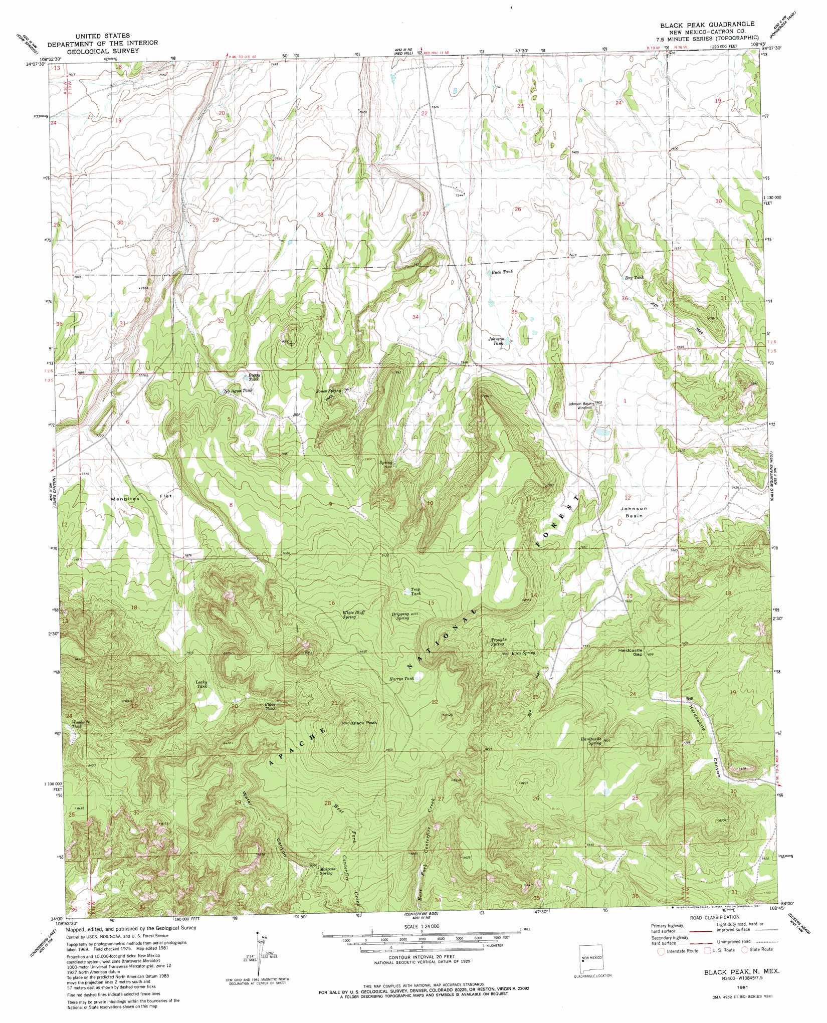
Black Peak Topo Map New Mexico
To zoom in, hover over the map of Black Peak
USGS Topo Quad 34108a7 - 1:24,000 scale
| Topo Map Name: | Black Peak |
| USGS Topo Quad ID: | 34108a7 |
| Print Size: | ca. 21 1/4" wide x 27" high |
| Southeast Coordinates: | 34° N latitude / 108.75° W longitude |
| Map Center Coordinates: | 34.0625° N latitude / 108.8125° W longitude |
| U.S. State: | NM |
| Filename: | o34108a7.jpg |
| Download Map JPG Image: | Black Peak topo map 1:24,000 scale |
| Map Type: | Topographic |
| Topo Series: | 7.5´ |
| Map Scale: | 1:24,000 |
| Source of Map Images: | United States Geological Survey (USGS) |
| Alternate Map Versions: |
Black Peak NM 1999, updated 2002 Download PDF Buy paper map Black Peak NM 2011 Download PDF Buy paper map Black Peak NM 2013 Download PDF Buy paper map Black Peak NM 2017 Download PDF Buy paper map |
| FStopo: | US Forest Service topo Black Peak is available: Download FStopo PDF Download FStopo TIF |
1:24,000 Topo Quads surrounding Black Peak
The Rincon |
Goat Spring |
Blaines Lake |
Tejana Mesa Sw |
Armstrong Canyon |
Nelson Reservoir Ne |
Cow Springs |
Red Hill |
Pondersoa Tank |
Largo Mesa |
Loco Knoll |
Jones Canyon |
Black Peak |
Gallo Mountains West |
Gallo Mountains East |
Escudilla Mountain |
Underwood Lake |
Centerfire Bog |
Queens Head |
Aragon |
Luna Lake |
Luna |
Dillon Mountain |
Cruzville |
Squirrel Springs Canyon |
> Back to 34108a1 at 1:100,000 scale
> Back to 34108a1 at 1:250,000 scale
> Back to U.S. Topo Maps home
Black Peak topo map: Gazetteer
Black Peak: Basins
Johnson Basin elevation 2300m 7545′Johnson Basin elevation 2309m 7575′
Black Peak: Flats
Mangitas Flat elevation 2377m 7798′Black Peak: Gaps
Harcastle Gap elevation 2393m 7851′Black Peak: Reservoirs
Black Tank elevation 2495m 8185′Boggy Tank elevation 2371m 7778′
Buck Tank elevation 2249m 7378′
Dry Tank elevation 2288m 7506′
Gully Tank elevation 2349m 7706′
Harrys Tank elevation 2567m 8421′
Johnson Tank elevation 2255m 7398′
Juniper Tank elevation 2388m 7834′
Leaky Tank elevation 2447m 8028′
Mangitas Storage Tank elevation 2423m 7949′
Mullen Tank elevation 2315m 7595′
No Agua Tank elevation 2373m 7785′
Ridge Tank elevation 2477m 8126′
Trap Tank elevation 2490m 8169′
Water Canyon Tank elevation 2479m 8133′
Woodside Tank elevation 2511m 8238′
Black Peak: Springs
Baca Spring elevation 2401m 7877′Dripping Spring elevation 2513m 8244′
Hardcastle Spring elevation 2385m 7824′
Higbsib Basub Soprubg elevation 2291m 7516′
Johnson Basin Spring elevation 2291m 7516′
Jones Spring elevation 2323m 7621′
Malpais Spring elevation 2469m 8100′
Troughs Spring elevation 2414m 7919′
White Bluff Spring elevation 2529m 8297′
Black Peak: Summits
Black Peak elevation 2745m 9005′Black Peak: Valleys
Renfro Canyon elevation 2306m 7565′Steel Canyon elevation 2316m 7598′
Black Peak: Wells
Hardcastle Well elevation 2349m 7706′Black Peak digital topo map on disk
Buy this Black Peak topo map showing relief, roads, GPS coordinates and other geographical features, as a high-resolution digital map file on DVD: