Pie Town Topo Map New Mexico
To zoom in, hover over the map of Pie Town
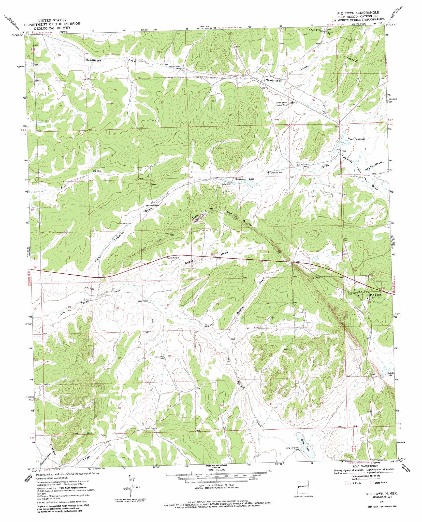
USGS Topo Quad 34108c2 - 1:24,000 scale
| Topo Map Name: | Pie Town |
| USGS Topo Quad ID: | 34108c2 |
| Print Size: | ca. 21 1/4" wide x 27" high |
| Southeast Coordinates: | 34.25° N latitude / 108.125° W longitude |
| Map Center Coordinates: | 34.3125° N latitude / 108.1875° W longitude |
| U.S. State: | NM |
| Filename: | o34108c2.jpg |
| Download Map JPG Image: | Pie Town topo map 1:24,000 scale |
| Map Type: | Topographic |
| Topo Series: | 7.5´ |
| Map Scale: | 1:24,000 |
| Source of Map Images: | United States Geological Survey (USGS) |
| Alternate Map Versions: |
Pie Town NM 1967, updated 1971 Download PDF Buy paper map Pie Town NM 1967, updated 1986 Download PDF Buy paper map Pie Town NM 2010 Download PDF Buy paper map Pie Town NM 2013 Download PDF Buy paper map Pie Town NM 2017 Download PDF Buy paper map |
1:24,000 Topo Quads surrounding Pie Town
Techado |
Veteado Mountain |
Trail Lake |
York Ranch Se |
Bonine Canyon |
Mariano Springs |
Adams Diggings |
Blue Hills |
Tres Lagunas |
Third Canyon |
Quemado |
Omega |
Pie Town |
Red Flats |
Madre Mountain |
Escondido Mountains |
Mangas |
Alegres Mountain |
Cox Peak |
Crosby Springs |
Slaughter Mesa |
Mangas Mountain |
Wallace Mesa |
Log Canyon |
Sugarloaf Mountain |
> Back to 34108a1 at 1:100,000 scale
> Back to 34108a1 at 1:250,000 scale
> Back to U.S. Topo Maps home
Pie Town topo map: Gazetteer
Pie Town: Airports
Nalda Ranch Airport elevation 2288m 7506′Pie Town: Flats
Tingle Flats elevation 2291m 7516′Pie Town: Lakes
Long Lake elevation 2274m 7460′Tres Lagunas elevation 2285m 7496′
Pie Town: Populated Places
Pie Town elevation 2369m 7772′Pie Town: Post Offices
Pie Town Post Office elevation 2369m 7772′Pie Town: Reservoirs
Santianez Lake elevation 2274m 7460′Pie Town: Ridges
Top of the World elevation 2323m 7621′Pie Town: Valleys
Chavez Draw elevation 2228m 7309′Pancake Draw elevation 2269m 7444′
Payne Draw elevation 2288m 7506′
Tres Lagunas Draw elevation 2219m 7280′
Wyche Draw elevation 2244m 7362′
Pie Town: Wells
Bols Well elevation 2253m 7391′Bull Pasture Well elevation 2277m 7470′
Chamiso Well elevation 2274m 7460′
Electric Well elevation 2264m 7427′
Lake Well elevation 2274m 7460′
Long Lake Well elevation 2276m 7467′
North Well elevation 2249m 7378′
Seeps Well elevation 2243m 7358′
Upper Well elevation 2233m 7326′
Wade Well elevation 2243m 7358′
Pie Town digital topo map on disk
Buy this Pie Town topo map showing relief, roads, GPS coordinates and other geographical features, as a high-resolution digital map file on DVD: