Armstrong Canyon Topo Map New Mexico
To zoom in, hover over the map of Armstrong Canyon
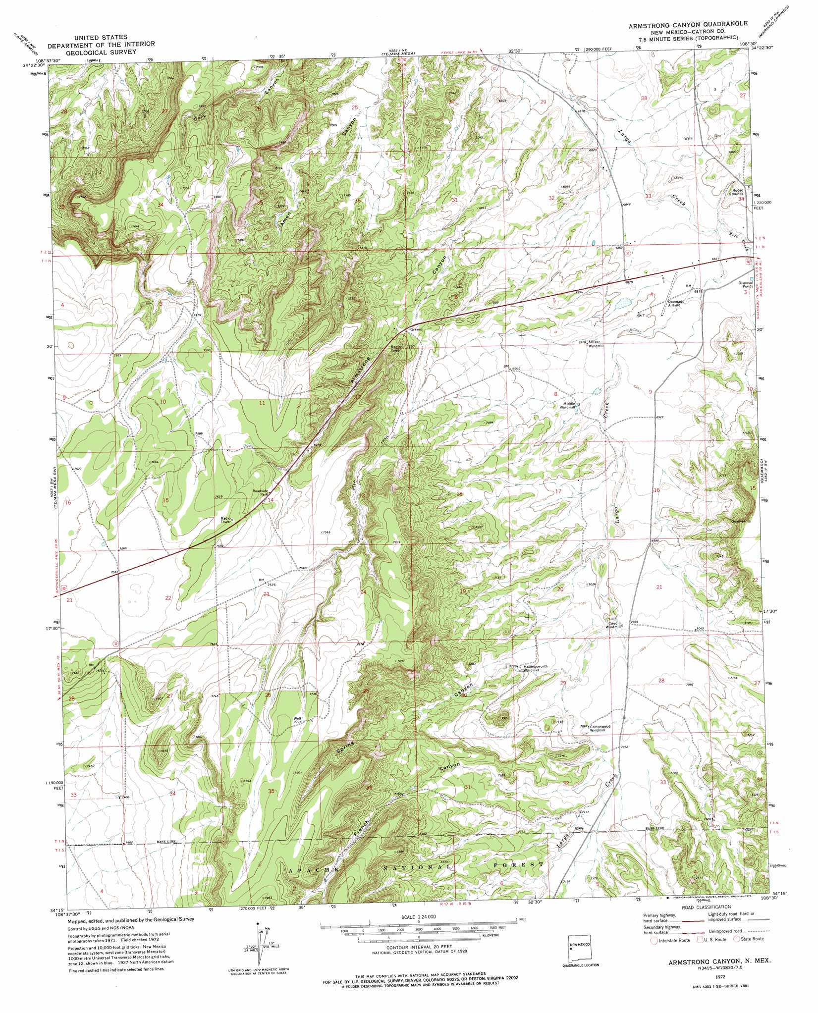
USGS Topo Quad 34108c5 - 1:24,000 scale
| Topo Map Name: | Armstrong Canyon |
| USGS Topo Quad ID: | 34108c5 |
| Print Size: | ca. 21 1/4" wide x 27" high |
| Southeast Coordinates: | 34.25° N latitude / 108.5° W longitude |
| Map Center Coordinates: | 34.3125° N latitude / 108.5625° W longitude |
| U.S. State: | NM |
| Filename: | o34108c5.jpg |
| Download Map JPG Image: | Armstrong Canyon topo map 1:24,000 scale |
| Map Type: | Topographic |
| Topo Series: | 7.5´ |
| Map Scale: | 1:24,000 |
| Source of Map Images: | United States Geological Survey (USGS) |
| Alternate Map Versions: |
Armstrong Canyon NM 1972, updated 1976 Download PDF Buy paper map Armstrong Canyon NM 1999, updated 2002 Download PDF Buy paper map Armstrong Canyon NM 2011 Download PDF Buy paper map Armstrong Canyon NM 2013 Download PDF Buy paper map Armstrong Canyon NM 2017 Download PDF Buy paper map |
| FStopo: | US Forest Service topo Armstrong Canyon is available: Download FStopo PDF Download FStopo TIF |
1:24,000 Topo Quads surrounding Armstrong Canyon
Moreno Hill |
Fence Lake Sw |
Cerro Prieto |
Techado |
Veteado Mountain |
Zuni Salt Lake |
Lake Armijo |
Tejana Mesa |
Mariano Springs |
Adams Diggings |
Blaines Lake |
Tejana Mesa Sw |
Armstrong Canyon |
Quemado |
Omega |
Red Hill |
Pondersoa Tank |
Largo Mesa |
Escondido Mountains |
Mangas |
Black Peak |
Gallo Mountains West |
Gallo Mountains East |
Slaughter Mesa |
Mangas Mountain |
> Back to 34108a1 at 1:100,000 scale
> Back to 34108a1 at 1:250,000 scale
> Back to U.S. Topo Maps home
Armstrong Canyon topo map: Gazetteer
Armstrong Canyon: Airports
Quemado Airport elevation 2098m 6883′Armstrong Canyon: Reservoirs
North Tank elevation 2295m 7529′Armstrong Canyon: Streams
Rito Creek elevation 2089m 6853′Armstrong Canyon: Valleys
Armstrong Canyon elevation 2073m 6801′Cañon del Leon elevation 2182m 7158′
French Canyon elevation 2155m 7070′
Spring Canyon elevation 2141m 7024′
Armstrong Canyon: Wells
Hay Canyon Well elevation 2326m 7631′Armstrong Canyon digital topo map on disk
Buy this Armstrong Canyon topo map showing relief, roads, GPS coordinates and other geographical features, as a high-resolution digital map file on DVD: