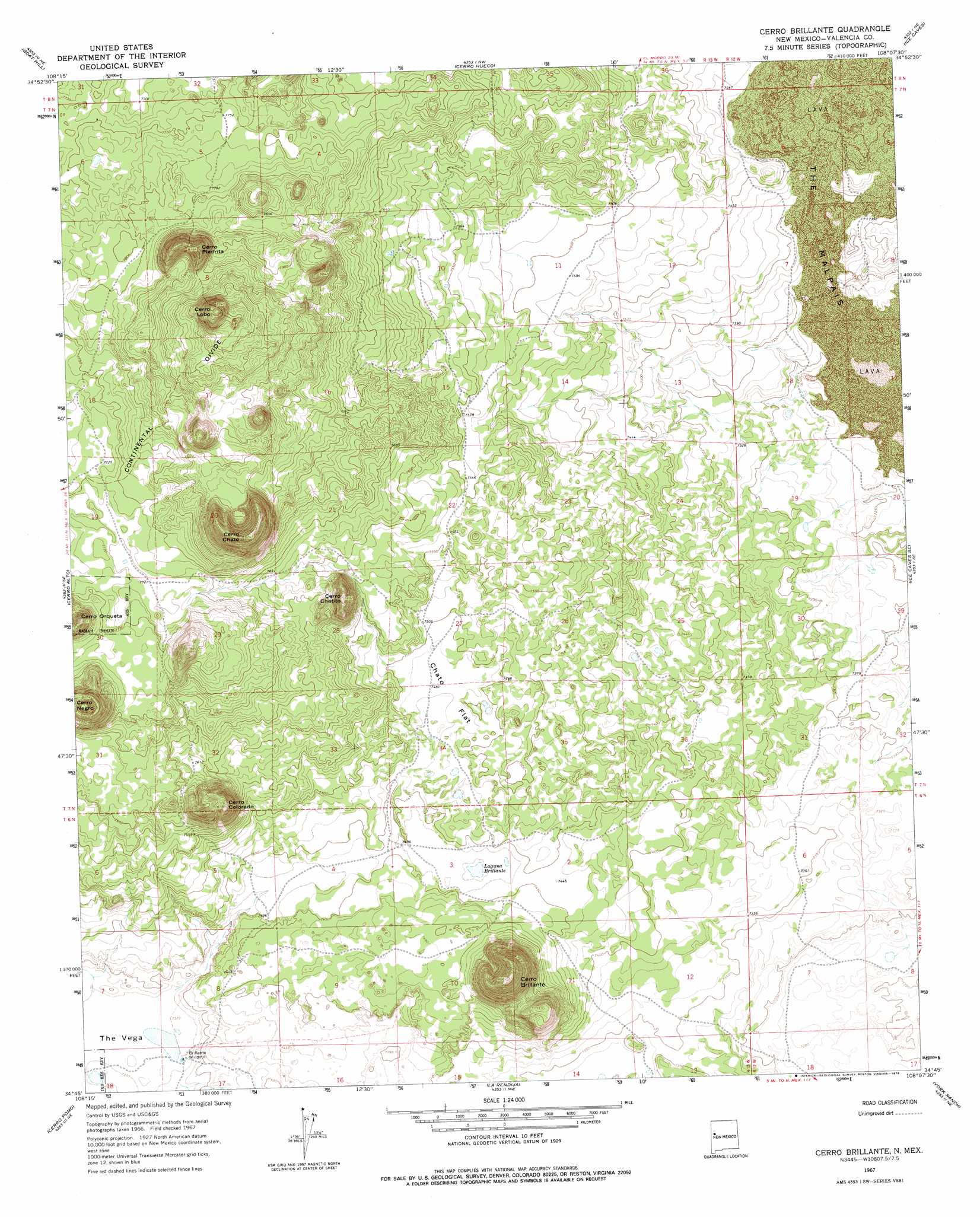
Cerro Brilliante Topo Map New Mexico
To zoom in, hover over the map of Cerro Brilliante
USGS Topo Quad 34108g2 - 1:24,000 scale
| Topo Map Name: | Cerro Brilliante |
| USGS Topo Quad ID: | 34108g2 |
| Print Size: | ca. 21 1/4" wide x 27" high |
| Southeast Coordinates: | 34.75° N latitude / 108.125° W longitude |
| Map Center Coordinates: | 34.8125° N latitude / 108.1875° W longitude |
| U.S. State: | NM |
| Filename: | o34108g2.jpg |
| Download Map JPG Image: | Cerro Brilliante topo map 1:24,000 scale |
| Map Type: | Topographic |
| Topo Series: | 7.5´ |
| Map Scale: | 1:24,000 |
| Source of Map Images: | United States Geological Survey (USGS) |
| Alternate Map Versions: |
Cerro Brillante NM 1967, updated 1971 Download PDF Buy paper map Cerro Brillante NM 1967, updated 1978 Download PDF Buy paper map Cerro Brillante NM 2010 Download PDF Buy paper map Cerro Brillante NM 2013 Download PDF Buy paper map Cerro Brillante NM 2017 Download PDF Buy paper map |
1:24,000 Topo Quads surrounding Cerro Brilliante
Togeye Lake |
El Morro |
Valle Largo |
Paxton Springs |
San Rafael |
Nicoll Lake |
Goat Hill |
Cerro Hueco |
Ice Caves |
Arrosa Ranch |
Red Lake Mission |
Cerro Alto |
Cerro Brilliante |
Ice Caves Se |
North Pasture |
Chimney Hill |
Cerro Pomo |
La Rendija |
York Ranch |
Sand Canyon |
Techado |
Veteado Mountain |
Trail Lake |
York Ranch Se |
Bonine Canyon |
> Back to 34108e1 at 1:100,000 scale
> Back to 34108a1 at 1:250,000 scale
> Back to U.S. Topo Maps home
Cerro Brilliante topo map: Gazetteer
Cerro Brilliante: Areas
The Vega elevation 2249m 7378′Cerro Brilliante: Flats
Chato Flat elevation 2281m 7483′Cerro Brilliante: Lakes
Laguna Brillante elevation 2265m 7431′Cerro Brilliante: Parks
Chain-of-Craters Wilderness Study Area elevation 2394m 7854′Cerro Brilliante: Summits
Cerro Brillante elevation 2440m 8005′Cerro Chatito elevation 2397m 7864′
Cerro Chato elevation 2504m 8215′
Cerro Colorada elevation 2401m 7877′
Cerro Lobo elevation 2527m 8290′
Cerro Negro elevation 2460m 8070′
Cerro Orqueta elevation 2438m 7998′
Cerro Piedrita elevation 2484m 8149′
Cerro Brilliante digital topo map on disk
Buy this Cerro Brilliante topo map showing relief, roads, GPS coordinates and other geographical features, as a high-resolution digital map file on DVD: