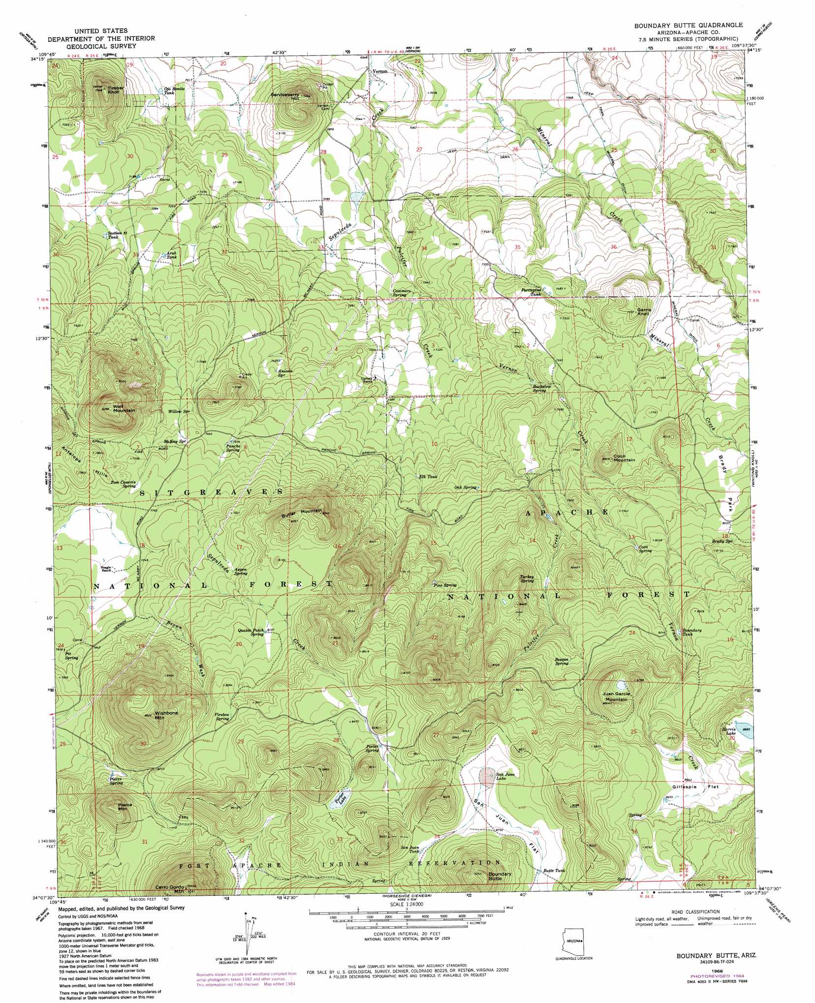
Boundary Butte Topo Map Arizona
To zoom in, hover over the map of Boundary Butte
USGS Topo Quad 34109b6 - 1:24,000 scale
| Topo Map Name: | Boundary Butte |
| USGS Topo Quad ID: | 34109b6 |
| Print Size: | ca. 21 1/4" wide x 27" high |
| Southeast Coordinates: | 34.125° N latitude / 109.625° W longitude |
| Map Center Coordinates: | 34.1875° N latitude / 109.6875° W longitude |
| U.S. State: | AZ |
| Filename: | o34109b6.jpg |
| Download Map JPG Image: | Boundary Butte topo map 1:24,000 scale |
| Map Type: | Topographic |
| Topo Series: | 7.5´ |
| Map Scale: | 1:24,000 |
| Source of Map Images: | United States Geological Survey (USGS) |
| Alternate Map Versions: |
Boundary Butte AZ 1968, updated 1972 Download PDF Buy paper map Boundary Butte AZ 1968, updated 1973 Download PDF Buy paper map Boundary Butte AZ 1968, updated 1985 Download PDF Buy paper map Boundary Butte AZ 1998, updated 2000 Download PDF Buy paper map Boundary Butte AZ 2011 Download PDF Buy paper map Boundary Butte AZ 2014 Download PDF Buy paper map |
| FStopo: | US Forest Service topo Boundary Butte is available: Download FStopo PDF Download FStopo TIF |
1:24,000 Topo Quads surrounding Boundary Butte
Mesa Redonda Nw |
Mesa Redonda |
Concho Lake |
Concho |
Salado |
Silver Springs |
Ortega Mountain |
Vernon |
Cerro Hueco |
Lyman Lake Sw |
Lakeside |
Sponseller Mountain |
Boundary Butte |
Whiting Knoll |
Springerville Nw |
Indian Pine |
Mcnary |
Horseshoe Cienega |
Greens Peak |
Greer |
Alchesay Flat |
Hawley Lake West |
Hawley Lake East |
Mount Baldy |
Big Lake North |
> Back to 34109a1 at 1:100,000 scale
> Back to 34108a1 at 1:250,000 scale
> Back to U.S. Topo Maps home
Boundary Butte topo map: Gazetteer
Boundary Butte: Basins
Aniceto Cinder Pit elevation 2293m 7522′Boundary Butte: Canals
Mineral Ditch elevation 2231m 7319′Boundary Butte: Flats
Brady Park elevation 2430m 7972′Gillespie Flat elevation 2634m 8641′
San Juan Flat elevation 2665m 8743′
Boundary Butte: Lakes
Harris Lake elevation 2648m 8687′Porter Lake elevation 2607m 8553′
San Juan Lake elevation 2659m 8723′
Boundary Butte: Reservoirs
Aniceto Tank elevation 2266m 7434′Arab Tank elevation 2231m 7319′
Bear Tank elevation 2631m 8631′
Bosque Tank elevation 2526m 8287′
Boundary Spring Tank elevation 2434m 7985′
Boundary Tank elevation 2434m 7985′
Boundary Tanks elevation 2497m 8192′
Butler Tak elevation 2275m 7463′
Butte Tank elevation 2669m 8756′
Circle Tank elevation 2276m 7467′
Elk Tank elevation 2296m 7532′
Gillepie Tank elevation 2640m 8661′
Gust Reservoir elevation 2373m 7785′
Jog Tank elevation 2201m 7221′
Lee Tank elevation 2262m 7421′
Naegle Tank elevation 2360m 7742′
Ojo Bonito Tank elevation 2142m 7027′
Pancho Spring elevation 2336m 7664′
Pancho Tank elevation 2335m 7660′
Pine Spring elevation 2440m 8005′
Porcupine Tank elevation 2275m 7463′
Private Tank elevation 2146m 7040′
San Juan Tanks elevation 2647m 8684′
Section Six Tank elevation 2223m 7293′
Section Thirty Tank elevation 2213m 7260′
Section Twenty Tank elevation 2451m 8041′
Section Twenty Tank elevation 2450m 8038′
Boundary Butte: Springs
Aniceto Spring elevation 2274m 7460′Aspen Spring elevation 2422m 7946′
Bosque Spring elevation 2536m 8320′
Brady Spring elevation 2462m 8077′
Buckelew Spring elevation 2282m 7486′
Casimero Spring elevation 2189m 7181′
Coon Spring elevation 2437m 7995′
Firebox Spring elevation 2527m 8290′
Gillespie Spring elevation 2274m 7460′
Goodman Spring elevation 2268m 7440′
Gust Spring elevation 2436m 7992′
Lee Spring elevation 2274m 7460′
McKay Spring elevation 2342m 7683′
Oak Spring elevation 2347m 7700′
Pancho Spring elevation 2338m 7670′
Pierce Spring elevation 2464m 8083′
Pine Spring elevation 2443m 8015′
Pit Spring elevation 2398m 7867′
Porter Spring elevation 2588m 8490′
Quakie Patch Spring elevation 2476m 8123′
Silver Spring elevation 2630m 8628′
Tom Canovis Spring elevation 2357m 7732′
Turkey Spring elevation 2455m 8054′
Willow Spring elevation 2323m 7621′
Boundary Butte: Streams
Brown Wash elevation 2401m 7877′Pulcifer Creek elevation 2140m 7020′
Vernon Creek elevation 2193m 7194′
Boundary Butte: Summits
Aniceto Knoll elevation 2355m 7726′Antelope Hills elevation 2408m 7900′
Boundary Butte elevation 2815m 9235′
Butler Mountain elevation 2549m 8362′
Cerro Gordon Mountain elevation 2781m 9124′
Coon Mountain elevation 2439m 8001′
Garris Knoll elevation 2358m 7736′
Juan Garcia Mountain elevation 2684m 8805′
Pierce Mountain elevation 2464m 8083′
Serviceberry Hill elevation 2270m 7447′
Timber Knoll elevation 2294m 7526′
Wishbone Mountain elevation 2690m 8825′
Wolf Mountain elevation 2525m 8284′
Boundary Butte digital topo map on disk
Buy this Boundary Butte topo map showing relief, roads, GPS coordinates and other geographical features, as a high-resolution digital map file on DVD: