Cerro Hueco Topo Map Arizona
To zoom in, hover over the map of Cerro Hueco
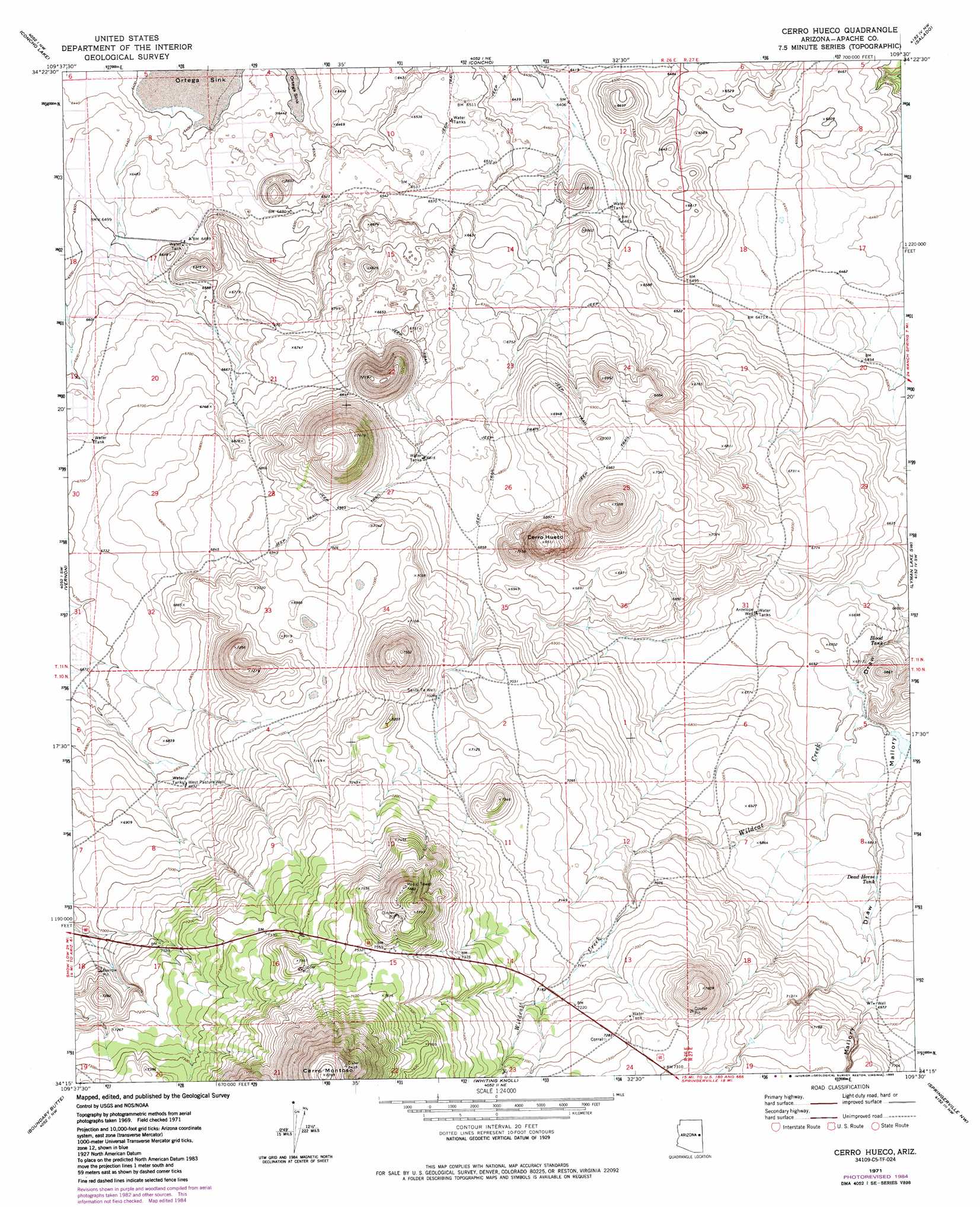
USGS Topo Quad 34109c5 - 1:24,000 scale
| Topo Map Name: | Cerro Hueco |
| USGS Topo Quad ID: | 34109c5 |
| Print Size: | ca. 21 1/4" wide x 27" high |
| Southeast Coordinates: | 34.25° N latitude / 109.5° W longitude |
| Map Center Coordinates: | 34.3125° N latitude / 109.5625° W longitude |
| U.S. State: | AZ |
| Filename: | o34109c5.jpg |
| Download Map JPG Image: | Cerro Hueco topo map 1:24,000 scale |
| Map Type: | Topographic |
| Topo Series: | 7.5´ |
| Map Scale: | 1:24,000 |
| Source of Map Images: | United States Geological Survey (USGS) |
| Alternate Map Versions: |
Cerro Hueco AZ 1971, updated 1973 Download PDF Buy paper map Cerro Hueco AZ 1971, updated 1985 Download PDF Buy paper map Cerro Hueco AZ 2011 Download PDF Buy paper map Cerro Hueco AZ 2014 Download PDF Buy paper map |
1:24,000 Topo Quads surrounding Cerro Hueco
Manuel Seep |
Hunt |
Stinking Springs |
Zion Reservoir |
Saint Johns North |
Mesa Redonda |
Concho Lake |
Concho |
Salado |
Saint Johns South |
Ortega Mountain |
Vernon |
Cerro Hueco |
Lyman Lake Sw |
Lyman Lake |
Sponseller Mountain |
Boundary Butte |
Whiting Knoll |
Springerville Nw |
Springerville |
Mcnary |
Horseshoe Cienega |
Greens Peak |
Greer |
Eagar |
> Back to 34109a1 at 1:100,000 scale
> Back to 34108a1 at 1:250,000 scale
> Back to U.S. Topo Maps home
Cerro Hueco topo map: Gazetteer
Cerro Hueco: Reservoirs
Blood Tank elevation 2009m 6591′Dead Horse Tank elevation 2080m 6824′
Cerro Hueco: Streams
Wildcat Creek elevation 2032m 6666′Cerro Hueco: Summits
Cerro Hueco elevation 1986m 6515′Cerro Montoso elevation 2570m 8431′
Cerro Hueco: Wells
Antelope Well elevation 2036m 6679′Santa Fe Well elevation 0m 0′
West Pasture Well elevation 2085m 6840′
Cerro Hueco digital topo map on disk
Buy this Cerro Hueco topo map showing relief, roads, GPS coordinates and other geographical features, as a high-resolution digital map file on DVD: