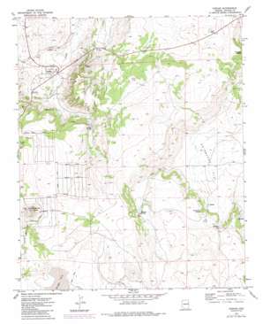
Concho Topo Map Arizona
To zoom in, hover over the map of Concho
USGS Topo Quad 34109d5 - 1:24,000 scale
| Topo Map Name: | Concho |
| USGS Topo Quad ID: | 34109d5 |
| Print Size: | ca. 21 1/4" wide x 27" high |
| Southeast Coordinates: | 34.375° N latitude / 109.5° W longitude |
| Map Center Coordinates: | 34.4375° N latitude / 109.5625° W longitude |
| U.S. State: | AZ |
| Filename: | o34109d5.jpg |
| Download Map JPG Image: | Concho topo map 1:24,000 scale |
| Map Type: | Topographic |
| Topo Series: | 7.5´ |
| Map Scale: | 1:24,000 |
| Source of Map Images: | United States Geological Survey (USGS) |
| Alternate Map Versions: |
Concho AZ 1971, updated 1973 Download PDF Buy paper map Concho AZ 1971, updated 1984 Download PDF Buy paper map Concho AZ 2011 Download PDF Buy paper map Concho AZ 2014 Download PDF Buy paper map |
1:24,000 Topo Quads surrounding Concho
> Back to 34109a1 at 1:100,000 scale
> Back to 34108a1 at 1:250,000 scale
> Back to U.S. Topo Maps home
Concho topo map: Gazetteer
Concho: Basins
Ortega Sink elevation 1949m 6394′Concho: Dams
Concho Springs Dam elevation 1954m 6410′Concho: Flats
Swinburne Flat elevation 1822m 5977′Concho: Populated Places
Concho elevation 1811m 5941′Concho: Springs
Hamblin Spring elevation 1878m 6161′Malpais Spring elevation 1887m 6190′
Ortega Spring elevation 1878m 6161′
Schuster Spring elevation 0m 0′
Swinburne Spring elevation 1877m 6158′
Concho: Summits
Concho Spring Knoll elevation 2049m 6722′Concho digital topo map on disk
Buy this Concho topo map showing relief, roads, GPS coordinates and other geographical features, as a high-resolution digital map file on DVD:


