Little Milky Wash Topo Map Arizona
To zoom in, hover over the map of Little Milky Wash
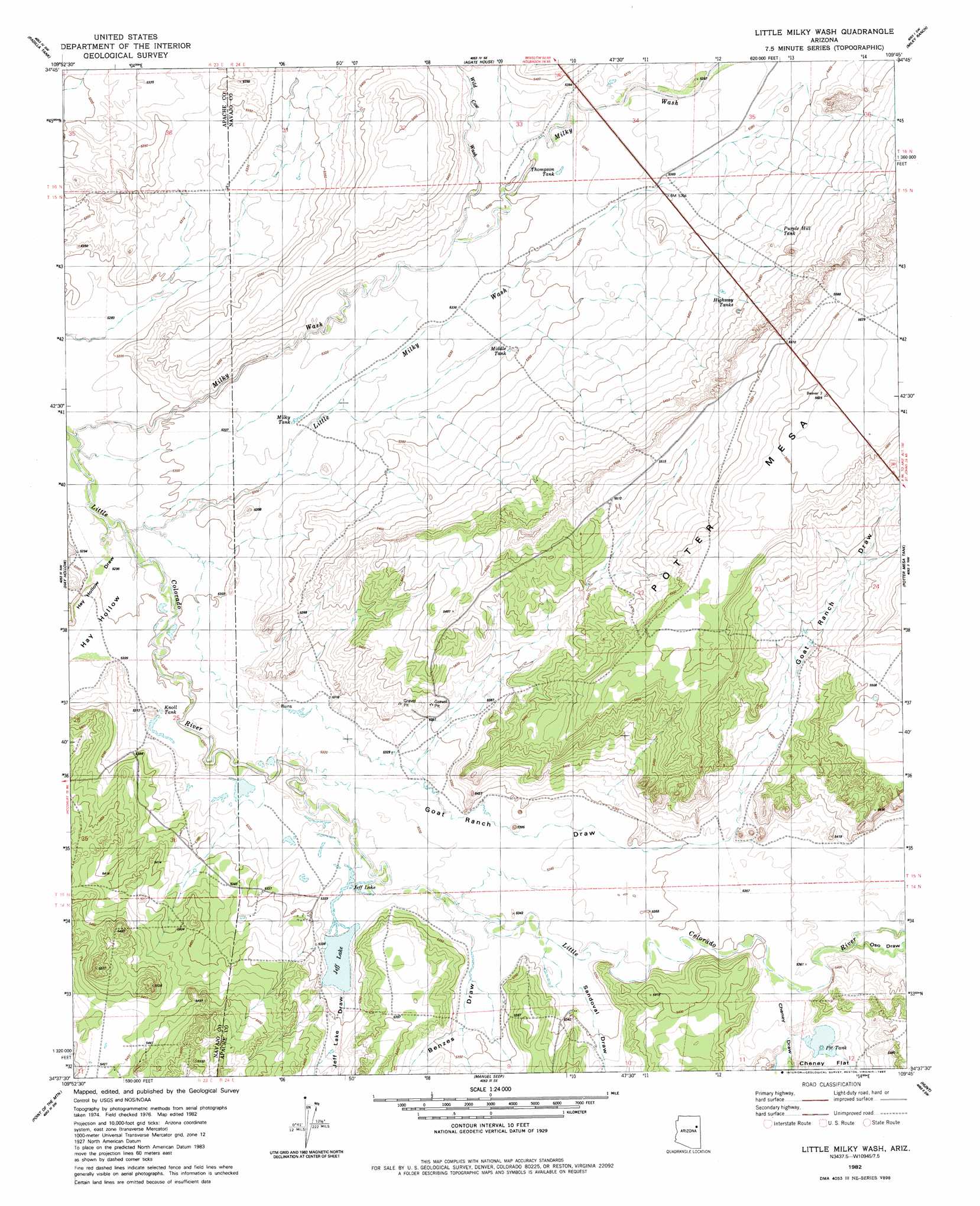
USGS Topo Quad 34109f7 - 1:24,000 scale
| Topo Map Name: | Little Milky Wash |
| USGS Topo Quad ID: | 34109f7 |
| Print Size: | ca. 21 1/4" wide x 27" high |
| Southeast Coordinates: | 34.625° N latitude / 109.75° W longitude |
| Map Center Coordinates: | 34.6875° N latitude / 109.8125° W longitude |
| U.S. State: | AZ |
| Filename: | o34109f7.jpg |
| Download Map JPG Image: | Little Milky Wash topo map 1:24,000 scale |
| Map Type: | Topographic |
| Topo Series: | 7.5´ |
| Map Scale: | 1:24,000 |
| Source of Map Images: | United States Geological Survey (USGS) |
| Alternate Map Versions: |
Adamana 3 NE AZ 1955, updated 1957 Download PDF Buy paper map Little Milky Wash AZ 1982, updated 1983 Download PDF Buy paper map Little Milky Wash AZ 2011 Download PDF Buy paper map Little Milky Wash AZ 2014 Download PDF Buy paper map |
1:24,000 Topo Quads surrounding Little Milky Wash
Sun Valley |
Carrizo Butte |
Adamana |
Sorrel Horse Mesa |
Ninemile Seep |
Woodruff |
Padilla Tank |
Agate House |
Milky Ranch |
Seven Springs |
Tenmile Cedars |
Hay Hollow |
Little Milky Wash |
Potter Mesa Tank |
Stinking Springs Mountain |
Snowflake |
Point Of The Mountain |
Manuel Seep |
Hunt |
Stinking Springs |
Taylor |
Mesa Redonda Nw |
Mesa Redonda |
Concho Lake |
Concho |
> Back to 34109e1 at 1:100,000 scale
> Back to 34108a1 at 1:250,000 scale
> Back to U.S. Topo Maps home
Little Milky Wash topo map: Gazetteer
Little Milky Wash: Flats
Cheney Flat elevation 1635m 5364′Little Milky Wash: Reservoirs
Highway Tanks elevation 1653m 5423′Jeff Lake elevation 1624m 5328′
Knoll Tank elevation 1623m 5324′
Middle Tank elevation 1628m 5341′
Milky Tank elevation 1620m 5314′
Pit Tank elevation 1637m 5370′
Purple Hill Tank elevation 1657m 5436′
Thompson Tank elevation 1633m 5357′
Little Milky Wash: Streams
Little Milky Wash elevation 1618m 5308′Milky Wash elevation 1610m 5282′
Wild Cow Wash elevation 1627m 5337′
Little Milky Wash: Valleys
Benzes Draw elevation 1626m 5334′Cheney Draw elevation 1633m 5357′
Goat Ranch Draw elevation 1621m 5318′
Hay Hollow elevation 1610m 5282′
Hay Hollow Draw elevation 1610m 5282′
Jeff Lake Draw elevation 1624m 5328′
Oso Draw elevation 1635m 5364′
Sandoval Draw elevation 1626m 5334′
West Hay Hollow Draw elevation 1616m 5301′
Little Milky Wash digital topo map on disk
Buy this Little Milky Wash topo map showing relief, roads, GPS coordinates and other geographical features, as a high-resolution digital map file on DVD: