Young Topo Map Arizona
To zoom in, hover over the map of Young
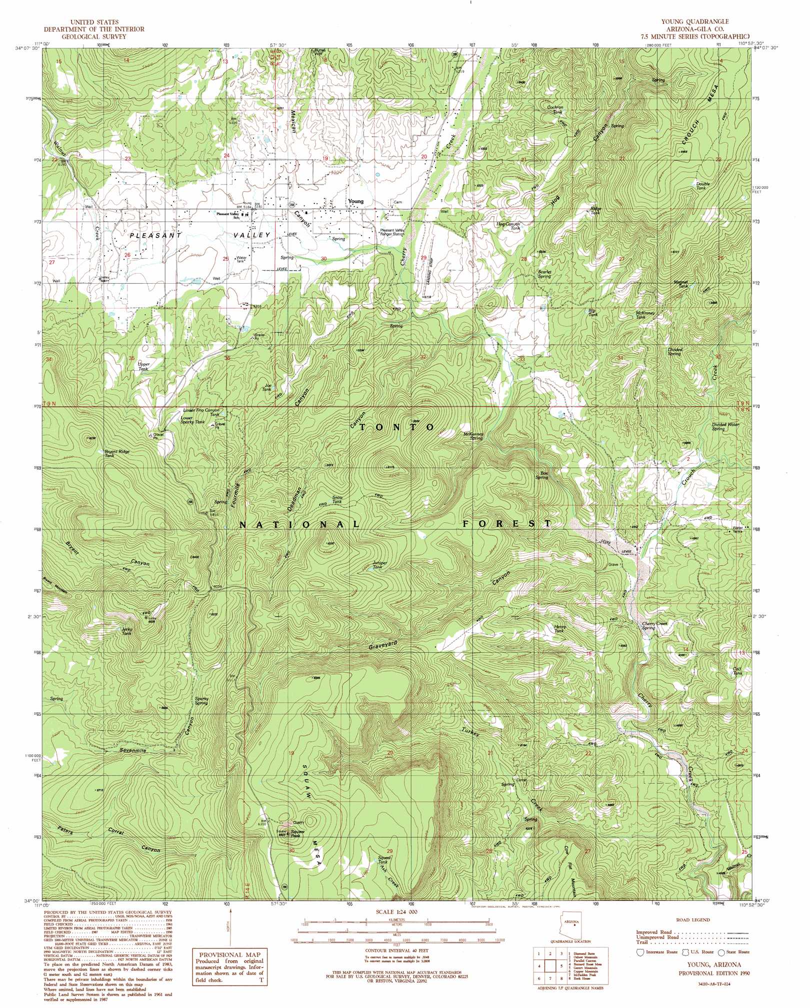
USGS Topo Quad 34110a8 - 1:24,000 scale
| Topo Map Name: | Young |
| USGS Topo Quad ID: | 34110a8 |
| Print Size: | ca. 21 1/4" wide x 27" high |
| Southeast Coordinates: | 34° N latitude / 110.875° W longitude |
| Map Center Coordinates: | 34.0625° N latitude / 110.9375° W longitude |
| U.S. State: | AZ |
| Filename: | o34110a8.jpg |
| Download Map JPG Image: | Young topo map 1:24,000 scale |
| Map Type: | Topographic |
| Topo Series: | 7.5´ |
| Map Scale: | 1:24,000 |
| Source of Map Images: | United States Geological Survey (USGS) |
| Alternate Map Versions: |
Young AZ 1990, updated 1991 Download PDF Buy paper map Young AZ 1990, updated 1991 Download PDF Buy paper map Young AZ 2004, updated 2006 Download PDF Buy paper map Young AZ 2011 Download PDF Buy paper map Young AZ 2014 Download PDF Buy paper map |
| FStopo: | US Forest Service topo Young is available: Download FStopo PDF Download FStopo TIF |
1:24,000 Topo Quads surrounding Young
Diamond Point |
Promontory Butte |
Woods Canyon |
O W Point |
Brookbank Point |
Mcdonald Mountain |
Diamond Butte |
Oxbow Mountain |
Parallel Canyon |
Chediski Peak |
Sheep Basin Mountain |
Buzzard Roost Mesa |
Young |
Gentry Mountain |
Oak Creek Ranch |
Picture Mountain |
Copper Mountain |
Mcfadden Peak |
Rock House |
Double Buttes |
Greenback Creek |
Armer Mountain |
Aztec Peak |
Sombrero Peak |
Picacho Colorado |
> Back to 34110a1 at 1:100,000 scale
> Back to 34110a1 at 1:250,000 scale
> Back to U.S. Topo Maps home
Young topo map: Gazetteer
Young: Forests
Pleasant Valley Ranger District elevation 1841m 6040′Young: Populated Places
Young elevation 1581m 5187′Young: Reservoirs
Big Tank elevation 1573m 5160′Bryant Ridge Tank elevation 1832m 6010′
Byrant Ridge Tank elevation 1834m 6017′
Calf Tank elevation 1567m 5141′
Cherry Creek Tank elevation 1539m 5049′
Cochran Tank elevation 1659m 5442′
Double Tank elevation 1910m 6266′
Henry Tank elevation 1636m 5367′
Hog Canyon Tank elevation 1588m 5209′
Jerky Tank elevation 1812m 5944′
Joe Tank elevation 1634m 5360′
Juniper Tank elevation 1769m 5803′
Lower Frio Canyon Tank elevation 1646m 5400′
Lower Sparky Tank elevation 1658m 5439′
Magnet Tank elevation 1668m 5472′
McKinney Tank elevation 1614m 5295′
Mexican Tank elevation 1609m 5278′
Natural Tank elevation 1486m 4875′
Ridge Tank elevation 1685m 5528′
Snow Tank elevation 1699m 5574′
Snow Tank elevation 1670m 5479′
Squaw Tank elevation 1833m 6013′
Upper Frio Canyon Tank elevation 1659m 5442′
Upper Tank elevation 1633m 5357′
Vosburg Trick Tank elevation 1533m 5029′
Young: Springs
Box Spring elevation 1551m 5088′Cherry Creek Spring elevation 1436m 4711′
Creek Spring elevation 1449m 4753′
Divided Spring elevation 1571m 5154′
Divided Water Spring elevation 1511m 4957′
McKenney Spring elevation 1488m 4881′
Scarlet Spring elevation 1548m 5078′
Sparky Spring elevation 1742m 5715′
Tunnel Spring elevation 1442m 4730′
Young: Streams
Crouch Creek elevation 1445m 4740′Turkey Creek elevation 1390m 4560′
Walnut Creek elevation 1379m 4524′
Young: Summits
Crouch Mesa elevation 1952m 6404′Squaw Mesa elevation 2002m 6568′
Squaw Peak elevation 1988m 6522′
Young: Valleys
Deadman Canyon elevation 1536m 5039′Fourmile Canyon elevation 1540m 5052′
Graveyard Canyon elevation 1458m 4783′
Hog Canyon elevation 1570m 5150′
Mexican Canyon elevation 1585m 5200′
Pleasant Valley elevation 1539m 5049′
Young: Wells
Buttes Well elevation 1629m 5344′Gruwell Well elevation 1629m 5344′
Young digital topo map on disk
Buy this Young topo map showing relief, roads, GPS coordinates and other geographical features, as a high-resolution digital map file on DVD: