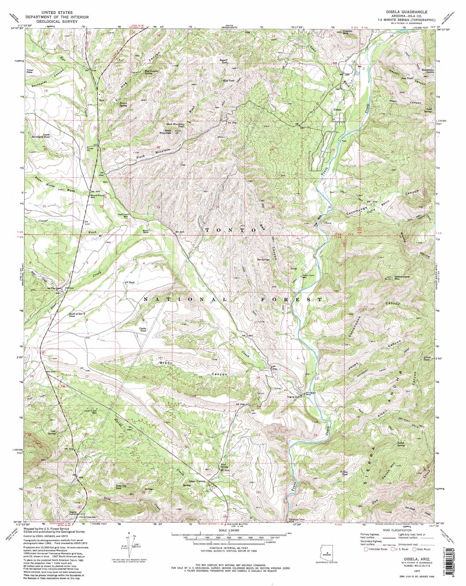
Gisela Topo Map Arizona
To zoom in, hover over the map of Gisela
USGS Topo Quad 34111a3 - 1:24,000 scale
| Topo Map Name: | Gisela |
| USGS Topo Quad ID: | 34111a3 |
| Print Size: | ca. 21 1/4" wide x 27" high |
| Southeast Coordinates: | 34° N latitude / 111.25° W longitude |
| Map Center Coordinates: | 34.0625° N latitude / 111.3125° W longitude |
| U.S. State: | AZ |
| Filename: | o34111a3.jpg |
| Download Map JPG Image: | Gisela topo map 1:24,000 scale |
| Map Type: | Topographic |
| Topo Series: | 7.5´ |
| Map Scale: | 1:24,000 |
| Source of Map Images: | United States Geological Survey (USGS) |
| Alternate Map Versions: |
Gisela AZ 1972, updated 1974 Download PDF Buy paper map Gisela AZ 1972, updated 1982 Download PDF Buy paper map Gisela AZ 1972, updated 1982 Download PDF Buy paper map Gisela AZ 2004, updated 2006 Download PDF Buy paper map Gisela AZ 2011 Download PDF Buy paper map Gisela AZ 2014 Download PDF Buy paper map |
| FStopo: | US Forest Service topo Gisela is available: Download FStopo PDF Download FStopo TIF |
1:24,000 Topo Quads surrounding Gisela
Cane Springs Mountain |
Buckhead Mesa |
Payson North |
Diamond Point |
Promontory Butte |
Cypress Butte |
North Peak |
Payson South |
Mcdonald Mountain |
Diamond Butte |
Table Mountain |
Mazatzal Peak |
Gisela |
Sheep Basin Mountain |
Buzzard Roost Mesa |
Lion Mountain |
Reno Pass |
Kayler Butte |
Picture Mountain |
Copper Mountain |
Maverick Mountain |
Boulder Mountain |
Tonto Basin |
Greenback Creek |
Armer Mountain |
> Back to 34111a1 at 1:100,000 scale
> Back to 34110a1 at 1:250,000 scale
> Back to U.S. Topo Maps home
Gisela topo map: Gazetteer
Gisela: Basins
Curry Basin elevation 941m 3087′Gisela: Gaps
Breakdown Saddle elevation 1168m 3832′Gisela: Mines
Pittsburg Tonto Mine elevation 803m 2634′Gisela: Populated Places
Deer Creek Village Subdivision elevation 942m 3090′Gisela elevation 878m 2880′
Jakes Corner elevation 854m 2801′
Rye elevation 955m 3133′
Gisela: Reservoirs
Alkali Tank elevation 1158m 3799′Bassett Tank elevation 1179m 3868′
Black Mountain Tank elevation 1064m 3490′
Coulee Tank elevation 992m 3254′
Gisela Tank elevation 1287m 4222′
Hale Tank elevation 1145m 3756′
Lower Barnhardt Tank elevation 1000m 3280′
South of Bar T Tank elevation 980m 3215′
Table Top Tank elevation 1071m 3513′
Three V Tank elevation 952m 3123′
Tom Tank elevation 1054m 3458′
Willow Tank elevation 1007m 3303′
Gisela: Springs
Alkali Spring elevation 1031m 3382′Bee Spring elevation 951m 3120′
Brown Spring elevation 986m 3234′
Felton Spring elevation 1090m 3576′
Hog Canyon Spring elevation 1021m 3349′
Mud Spring elevation 865m 2837′
Neal Spring elevation 1186m 3891′
Oak Spring elevation 1034m 3392′
Sand Wash Spring elevation 975m 3198′
Sycamore Spring elevation 975m 3198′
Gisela: Streams
Bear Creek elevation 949m 3113′Black Mountain Wash elevation 936m 3070′
Boone Moore Wash elevation 925m 3034′
Clover Wash elevation 914m 2998′
Deer Creek elevation 897m 2942′
Del Shay Creek elevation 983m 3225′
Rye Creek elevation 822m 2696′
Sand Wash elevation 878m 2880′
Sycamore Wash elevation 974m 3195′
Gisela: Summits
Black Mountain elevation 1208m 3963′Cottonwood Mountain elevation 1367m 4484′
Felton Mountain elevation 1281m 4202′
Haycox Mountain elevation 1112m 3648′
Gisela: Valleys
Alkali Canyon elevation 839m 2752′Barnhardt Canyon elevation 976m 3202′
Bee Canyon elevation 851m 2791′
Brady Canyon elevation 852m 2795′
Brushy Hollow elevation 922m 3024′
Cocomunga Canyon elevation 865m 2837′
Cottonwood Canyon elevation 840m 2755′
Grass Valley (historical) elevation 878m 2880′
Haycox Canyon elevation 890m 2919′
Hog Canyon elevation 959m 3146′
Jones Canyon elevation 847m 2778′
Midget Draw elevation 987m 3238′
Neal Canyon elevation 888m 2913′
Oxbow Gulch elevation 987m 3238′
The Box elevation 859m 2818′
Gisela: Wells
Boone Moore Well elevation 927m 3041′Gold Creek Well elevation 1062m 3484′
Hardt Creek Well elevation 932m 3057′
Indian Farm Well elevation 868m 2847′
Rye Creek Well elevation 902m 2959′
Gisela digital topo map on disk
Buy this Gisela topo map showing relief, roads, GPS coordinates and other geographical features, as a high-resolution digital map file on DVD: