Mcdonald Mountain Topo Map Arizona
To zoom in, hover over the map of Mcdonald Mountain
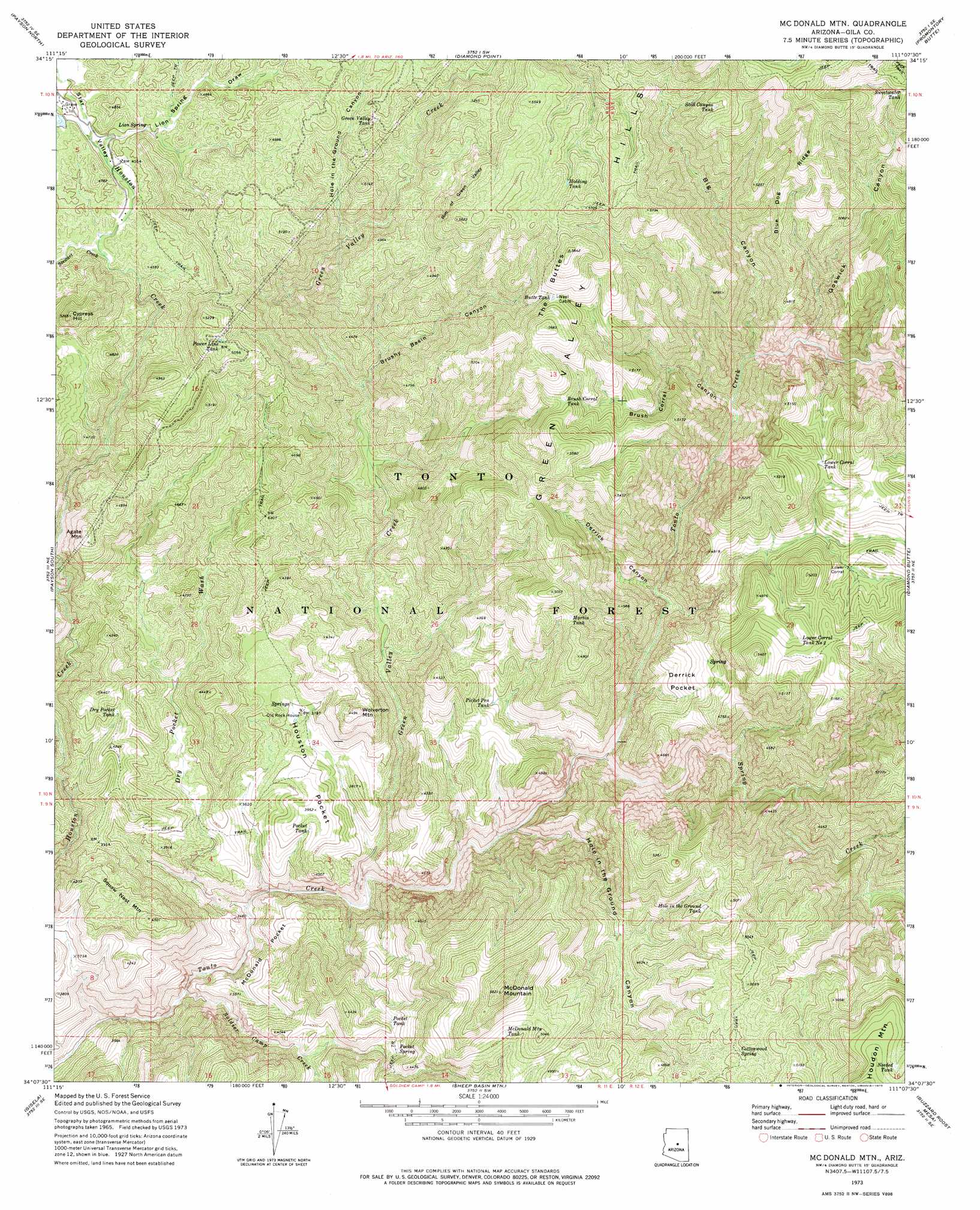
USGS Topo Quad 34111b2 - 1:24,000 scale
| Topo Map Name: | Mcdonald Mountain |
| USGS Topo Quad ID: | 34111b2 |
| Print Size: | ca. 21 1/4" wide x 27" high |
| Southeast Coordinates: | 34.125° N latitude / 111.125° W longitude |
| Map Center Coordinates: | 34.1875° N latitude / 111.1875° W longitude |
| U.S. State: | AZ |
| Filename: | o34111b2.jpg |
| Download Map JPG Image: | Mcdonald Mountain topo map 1:24,000 scale |
| Map Type: | Topographic |
| Topo Series: | 7.5´ |
| Map Scale: | 1:24,000 |
| Source of Map Images: | United States Geological Survey (USGS) |
| Alternate Map Versions: |
McDonald Mtn AZ 1973, updated 1975 Download PDF Buy paper map McDonald Mountain AZ 2004, updated 2007 Download PDF Buy paper map McDonald Mountain AZ 2011 Download PDF Buy paper map McDonald Mountain AZ 2014 Download PDF Buy paper map |
| FStopo: | US Forest Service topo McDonald Mountain is available: Download FStopo PDF Download FStopo TIF |
1:24,000 Topo Quads surrounding Mcdonald Mountain
Pine |
Kehl Ridge |
Dane Canyon |
Knoll Lake |
Porcupine Ridge |
Buckhead Mesa |
Payson North |
Diamond Point |
Promontory Butte |
Woods Canyon |
North Peak |
Payson South |
Mcdonald Mountain |
Diamond Butte |
Oxbow Mountain |
Mazatzal Peak |
Gisela |
Sheep Basin Mountain |
Buzzard Roost Mesa |
Young |
Reno Pass |
Kayler Butte |
Picture Mountain |
Copper Mountain |
Mcfadden Peak |
> Back to 34111a1 at 1:100,000 scale
> Back to 34110a1 at 1:250,000 scale
> Back to U.S. Topo Maps home
Mcdonald Mountain topo map: Gazetteer
Mcdonald Mountain: Basins
Derrick Pocket elevation 1272m 4173′Houston Pocket elevation 1177m 3861′
McDonald Pocket elevation 1082m 3549′
Mcdonald Mountain: Dams
Number One Dam elevation 1443m 4734′Mcdonald Mountain: Ranges
Green Valley Hills elevation 1636m 5367′Mcdonald Mountain: Reservoirs
Brush Corral Tank elevation 1570m 5150′Butte Tank elevation 1620m 5314′
Dry Pocket Tank elevation 1261m 4137′
Green Valley Tank elevation 1499m 4917′
Holding Tank elevation 1647m 5403′
Hole in the Ground Tank elevation 1463m 4799′
Lower Corral Tank elevation 1464m 4803′
Lower Corral Tank Number Two elevation 1510m 4954′
Martin Tank elevation 1437m 4714′
McDonald Mountain Tank elevation 1470m 4822′
Needed Tank elevation 1690m 5544′
Picket Pen Tank elevation 1219m 3999′
Pocket Tank elevation 1168m 3832′
Pocket Tank elevation 1243m 4078′
Power Line Tank elevation 1536m 5039′
Still Canyon Tank elevation 1632m 5354′
Sweetwater Tank elevation 1668m 5472′
Mcdonald Mountain: Ridges
Blue Dog Ridge elevation 1560m 5118′Rim of Green Valley elevation 1622m 5321′
Mcdonald Mountain: Springs
Cottonwood Spring elevation 1453m 4767′Lion Spring elevation 1401m 4596′
Pocket Spring elevation 1258m 4127′
Mcdonald Mountain: Streams
Dry Pocket Wash elevation 965m 3166′Green Valley Creek elevation 986m 3234′
Soldier Camp Creek elevation 961m 3152′
Spring Creek elevation 1041m 3415′
Stewart Creek elevation 1364m 4475′
Mcdonald Mountain: Summits
Agate Mountain elevation 1491m 4891′Cypress Hill elevation 1601m 5252′
McDonald Mountain elevation 1709m 5606′
Squaw Nest Mountain elevation 1370m 4494′
The Buttes elevation 1781m 5843′
Wolverton Mountain elevation 1353m 4438′
Mcdonald Mountain: Valleys
Big Canyon elevation 1124m 3687′Brush Corral Canyon elevation 1122m 3681′
Brushy Basin Canyon elevation 1186m 3891′
Derrick Canyon elevation 1080m 3543′
Goswick Canyon elevation 1152m 3779′
Hole in the Ground Canyon elevation 1016m 3333′
Hole in the Ground Canyon elevation 1339m 4393′
Lion Spring Draw elevation 1383m 4537′
Star Valley elevation 1383m 4537′
Mcdonald Mountain digital topo map on disk
Buy this Mcdonald Mountain topo map showing relief, roads, GPS coordinates and other geographical features, as a high-resolution digital map file on DVD: