Knoll Lake Topo Map Arizona
To zoom in, hover over the map of Knoll Lake
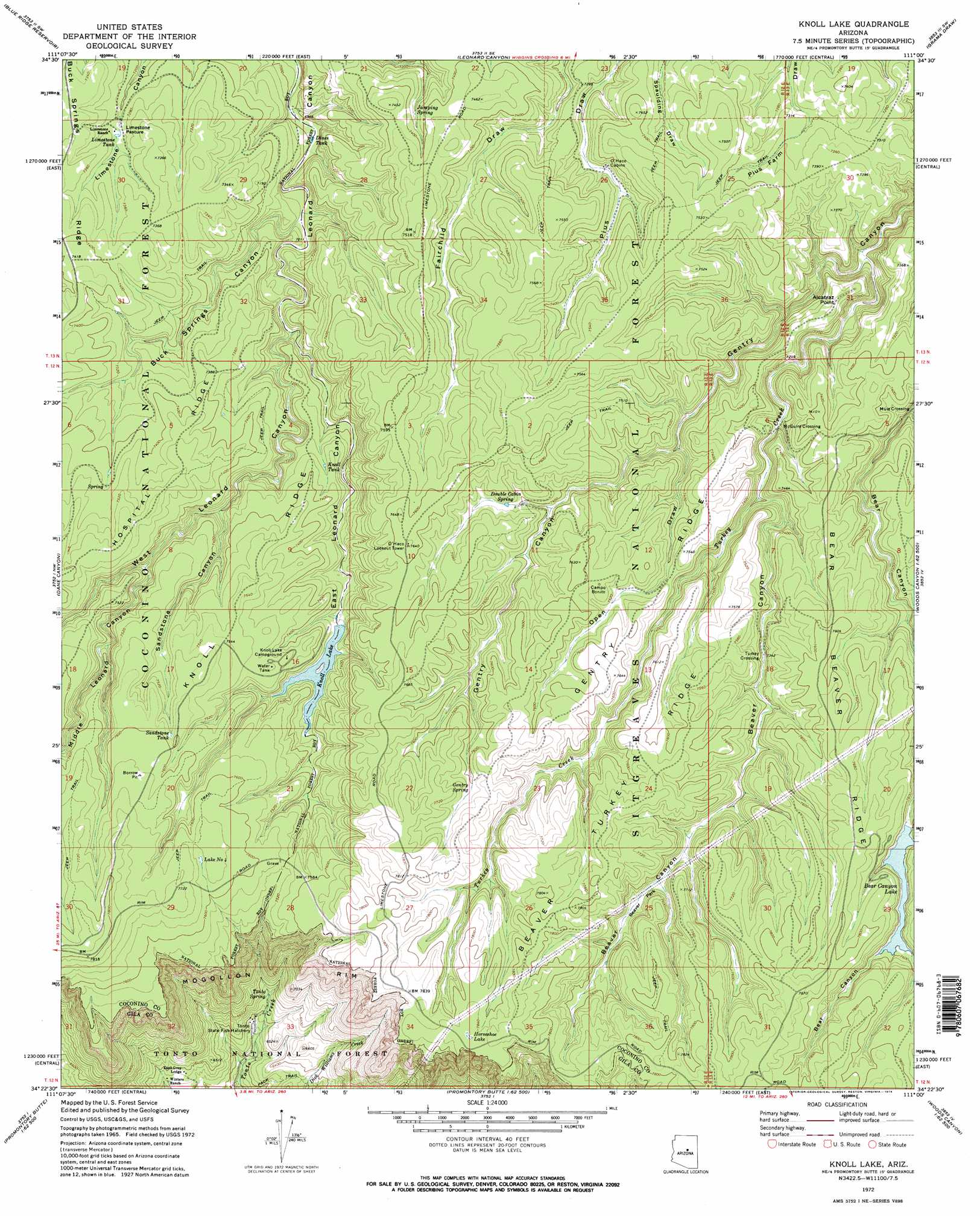
USGS Topo Quad 34111d1 - 1:24,000 scale
| Topo Map Name: | Knoll Lake |
| USGS Topo Quad ID: | 34111d1 |
| Print Size: | ca. 21 1/4" wide x 27" high |
| Southeast Coordinates: | 34.375° N latitude / 111° W longitude |
| Map Center Coordinates: | 34.4375° N latitude / 111.0625° W longitude |
| U.S. State: | AZ |
| Filename: | o34111d1.jpg |
| Download Map JPG Image: | Knoll Lake topo map 1:24,000 scale |
| Map Type: | Topographic |
| Topo Series: | 7.5´ |
| Map Scale: | 1:24,000 |
| Source of Map Images: | United States Geological Survey (USGS) |
| Alternate Map Versions: |
Knoll Lake AZ 1972, updated 1974 Download PDF Buy paper map Knoll Lake AZ 1972, updated 1974 Download PDF Buy paper map Knoll Lake AZ 1998, updated 2000 Download PDF Buy paper map Knoll Lake AZ 2004, updated 2006 Download PDF Buy paper map Knoll Lake AZ 2011 Download PDF Buy paper map Knoll Lake AZ 2014 Download PDF Buy paper map |
| FStopo: | US Forest Service topo Knoll Lake is available: Download FStopo PDF Download FStopo TIF |
1:24,000 Topo Quads surrounding Knoll Lake
Turkey Mountain |
Hay Lake |
Quayle Hill |
Hamilton Crossing |
Chevelon Butte |
Long Valley |
Blue Ridge Reservoir |
Leonard Canyon |
Grama Draw |
Chevelon Crossing |
Kehl Ridge |
Dane Canyon |
Knoll Lake |
Porcupine Ridge |
Weimer Point |
Payson North |
Diamond Point |
Promontory Butte |
Woods Canyon |
O W Point |
Payson South |
Mcdonald Mountain |
Diamond Butte |
Oxbow Mountain |
Parallel Canyon |
> Back to 34111a1 at 1:100,000 scale
> Back to 34110a1 at 1:250,000 scale
> Back to U.S. Topo Maps home
Knoll Lake topo map: Gazetteer
Knoll Lake: Cliffs
Alcatraz Point elevation 2245m 7365′Knoll Lake: Crossings
McGuire Crossing elevation 2180m 7152′Knoll Lake: Dams
Bear Canyon Dam elevation 2298m 7539′Knoll Dam elevation 2228m 7309′
Knoll Lake: Flats
Beaver Park elevation 2276m 7467′Limestone Pasture elevation 2248m 7375′
Knoll Lake: Lakes
Horseshoe Lake elevation 2411m 7910′Lake Number Four elevation 2329m 7641′
Knoll Lake: Parks
Bear Canyon Lake Recreation Area elevation 2338m 7670′Knoll Lake: Populated Places
Campo Bonito elevation 2308m 7572′Mule Crossing elevation 2175m 7135′
Turkey Crossing elevation 2242m 7355′
Knoll Lake: Reservoirs
Bear Canyon Lake elevation 2298m 7539′Bench Tank elevation 2267m 7437′
Dines Tank elevation 2131m 6991′
Jake Tank elevation 2262m 7421′
Jones Tank elevation 2232m 7322′
Knoll Lake elevation 2228m 7309′
Knoll Tank elevation 2230m 7316′
Lake Number Four elevation 2329m 7641′
Limestone Tank elevation 2215m 7267′
Rim Tank elevation 2324m 7624′
Sandstone Tank elevation 2307m 7568′
Tonto Tank elevation 2297m 7536′
Turkey Tank elevation 2352m 7716′
Turkey Tree Tank elevation 2347m 7700′
Knoll Lake: Ridges
Bear Beaver Ridge elevation 2328m 7637′Beaver Turkey Ridge elevation 2356m 7729′
Gentry Ridge elevation 2278m 7473′
Knoll Ridge elevation 2303m 7555′
Rattlesnake Ridge elevation 2359m 7739′
Knoll Lake: Springs
Double Cabin Spring elevation 2263m 7424′Gentry Spring elevation 2323m 7621′
Jumping Spring elevation 2227m 7306′
Section Thirty-three Spring elevation 2196m 7204′
Tonto Spring elevation 1982m 6502′
Whiskey Springs elevation 2244m 7362′
Knoll Lake: Streams
East Leonard Canyon Creek elevation 2331m 7647′Turkey Creek elevation 2129m 6984′
Knoll Lake: Valleys
Bear Canyon elevation 2188m 7178′Beaver Canyon elevation 2196m 7204′
Buck Springs Canyon elevation 2143m 7030′
East Leonard Canyon elevation 2155m 7070′
Middle Leonard Canyon elevation 2216m 7270′
Open Draw elevation 2207m 7240′
Sandstone Canyon elevation 2204m 7230′
West Leonard Canyon elevation 2161m 7089′
Knoll Lake digital topo map on disk
Buy this Knoll Lake topo map showing relief, roads, GPS coordinates and other geographical features, as a high-resolution digital map file on DVD: