Pine Topo Map Arizona
To zoom in, hover over the map of Pine
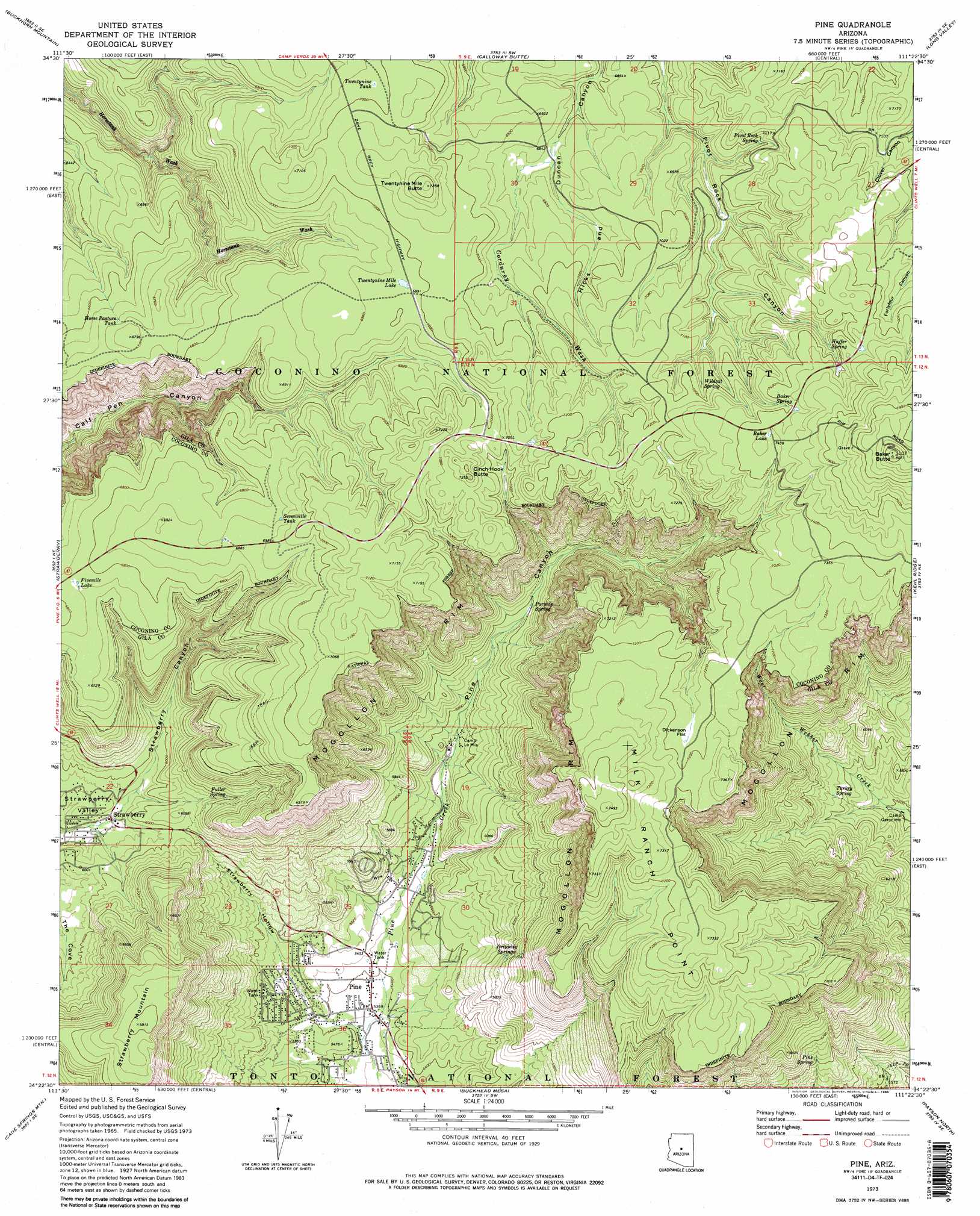
USGS Topo Quad 34111d4 - 1:24,000 scale
| Topo Map Name: | Pine |
| USGS Topo Quad ID: | 34111d4 |
| Print Size: | ca. 21 1/4" wide x 27" high |
| Southeast Coordinates: | 34.375° N latitude / 111.375° W longitude |
| Map Center Coordinates: | 34.4375° N latitude / 111.4375° W longitude |
| U.S. State: | AZ |
| Filename: | o34111d4.jpg |
| Download Map JPG Image: | Pine topo map 1:24,000 scale |
| Map Type: | Topographic |
| Topo Series: | 7.5´ |
| Map Scale: | 1:24,000 |
| Source of Map Images: | United States Geological Survey (USGS) |
| Alternate Map Versions: |
Pine AZ 1973, updated 1975 Download PDF Buy paper map Pine AZ 1973, updated 1985 Download PDF Buy paper map Pine AZ 1973, updated 1985 Download PDF Buy paper map Pine AZ 2011 Download PDF Buy paper map Pine AZ 2014 Download PDF Buy paper map |
| FStopo: | US Forest Service topo Pine is available: Download FStopo PDF Download FStopo TIF |
1:24,000 Topo Quads surrounding Pine
Casner Butte |
Apache Maid Mountain |
Happy Jack |
Turkey Mountain |
Hay Lake |
Walker Mountain |
Buckhorn Mountain |
Calloway Butte |
Long Valley |
Blue Ridge Reservoir |
Hackberry Mountain |
Strawberry |
Pine |
Kehl Ridge |
Dane Canyon |
Verde Hot Springs |
Cane Springs Mountain |
Buckhead Mesa |
Payson North |
Diamond Point |
Wet Bottom Mesa |
Cypress Butte |
North Peak |
Payson South |
Mcdonald Mountain |
> Back to 34111a1 at 1:100,000 scale
> Back to 34110a1 at 1:250,000 scale
> Back to U.S. Topo Maps home
Pine topo map: Gazetteer
Pine: Basins
Strawberry Valley elevation 1787m 5862′Pine: Cliffs
Milk Ranch Point elevation 2184m 7165′Pine: Flats
Dickenson Flat elevation 2192m 7191′Pine: Lakes
Baker Lake elevation 2269m 7444′Fivemile Lake elevation 2062m 6765′
Twentynine Mile Lake elevation 2131m 6991′
Pine: Populated Places
Pine elevation 1636m 5367′Strawberry elevation 1795m 5889′
Pine: Post Offices
Pine Post Office elevation 1643m 5390′Pine: Reservoirs
Corner Tank elevation 2083m 6833′Dickenson Flat Tank elevation 2194m 7198′
Garden Tank elevation 2135m 7004′
Hicks and Duncan Tank elevation 2104m 6902′
Horse Pasture Tank elevation 2040m 6692′
Sevenmile Tank elevation 2096m 6876′
Twentynine Tank elevation 2130m 6988′
Pine: Springs
Baker Spring elevation 2232m 7322′Cottonwood Spring elevation 1751m 5744′
Dripping Springs elevation 1846m 6056′
Fuller Spring elevation 1888m 6194′
Huffer Springs elevation 2229m 7312′
Parsnip Spring elevation 1830m 6003′
Pine Spring elevation 1834m 6017′
Pivot Rock Spring elevation 2143m 7030′
Turkey Spring elevation 1783m 5849′
Wildcat Spring elevation 2178m 7145′
Pine: Streams
Corduroy Wash elevation 2085m 6840′Pine: Summits
Baker Butte elevation 2456m 8057′Cinch Hook Butte elevation 2210m 7250′
Strawberry Mountain elevation 2074m 6804′
Twentynine Mile Butte elevation 2210m 7250′
Pine: Valleys
Pine Canyon elevation 1647m 5403′Strawberry Canyon elevation 1805m 5921′
Strawberry Hollow elevation 1633m 5357′
Pine digital topo map on disk
Buy this Pine topo map showing relief, roads, GPS coordinates and other geographical features, as a high-resolution digital map file on DVD: