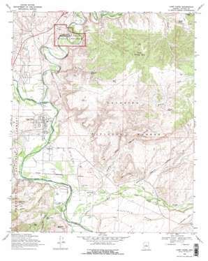
Camp Verde Topo Map Arizona
To zoom in, hover over the map of Camp Verde
USGS Topo Quad 34111e7 - 1:24,000 scale
| Topo Map Name: | Camp Verde |
| USGS Topo Quad ID: | 34111e7 |
| Print Size: | ca. 21 1/4" wide x 27" high |
| Southeast Coordinates: | 34.5° N latitude / 111.75° W longitude |
| Map Center Coordinates: | 34.5625° N latitude / 111.8125° W longitude |
| U.S. State: | AZ |
| Filename: | o34111e7.jpg |
| Download Map JPG Image: | Camp Verde topo map 1:24,000 scale |
| Map Type: | Topographic |
| Topo Series: | 7.5´ |
| Map Scale: | 1:24,000 |
| Source of Map Images: | United States Geological Survey (USGS) |
| Alternate Map Versions: |
Camp Verde AZ 1969, updated 1971 Download PDF Buy paper map Camp Verde AZ 1969, updated 1971 Download PDF Buy paper map Camp Verde AZ 2012 Download PDF Buy paper map Camp Verde AZ 2014 Download PDF Buy paper map |
| FStopo: | US Forest Service topo Camp Verde is available: Download FStopo PDF Download FStopo TIF |
1:24,000 Topo Quads surrounding Camp Verde
> Back to 34111e1 at 1:100,000 scale
> Back to 34110a1 at 1:250,000 scale
> Back to U.S. Topo Maps home
Camp Verde topo map: Gazetteer
Camp Verde: Airports
Camp Verde Airport elevation 948m 3110′Montezuma Airport elevation 1029m 3375′
Camp Verde: Canals
Woods Ditch elevation 941m 3087′Camp Verde: Populated Places
Camp Verde elevation 961m 3152′Clear Creek elevation 939m 3080′
Country Estates elevation 932m 3057′
Fort River Caves elevation 940m 3083′
Fort Verde Estates elevation 935m 3067′
Jordan Meadows elevation 928m 3044′
Mesa Verde Estates elevation 953m 3126′
Mountain View Estates elevation 938m 3077′
Paradise Acres elevation 932m 3057′
Pioneer Acres elevation 945m 3100′
Reddells Ranch Acres elevation 944m 3097′
Security Acres elevation 941m 3087′
Tres Rios elevation 938m 3077′
Verde River Meadows One elevation 943m 3093′
Wingfield elevation 956m 3136′
Camp Verde: Post Offices
Camp Verde Post Office elevation 955m 3133′Camp Verde: Reservoirs
Bills Tank elevation 1119m 3671′Cochran Tank elevation 972m 3188′
Cochran Tank elevation 978m 3208′
Deep Tank elevation 1026m 3366′
Goswick Tank elevation 1146m 3759′
Hat Ranch Tank elevation 963m 3159′
Limestone Tank elevation 1053m 3454′
Monkey Tank elevation 1150m 3772′
Monroe Tank elevation 936m 3070′
Ralston Tank elevation 1081m 3546′
Schroeder Tank elevation 1143m 3750′
Squaw Peak Tank elevation 978m 3208′
Stewards Tank elevation 1084m 3556′
Test Hole Tank elevation 1176m 3858′
Vee Seven Tank elevation 952m 3123′
White Hill Tank elevation 976m 3202′
Wikiup Tank elevation 1149m 3769′
Young Tank elevation 932m 3057′
Camp Verde: Springs
Cottonwood Spring elevation 1082m 3549′Russell Spring elevation 1084m 3556′
Camp Verde: Streams
Beaver Creek elevation 937m 3074′West Clear Creek elevation 915m 3001′
Wickiup Creek elevation 933m 3061′
Camp Verde: Summits
Middle Schroeder Butte elevation 1208m 3963′Russell Hill elevation 1207m 3959′
Wikiup Mesa elevation 1189m 3900′
Camp Verde: Valleys
Allen Canyon elevation 945m 3100′Copper Canyon elevation 931m 3054′
Lucky Canyon elevation 932m 3057′
Ryal Canyon elevation 932m 3057′
Squaw Peak Canyon elevation 921m 3021′
West Clear Creek Canyon elevation 915m 3001′
Camp Verde digital topo map on disk
Buy this Camp Verde topo map showing relief, roads, GPS coordinates and other geographical features, as a high-resolution digital map file on DVD:


