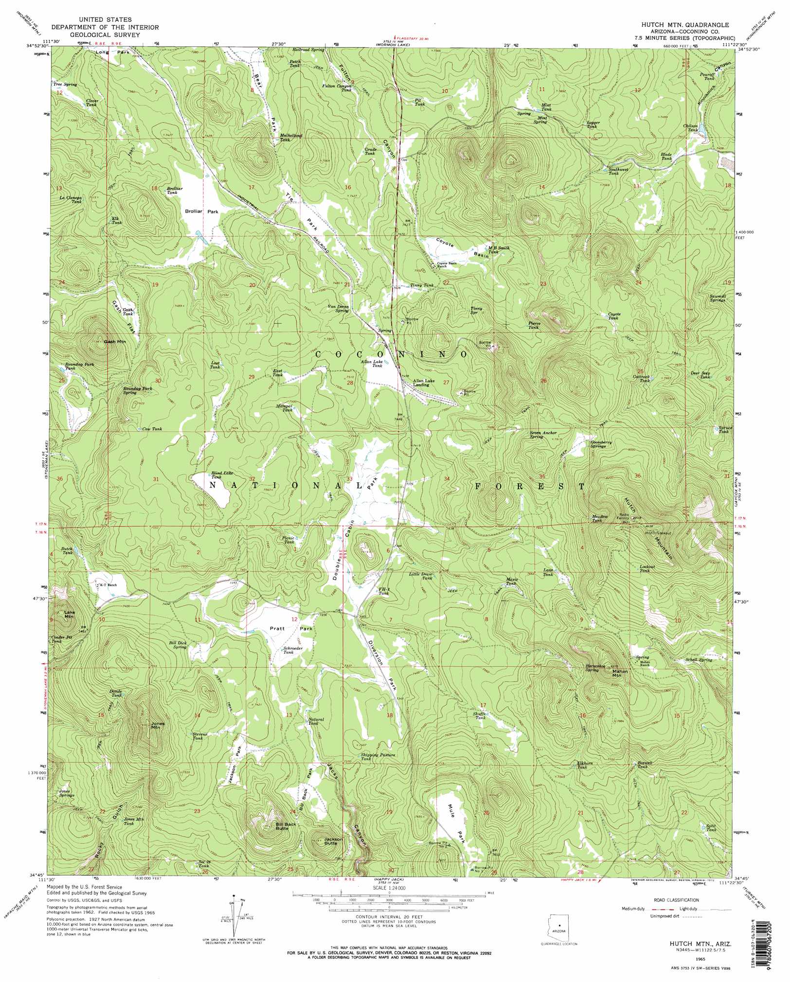
Hutch Mountain Topo Map Arizona
To zoom in, hover over the map of Hutch Mountain
USGS Topo Quad 34111g4 - 1:24,000 scale
| Topo Map Name: | Hutch Mountain |
| USGS Topo Quad ID: | 34111g4 |
| Print Size: | ca. 21 1/4" wide x 27" high |
| Southeast Coordinates: | 34.75° N latitude / 111.375° W longitude |
| Map Center Coordinates: | 34.8125° N latitude / 111.4375° W longitude |
| U.S. State: | AZ |
| Filename: | o34111g4.jpg |
| Download Map JPG Image: | Hutch Mountain topo map 1:24,000 scale |
| Map Type: | Topographic |
| Topo Series: | 7.5´ |
| Map Scale: | 1:24,000 |
| Source of Map Images: | United States Geological Survey (USGS) |
| Alternate Map Versions: |
Hutch Mtn. AZ 1965, updated 1967 Download PDF Buy paper map Hutch Mtn. AZ 1965, updated 1972 Download PDF Buy paper map Hutch Mtn. AZ 1965, updated 1972 Download PDF Buy paper map Hutch Mtn. AZ 1965, updated 1972 Download PDF Buy paper map Hutch Mountain AZ 2011 Download PDF Buy paper map Hutch Mountain AZ 2014 Download PDF Buy paper map |
| FStopo: | US Forest Service topo Hutch Mountain is available: Download FStopo PDF Download FStopo TIF |
1:24,000 Topo Quads surrounding Hutch Mountain
Mountainaire |
Lower Lake Mary |
Ashurst Lake |
Elliott Canyon |
Anderson Canyon |
Munds Park |
Mormon Mountain |
Mormon Lake |
Kinnikinick Lake |
Chavez Mountain Nw |
Munds Mountain |
Stoneman Lake |
Hutch Mountain |
Jaycox Mountain |
Chavez Mountain West |
Casner Butte |
Apache Maid Mountain |
Happy Jack |
Turkey Mountain |
Hay Lake |
Walker Mountain |
Buckhorn Mountain |
Calloway Butte |
Long Valley |
Blue Ridge Reservoir |
> Back to 34111e1 at 1:100,000 scale
> Back to 34110a1 at 1:250,000 scale
> Back to U.S. Topo Maps home
Hutch Mountain topo map: Gazetteer
Hutch Mountain: Basins
Coyote Basin elevation 2269m 7444′Hutch Mountain: Flats
Bear Park elevation 2233m 7326′Bill Back Park elevation 2237m 7339′
Brolliar Park elevation 2249m 7378′
Diversion Park elevation 2240m 7349′
Double Cabin Park elevation 2243m 7358′
Gash Flat elevation 2232m 7322′
Jackson Park elevation 2250m 7381′
Mule Park elevation 2308m 7572′
Pratt Park elevation 2241m 7352′
Roundup Park elevation 2213m 7260′
Tie Park elevation 2263m 7424′
Hutch Mountain: Populated Places
Allan Lake Landing elevation 2275m 7463′Coyote Basin Ranch elevation 2266m 7434′
Hutch Mountain: Reservoirs
Allan Lake Tank elevation 2275m 7463′Blade Tank elevation 2262m 7421′
Blind Lake Tank elevation 2317m 7601′
Borrow Pit Number One Tank elevation 2313m 7588′
Borrow Pit Number Two Tank elevation 2311m 7582′
Boswell Tank elevation 2320m 7611′
Brolliar Tank elevation 2252m 7388′
Bull Tank elevation 2289m 7509′
Butch Tank elevation 2227m 7306′
Cattrack Tank elevation 2335m 7660′
Chilson Tank elevation 2256m 7401′
Clover Tank elevation 2213m 7260′
Cow Tank elevation 2305m 7562′
Coyote Tank elevation 2372m 7782′
Deer Seep Tank elevation 2279m 7477′
Divide Tank elevation 2311m 7582′
East Tank elevation 2291m 7516′
Elk Tank elevation 2265m 7431′
Elkhorn Tank elevation 2312m 7585′
FH-three Tank elevation 2244m 7362′
Fulton Canyon elevation 2231m 7319′
Fulton Canyon Tank elevation 2233m 7326′
Gash Tank elevation 2227m 7306′
Grade Tank elevation 2251m 7385′
Howard Tank elevation 2249m 7378′
J Railroad Tank elevation 2230m 7316′
Jones Mountain Tank elevation 2177m 7142′
La Cienega Tank elevation 2267m 7437′
Lane Tank elevation 2334m 7657′
Little Draw Tank elevation 2264m 7427′
Logger Tank elevation 2318m 7604′
Lookout Tank elevation 2484m 8149′
Lost Tank elevation 2301m 7549′
Mahan Tank elevation 2346m 7696′
Mahan Tank elevation 2395m 7857′
Malapai Tank elevation 2284m 7493′
Maxie Tank elevation 2304m 7559′
MB Smith Tank elevation 2280m 7480′
Meadow Tank elevation 2419m 7936′
Mint Tank elevation 2327m 7634′
Mulholland Tank elevation 2251m 7385′
Natural Tank elevation 2232m 7322′
Park Tank elevation 2249m 7378′
Patch Tank elevation 2245m 7365′
Picnic Tank elevation 2266m 7434′
Pierce Tank elevation 2306m 7565′
Pit Tank elevation 2265m 7431′
Pouroff Tank elevation 2237m 7339′
Roundup Park Tank elevation 2205m 7234′
Schroeder Tank elevation 2242m 7355′
Section Twenty-six Tank elevation 2196m 7204′
Shipping Pasture Tank elevation 2249m 7378′
Shuffs Tank elevation 2307m 7568′
Southeast Tank elevation 2291m 7516′
Split Tank elevation 2261m 7417′
Spruce Tank elevation 2296m 7532′
Stevens Tank elevation 2287m 7503′
Tinny Tank elevation 2268m 7440′
Hutch Mountain: Springs
Bill Dick Spring elevation 2269m 7444′Gooseberry Springs elevation 2393m 7851′
Horseshoe Spring elevation 2385m 7824′
Jones Springs elevation 2155m 7070′
Mahan Spring elevation 2353m 7719′
Mint Spring elevation 2326m 7631′
Railroad Spring elevation 2230m 7316′
Roundup Park Spring elevation 2246m 7368′
Sawmill Springs elevation 2243m 7358′
Schell Spring elevation 2359m 7739′
Seven Anchor Spring elevation 2371m 7778′
Tinny Spring elevation 2308m 7572′
Van Deren Spring elevation 2279m 7477′
Hutch Mountain: Summits
Bill Back Butte elevation 2356m 7729′Gash Mountain elevation 2357m 7732′
Hutch Mountain elevation 2598m 8523′
Jackson Butte elevation 2327m 7634′
Jones Mountain elevation 2417m 7929′
Lake Mountain elevation 2390m 7841′
Mahan Mountain elevation 2512m 8241′
Hutch Mountain digital topo map on disk
Buy this Hutch Mountain topo map showing relief, roads, GPS coordinates and other geographical features, as a high-resolution digital map file on DVD: