Page Springs Topo Map Arizona
To zoom in, hover over the map of Page Springs
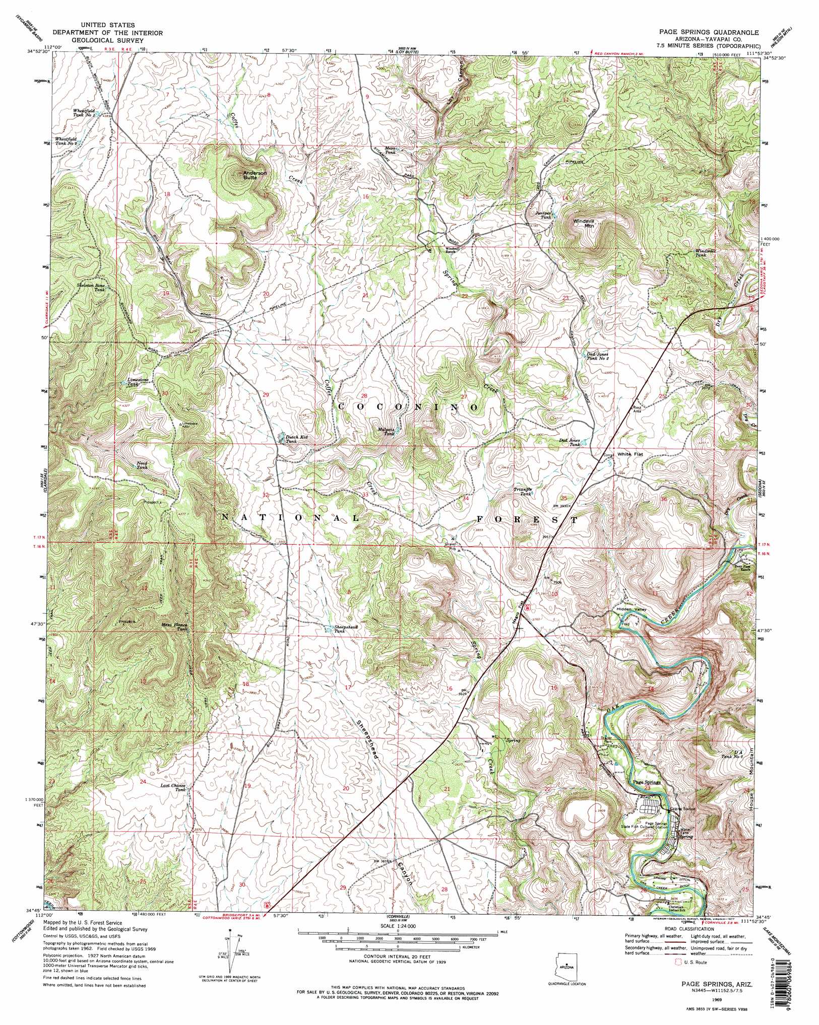
USGS Topo Quad 34111g8 - 1:24,000 scale
| Topo Map Name: | Page Springs |
| USGS Topo Quad ID: | 34111g8 |
| Print Size: | ca. 21 1/4" wide x 27" high |
| Southeast Coordinates: | 34.75° N latitude / 111.875° W longitude |
| Map Center Coordinates: | 34.8125° N latitude / 111.9375° W longitude |
| U.S. State: | AZ |
| Filename: | o34111g8.jpg |
| Download Map JPG Image: | Page Springs topo map 1:24,000 scale |
| Map Type: | Topographic |
| Topo Series: | 7.5´ |
| Map Scale: | 1:24,000 |
| Source of Map Images: | United States Geological Survey (USGS) |
| Alternate Map Versions: |
Page Springs AZ 1969, updated 1971 Download PDF Buy paper map Page Springs AZ 1969, updated 1977 Download PDF Buy paper map Page Springs AZ 1969, updated 1977 Download PDF Buy paper map Page Springs AZ 1969, updated 1977 Download PDF Buy paper map Page Springs AZ 2011 Download PDF Buy paper map Page Springs AZ 2014 Download PDF Buy paper map |
| FStopo: | US Forest Service topo Page Springs is available: Download FStopo PDF Download FStopo TIF |
1:24,000 Topo Quads surrounding Page Springs
May Tank Pocket |
White Horse Lake |
Sycamore Point |
Dutton Hill |
Mountainaire |
Perkinsville |
Sycamore Basin |
Loy Butte |
Wilson Mountain |
Munds Park |
Munds Draw |
Clarkdale |
Page Springs |
Sedona |
Munds Mountain |
Hickey Mountain |
Cottonwood |
Cornville |
Lake Montezuma |
Casner Butte |
Humboldt |
Cherry |
Middle Verde |
Camp Verde |
Walker Mountain |
> Back to 34111e1 at 1:100,000 scale
> Back to 34110a1 at 1:250,000 scale
> Back to U.S. Topo Maps home
Page Springs topo map: Gazetteer
Page Springs: Basins
Hidden Valley elevation 1113m 3651′Page Springs: Canals
Spring Ditch elevation 1056m 3464′Page Springs: Flats
Negro Flat elevation 1150m 3772′White Flat elevation 1220m 4002′
Page Springs: Populated Places
Page Springs elevation 1071m 3513′Page Springs: Reservoirs
Anderson Tank elevation 1323m 4340′Box Tank elevation 1338m 4389′
D A Tank Number Two elevation 1304m 4278′
Dad Jones Tank elevation 1202m 3943′
Dad Jones Tank Number Two elevation 1215m 3986′
Dutch Kid Tank elevation 1220m 4002′
Evans Tank elevation 1183m 3881′
Jackass Tank elevation 1348m 4422′
Juniper Tank elevation 1289m 4229′
Last Chance Tank elevation 1110m 3641′
Limestone Tank elevation 1284m 4212′
Malpais Tank elevation 1200m 3937′
Mesa Blanco Tank elevation 1205m 3953′
Mesa Tank elevation 1285m 4215′
Need Tank elevation 1282m 4206′
Sheepshead Tank elevation 1166m 3825′
Skeleton Bone Tank elevation 1324m 4343′
Spider Tank elevation 1180m 3871′
Surprise Tank elevation 1193m 3914′
Triangle Tank elevation 1181m 3874′
Wheatfield Tank Number One elevation 1335m 4379′
Wheatfield Tank Number Two elevation 1326m 4350′
White Flat Tank elevation 1212m 3976′
Windmill Tank elevation 1276m 4186′
Page Springs: Streams
Coffee Creek elevation 1153m 3782′Dry Creek elevation 1124m 3687′
Page Springs: Summits
Anderson Butte elevation 1399m 4589′Windmill Mountain elevation 1417m 4648′
Page Springs: Valleys
Loy Canyon elevation 1271m 4169′Page Springs digital topo map on disk
Buy this Page Springs topo map showing relief, roads, GPS coordinates and other geographical features, as a high-resolution digital map file on DVD: