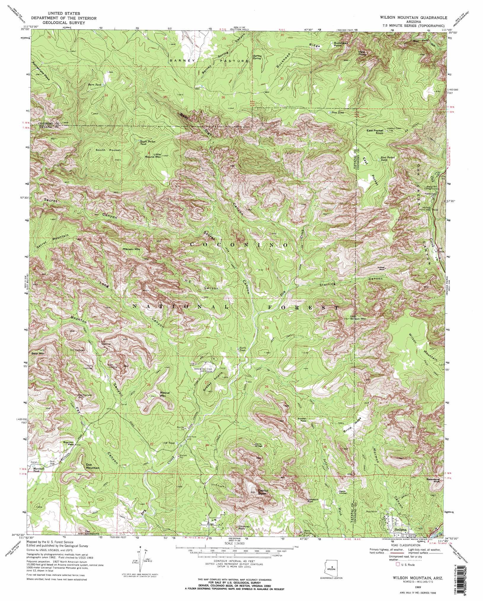
Wilson Mountain Topo Map Arizona
To zoom in, hover over the map of Wilson Mountain
USGS Topo Quad 34111h7 - 1:24,000 scale
| Topo Map Name: | Wilson Mountain |
| USGS Topo Quad ID: | 34111h7 |
| Print Size: | ca. 21 1/4" wide x 27" high |
| Southeast Coordinates: | 34.875° N latitude / 111.75° W longitude |
| Map Center Coordinates: | 34.9375° N latitude / 111.8125° W longitude |
| U.S. State: | AZ |
| Filename: | o34111h7.jpg |
| Download Map JPG Image: | Wilson Mountain topo map 1:24,000 scale |
| Map Type: | Topographic |
| Topo Series: | 7.5´ |
| Map Scale: | 1:24,000 |
| Source of Map Images: | United States Geological Survey (USGS) |
| Alternate Map Versions: |
Wilson Mountain AZ 1969, updated 1972 Download PDF Buy paper map Wilson Mountain AZ 1969, updated 1972 Download PDF Buy paper map Wilson Mountain AZ 2011 Download PDF Buy paper map Wilson Mountain AZ 2014 Download PDF Buy paper map |
| FStopo: | US Forest Service topo Wilson Mountain is available: Download FStopo PDF Download FStopo TIF |
1:24,000 Topo Quads surrounding Wilson Mountain
Davenport Hill |
Garland Prairie |
Bellemont |
Flagstaff West |
Flagstaff East |
White Horse Lake |
Sycamore Point |
Dutton Hill |
Mountainaire |
Lower Lake Mary |
Sycamore Basin |
Loy Butte |
Wilson Mountain |
Munds Park |
Mormon Mountain |
Clarkdale |
Page Springs |
Sedona |
Munds Mountain |
Stoneman Lake |
Cottonwood |
Cornville |
Lake Montezuma |
Casner Butte |
Apache Maid Mountain |
> Back to 34111e1 at 1:100,000 scale
> Back to 34110a1 at 1:250,000 scale
> Back to U.S. Topo Maps home
Wilson Mountain topo map: Gazetteer
Wilson Mountain: Arches
Devils Bridge elevation 1482m 4862′Fay Canyon Arch elevation 1491m 4891′
Indian Head Arch elevation 1600m 5249′
Vultee Arch elevation 1670m 5479′
Wilson Mountain: Areas
Barney Pasture elevation 2088m 6850′Barney Pasture Burn elevation 2079m 6820′
Devils Kitchen elevation 1367m 4484′
Wilson Mountain: Basins
East Pocket elevation 2100m 6889′South Pocket elevation 2043m 6702′
Wilson Mountain: Cliffs
Buckhead Point elevation 1869m 6131′View Point elevation 2127m 6978′
Wilson Mountain: Gaps
Boynton Pass elevation 1416m 4645′Soldier Pass elevation 1498m 4914′
Wilson Mountain: Parks
Halfway Picnic Area elevation 1535m 5036′Slide Rock Swim Area elevation 1498m 4914′
Wilson Mountain: Reservoirs
AM Tank elevation 1860m 6102′Buckshead Tank elevation 2105m 6906′
Burn Tank elevation 2091m 6860′
Crater Tank elevation 2105m 6906′
Earls Tank elevation 1415m 4642′
East Pocket Tank elevation 2092m 6863′
First Tank elevation 2093m 6866′
Hancock Cabin Tank elevation 2073m 6801′
Lil Round Tank elevation 2098m 6883′
Loy Tank elevation 2084m 6837′
Marshall Tank elevation 1382m 4534′
Mos Tank elevation 2065m 6774′
OK Tank elevation 1361m 4465′
Pine Tank elevation 2084m 6837′
Rattlesnake Tank elevation 2096m 6876′
South Pocket Tank elevation 2000m 6561′
Test Hole Tank elevation 1453m 4767′
Wilson Tank elevation 2034m 6673′
Wilson Mountain: Ridges
Buckhead Ridge elevation 2115m 6938′Wilson Mountain: Springs
Barney Spring elevation 2069m 6788′Wilson Mountain: Summits
Brins Mesa elevation 1659m 5442′Capitol Butte elevation 1933m 6341′
Chimney Rock elevation 1569m 5147′
Coffeepot Rock elevation 1599m 5246′
Doe Mountain elevation 1554m 5098′
East Pocket Knob elevation 2190m 7185′
Grassy Knolls elevation 1484m 4868′
Little Round Mountain elevation 2118m 6948′
Lost Wilson Mountain elevation 2066m 6778′
Maroon Mountain elevation 2030m 6660′
Mescal Mountain elevation 1537m 5042′
Rattlesnake Mesa elevation 2124m 6968′
Round Top Mountain elevation 1846m 6056′
Steamboat Rock elevation 1638m 5374′
The Cockscomb elevation 1529m 5016′
Wilson Mountain elevation 2164m 7099′
Wilson Mountain: Trails
Bridle Trail elevation 1429m 4688′Vultee Arch Twenty Two elevation 1537m 5042′
Wilson Mountain: Valleys
Bear Sign Canyon elevation 1486m 4875′Boynton Canyon elevation 1341m 4399′
Fay Canyon elevation 1329m 4360′
H S Canyon elevation 1437m 4714′
Long Canyon elevation 1346m 4416′
Secret Canyon elevation 1424m 4671′
Sterling Canyon elevation 1459m 4786′
Wilson Mountain digital topo map on disk
Buy this Wilson Mountain topo map showing relief, roads, GPS coordinates and other geographical features, as a high-resolution digital map file on DVD: