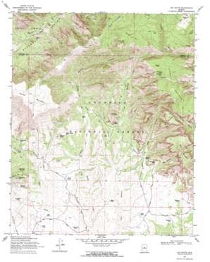
Loy Butte Topo Map Arizona
To zoom in, hover over the map of Loy Butte
USGS Topo Quad 34111h8 - 1:24,000 scale
| Topo Map Name: | Loy Butte |
| USGS Topo Quad ID: | 34111h8 |
| Print Size: | ca. 21 1/4" wide x 27" high |
| Southeast Coordinates: | 34.875° N latitude / 111.875° W longitude |
| Map Center Coordinates: | 34.9375° N latitude / 111.9375° W longitude |
| U.S. State: | AZ |
| Filename: | o34111h8.jpg |
| Download Map JPG Image: | Loy Butte topo map 1:24,000 scale |
| Map Type: | Topographic |
| Topo Series: | 7.5´ |
| Map Scale: | 1:24,000 |
| Source of Map Images: | United States Geological Survey (USGS) |
| Alternate Map Versions: |
Loy Butte AZ 1970, updated 1972 Download PDF Buy paper map Loy Butte AZ 1970, updated 1972 Download PDF Buy paper map Loy Butte AZ 2012 Download PDF Buy paper map Loy Butte AZ 2014 Download PDF Buy paper map |
| FStopo: | US Forest Service topo Loy Butte is available: Download FStopo PDF Download FStopo TIF |
1:24,000 Topo Quads surrounding Loy Butte
> Back to 34111e1 at 1:100,000 scale
> Back to 34110a1 at 1:250,000 scale
> Back to U.S. Topo Maps home
Loy Butte topo map: Gazetteer
Loy Butte: Areas
Rattlesnake Burn elevation 2147m 7043′Loy Butte: Basins
Taylor Basin elevation 1391m 4563′Loy Butte: Cliffs
Dave Joy Point elevation 2010m 6594′Loy Butte: Gaps
Sycamore Pass elevation 1489m 4885′Loy Butte: Reservoirs
Black Tank elevation 1367m 4484′Cabin Tank elevation 1445m 4740′
Casner Mountain Tank elevation 1984m 6509′
Casner Mountain Tank elevation 1505m 4937′
Concrete Tank elevation 1951m 6400′
Corral Tank elevation 1384m 4540′
Dutch Kid Tank elevation 1391m 4563′
Gray Tank elevation 1320m 4330′
Grindstone Tank elevation 1423m 4668′
Huntley Tank elevation 1353m 4438′
Joe Tank elevation 2027m 6650′
Joes Tank elevation 1423m 4668′
Johnson Tank elevation 1972m 6469′
Lincoln Canyon Tank elevation 1415m 4642′
Masonry Tank elevation 1954m 6410′
Miller Tank elevation 1353m 4438′
Nolan Tank elevation 1359m 4458′
Red Tank elevation 1370m 4494′
Robbers Roost Tank elevation 1469m 4819′
Robinson Tank elevation 1370m 4494′
Sebra Tank elevation 1495m 4904′
Sugarloaf Tank Number One elevation 1424m 4671′
Sugarloaf Tank Number Two elevation 1459m 4786′
Taylor Basin Tank elevation 1365m 4478′
Taylor Tank elevation 1437m 4714′
Thomas Tank elevation 1335m 4379′
Underwood Tank elevation 1308m 4291′
Loy Butte: Springs
Bunker Hill Spring elevation 1951m 6400′Sycamore Spring elevation 1490m 4888′
Loy Butte: Summits
Bear Mountain elevation 1973m 6473′Bunker Hill elevation 2047m 6715′
Casner Mountain elevation 2079m 6820′
Lost Mountain elevation 2021m 6630′
Loy Butte elevation 1720m 5643′
Robbers Roost elevation 1559m 5114′
Secret Mountain elevation 2014m 6607′
Sugarloaf Mountain elevation 1652m 5419′
Loy Butte: Trails
Casner Mountain Trail Eight elevation 2022m 6633′Loy Butte Five elevation 1513m 4963′
Mooney Trail elevation 1457m 4780′
Loy Butte: Valleys
Hart Well Canyon elevation 1377m 4517′Jacks Canyon elevation 1326m 4350′
Lincoln Canyon elevation 1389m 4557′
Mooney Canyon elevation 1378m 4520′
Red Canyon elevation 1451m 4760′
Loy Butte: Wells
Nichols Well elevation 1431m 4694′Loy Butte digital topo map on disk
Buy this Loy Butte topo map showing relief, roads, GPS coordinates and other geographical features, as a high-resolution digital map file on DVD:


