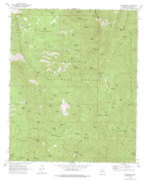
Minnehaha Topo Map Arizona
To zoom in, hover over the map of Minnehaha
USGS Topo Quad 34112b4 - 1:24,000 scale
| Topo Map Name: | Minnehaha |
| USGS Topo Quad ID: | 34112b4 |
| Print Size: | ca. 21 1/4" wide x 27" high |
| Southeast Coordinates: | 34.125° N latitude / 112.375° W longitude |
| Map Center Coordinates: | 34.1875° N latitude / 112.4375° W longitude |
| U.S. State: | AZ |
| Filename: | o34112b4.jpg |
| Download Map JPG Image: | Minnehaha topo map 1:24,000 scale |
| Map Type: | Topographic |
| Topo Series: | 7.5´ |
| Map Scale: | 1:24,000 |
| Source of Map Images: | United States Geological Survey (USGS) |
| Alternate Map Versions: |
Minnehaha AZ 1969, updated 1973 Download PDF Buy paper map Minnehaha AZ 1969, updated 1978 Download PDF Buy paper map Minnehaha AZ 1969, updated 1978 Download PDF Buy paper map Minnehaha AZ 2012 Download PDF Buy paper map Minnehaha AZ 2014 Download PDF Buy paper map |
| FStopo: | US Forest Service topo Minnehaha is available: Download FStopo PDF Download FStopo TIF |
1:24,000 Topo Quads surrounding Minnehaha
> Back to 34112a1 at 1:100,000 scale
> Back to 34112a1 at 1:250,000 scale
> Back to U.S. Topo Maps home
Minnehaha topo map: Gazetteer
Minnehaha: Basins
Cellar Basin elevation 1268m 4160′Minnehaha: Falls
Minnehaha Waters elevation 1500m 4921′Minnehaha: Flats
Johnson Flat elevation 1363m 4471′Minnehaha Flat elevation 1595m 5232′
Minnehaha: Gaps
Baldy Trap elevation 1321m 4333′Hooper Saddle elevation 1820m 5971′
Jakies Pass elevation 1799m 5902′
Minnehaha: Mines
Boaz Mine elevation 1596m 5236′Button Mine elevation 1694m 5557′
Camp Bird Mine elevation 1292m 4238′
Joker Mine elevation 1304m 4278′
Pacific Mine elevation 1430m 4691′
Silver Dollar Mine elevation 1259m 4130′
Minnehaha: Populated Places
Chilean Mill elevation 1485m 4872′Lapham elevation 1601m 5252′
Minnehaha elevation 1667m 5469′
Paxton Place elevation 1202m 3943′
Minnehaha: Ranges
McAllister Range elevation 1498m 4914′Minnehaha: Reservoirs
LF Tank elevation 1317m 4320′Minnehaha: Ridges
LF Ridge elevation 1325m 4347′Minnehaha: Springs
Ash Spring elevation 1339m 4393′Black Jack Spring elevation 1468m 4816′
Boulder Dam Spring elevation 1613m 5291′
Box Spring elevation 1546m 5072′
Bull Run Spring elevation 1641m 5383′
Cedar Spring elevation 1387m 4550′
Cellar Springs elevation 1205m 3953′
Charles Spring elevation 1307m 4288′
Cherry Spring elevation 1129m 3704′
Cherry Trap Spring elevation 1391m 4563′
Colorado Spring elevation 1370m 4494′
Escondido Spring elevation 1437m 4714′
Goodwin Spring elevation 1176m 3858′
Grapevine Spring elevation 1494m 4901′
Horse Mountain Spring elevation 2025m 6643′
House Water Spring elevation 1216m 3989′
Indian Springs elevation 1256m 4120′
Jakies Pass Spring elevation 1669m 5475′
John Spring elevation 1387m 4550′
Johnson Flat Spring elevation 1368m 4488′
Juniper Spring elevation 1397m 4583′
Lane Spring elevation 1245m 4084′
Little Joker Spring elevation 1297m 4255′
Log Cabin Spring elevation 1354m 4442′
Logan Mine Spring elevation 1438m 4717′
Lucky Spring elevation 1360m 4461′
Minnehaha Spring elevation 1219m 3999′
Minnehaha Spring elevation 1597m 5239′
Oak Creek Spring elevation 1257m 4124′
Patterson Spring elevation 1770m 5807′
Pay Dirt Spring elevation 1643m 5390′
Peter Spring elevation 1464m 4803′
Purebred Spring elevation 1237m 4058′
Rabbit Spring elevation 1235m 4051′
Ralphs Spring elevation 1300m 4265′
Ridges Spring elevation 1208m 3963′
Rock Spring elevation 1191m 3907′
Rush Spring elevation 1671m 5482′
Silver Dollar Spring elevation 1242m 4074′
Steamboat Spring elevation 1395m 4576′
TB Spring elevation 1425m 4675′
Tetterman Spring elevation 1356m 4448′
Willow Spring elevation 1455m 4773′
Y Spring elevation 1454m 4770′
Minnehaha: Streams
Ash Creek elevation 1524m 5000′Indian Springs Creek elevation 1180m 3871′
North Fork Cellar Springs Creek elevation 1203m 3946′
Pine Creek elevation 1565m 5134′
South Fork Cellar Springs Creek elevation 1206m 3956′
Minnehaha: Summits
Horse Mountain elevation 2127m 6978′Silver Mountain elevation 1866m 6122′
The Cements elevation 1432m 4698′
Thompson Butte elevation 1587m 5206′
Minnehaha: Trails
Cellar Basin Trail elevation 1241m 4071′Cherry Creek Trail Two Hundred Fourteen elevation 1249m 4097′
Horse Mountain Trail Number Two Hundred Twelve elevation 2027m 6650′
Wagoner Trail Number Two Hundred Thirteen elevation 1540m 5052′
Minnehaha: Valleys
Wheels Canyon elevation 1391m 4563′Minnehaha: Wells
Camp Bird Well elevation 1273m 4176′Oak Creek Well elevation 1420m 4658′
Minnehaha digital topo map on disk
Buy this Minnehaha topo map showing relief, roads, GPS coordinates and other geographical features, as a high-resolution digital map file on DVD:


