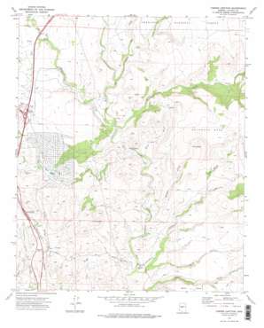
Cordes Junction Topo Map Arizona
To zoom in, hover over the map of Cordes Junction
USGS Topo Quad 34112c1 - 1:24,000 scale
| Topo Map Name: | Cordes Junction |
| USGS Topo Quad ID: | 34112c1 |
| Print Size: | ca. 21 1/4" wide x 27" high |
| Southeast Coordinates: | 34.25° N latitude / 112° W longitude |
| Map Center Coordinates: | 34.3125° N latitude / 112.0625° W longitude |
| U.S. State: | AZ |
| Filename: | o34112c1.jpg |
| Download Map JPG Image: | Cordes Junction topo map 1:24,000 scale |
| Map Type: | Topographic |
| Topo Series: | 7.5´ |
| Map Scale: | 1:24,000 |
| Source of Map Images: | United States Geological Survey (USGS) |
| Alternate Map Versions: |
Cordes Junction AZ 1974, updated 1977 Download PDF Buy paper map Cordes Junction AZ 1974, updated 1977 Download PDF Buy paper map Cordes Junction AZ 2012 Download PDF Buy paper map Cordes Junction AZ 2014 Download PDF Buy paper map |
| FStopo: | US Forest Service topo Cordes Junction is available: Download FStopo PDF Download FStopo TIF |
1:24,000 Topo Quads surrounding Cordes Junction
> Back to 34112a1 at 1:100,000 scale
> Back to 34112a1 at 1:250,000 scale
> Back to U.S. Topo Maps home
Cordes Junction topo map: Gazetteer
Cordes Junction: Basins
Cactus Basin elevation 1188m 3897′Cordes Junction: Crossings
Bloody Basin Interchange elevation 1128m 3700′Cordes Junction Interchange elevation 1157m 3795′
Cordes Junction: Populated Places
Arcosanti elevation 1139m 3736′Cordes Junction elevation 1159m 3802′
Cordes Lakes elevation 1126m 3694′
Cordes Junction: Streams
Ash Creek elevation 1068m 3503′Big Bug Creek elevation 1055m 3461′
Black Hill Wash elevation 1047m 3435′
Dry Creek elevation 1106m 3628′
Indian Creek elevation 998m 3274′
Little Ash Creek elevation 1085m 3559′
Sycamore Creek elevation 1068m 3503′
Cordes Junction: Summits
Sycamore Mesa elevation 1382m 4534′Cordes Junction: Valleys
Long Gulch elevation 1000m 3280′Red Rock Gulch elevation 1084m 3556′
Sheep Gulch elevation 1012m 3320′
Cordes Junction digital topo map on disk
Buy this Cordes Junction topo map showing relief, roads, GPS coordinates and other geographical features, as a high-resolution digital map file on DVD:


