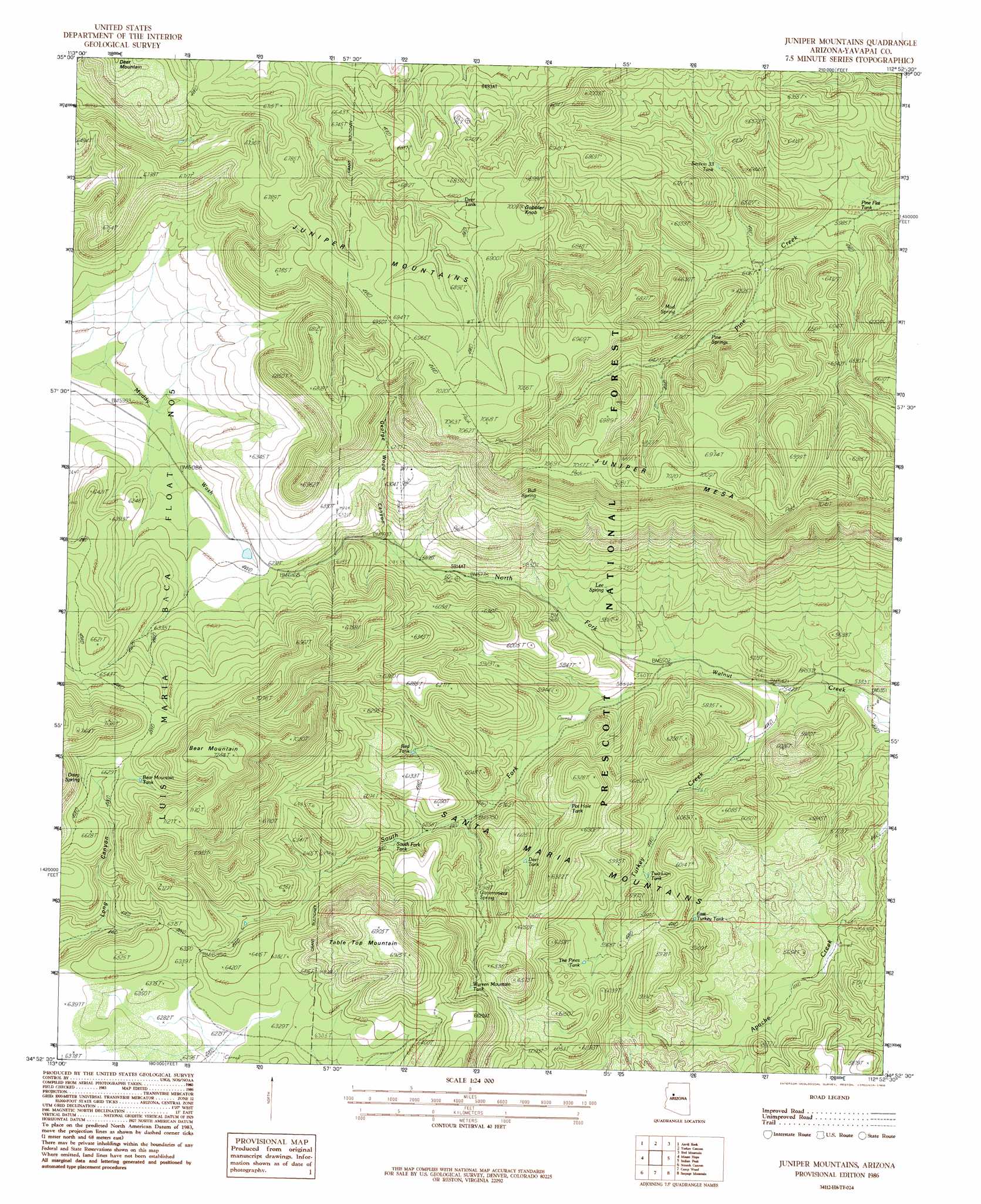
Juniper Mountains Topo Map Arizona
To zoom in, hover over the map of Juniper Mountains
USGS Topo Quad 34112h8 - 1:24,000 scale
| Topo Map Name: | Juniper Mountains |
| USGS Topo Quad ID: | 34112h8 |
| Print Size: | ca. 21 1/4" wide x 27" high |
| Southeast Coordinates: | 34.875° N latitude / 112.875° W longitude |
| Map Center Coordinates: | 34.9375° N latitude / 112.9375° W longitude |
| U.S. State: | AZ |
| Filename: | o34112h8.jpg |
| Download Map JPG Image: | Juniper Mountains topo map 1:24,000 scale |
| Map Type: | Topographic |
| Topo Series: | 7.5´ |
| Map Scale: | 1:24,000 |
| Source of Map Images: | United States Geological Survey (USGS) |
| Alternate Map Versions: |
Juniper Mountains AZ 1986, updated 1986 Download PDF Buy paper map Juniper Mountains AZ 1986, updated 1986 Download PDF Buy paper map Juniper Mountains AZ 2012 Download PDF Buy paper map Juniper Mountains AZ 2014 Download PDF Buy paper map |
| FStopo: | US Forest Service topo Juniper Mountains is available: Download FStopo PDF Download FStopo TIF |
1:24,000 Topo Quads surrounding Juniper Mountains
Cross Mountain |
Squaw Peak |
Purcell Canyon |
Turkey Canyon Ne |
Picacho Butte |
Anvil Rock Ranch |
Anvil Rock |
Turkey Canyon |
Red Mountain |
South Butte |
Sunrise Peak |
Mount Hope |
Juniper Mountains |
Indian Peak |
Limestone Peak |
Burro Mesa |
Scratch Canyon |
Camp Wood |
Seepage Mountain |
Simmons |
Bozarth Mesa |
Behm Mesa |
Sheridan Mountain |
Smith Mesa |
Mount Josh |
> Back to 34112e1 at 1:100,000 scale
> Back to 34112a1 at 1:250,000 scale
> Back to U.S. Topo Maps home
Juniper Mountains topo map: Gazetteer
Juniper Mountains: Reservoirs
Bear Mountain Tank elevation 2035m 6676′Deer Tank elevation 1815m 5954′
Deer Tank elevation 2068m 6784′
East Turkey Tank elevation 1729m 5672′
Juniper Catchment elevation 2101m 6893′
Juniper Trick Tank elevation 2085m 6840′
Pine Flat Tank elevation 1815m 5954′
Pot Hole Tank elevation 1830m 6003′
Red Tank elevation 1815m 5954′
Section Thirtythree Tank elevation 1890m 6200′
Seep Tank elevation 1888m 6194′
South Fork Tank elevation 1805m 5921′
The Pines Tank elevation 1781m 5843′
Trick Tank elevation 1817m 5961′
Two Lion Tank elevation 1740m 5708′
Warren Mountain Tank elevation 1927m 6322′
Juniper Mountains: Springs
Apache Creek Seep elevation 1644m 5393′Bull Spring elevation 2011m 6597′
Dairy Spring elevation 2016m 6614′
Datry Spring elevation 2016m 6614′
Government Spring elevation 1814m 5951′
Lee Spring elevation 1753m 5751′
Little Old Spring elevation 1676m 5498′
Mud Spring elevation 1923m 6309′
Pine Spring elevation 1890m 6200′
Pine Springs elevation 1920m 6299′
Juniper Mountains: Streams
North Fork Walnut Creek elevation 1671m 5482′South Fork Walnut Creek elevation 1673m 5488′
Turkey Creek elevation 1645m 5396′
Juniper Mountains: Summits
Bear Mountain elevation 2208m 7244′Gobbler Knob elevation 2108m 6916′
Juniper Mesa elevation 2118m 6948′
Table Top Mountain elevation 2104m 6902′
Juniper Mountains: Valleys
George Wood Canyon elevation 1794m 5885′Juniper Mountains: Wells
Turkey Creek Well elevation 1708m 5603′Juniper Mountains digital topo map on disk
Buy this Juniper Mountains topo map showing relief, roads, GPS coordinates and other geographical features, as a high-resolution digital map file on DVD: