Arrastra Mountain Ne Topo Map Arizona
To zoom in, hover over the map of Arrastra Mountain Ne
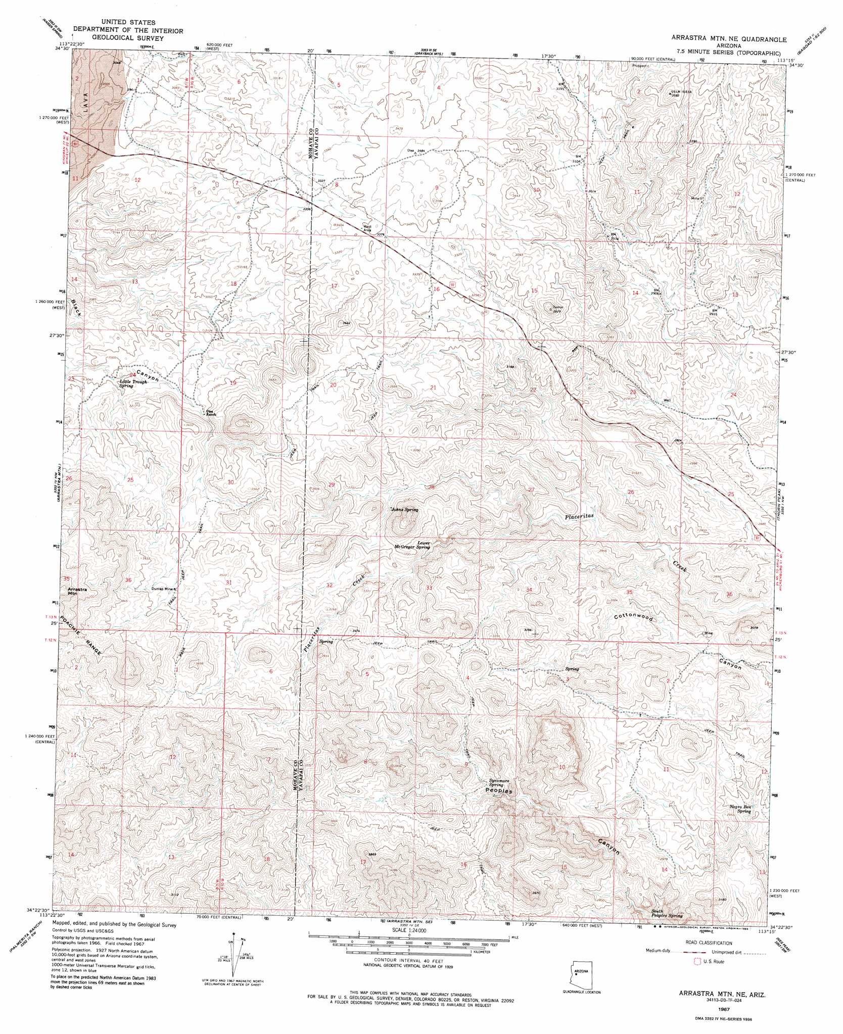
USGS Topo Quad 34113d3 - 1:24,000 scale
| Topo Map Name: | Arrastra Mountain Ne |
| USGS Topo Quad ID: | 34113d3 |
| Print Size: | ca. 21 1/4" wide x 27" high |
| Southeast Coordinates: | 34.375° N latitude / 113.25° W longitude |
| Map Center Coordinates: | 34.4375° N latitude / 113.3125° W longitude |
| U.S. State: | AZ |
| Filename: | o34113d3.jpg |
| Download Map JPG Image: | Arrastra Mountain Ne topo map 1:24,000 scale |
| Map Type: | Topographic |
| Topo Series: | 7.5´ |
| Map Scale: | 1:24,000 |
| Source of Map Images: | United States Geological Survey (USGS) |
| Alternate Map Versions: |
Arrastra Mtn NE AZ 1967, updated 1969 Download PDF Buy paper map Arrastra Mtn NE AZ 1967, updated 1985 Download PDF Buy paper map Arrastra Mountain NE AZ 2011 Download PDF Buy paper map Arrastra Mountain NE AZ 2014 Download PDF Buy paper map |
1:24,000 Topo Quads surrounding Arrastra Mountain Ne
Wikieup |
Elephant Mountain |
Negro Ed |
Bozarth Mesa |
Behm Mesa |
Greenwood Peak |
Kaiser Spring |
Grayback Mountains |
Bagdad |
Big Shipp Mountain |
Signal Mountain |
Arrastra Mountain |
Arrastra Mountain Ne |
Thorn Peak |
Malpais Mesa Ne |
Artillery Peak |
Palmerita Ranch |
Arrastra Mountain Se |
Ives Peak |
Malpais Mesa |
Alamo Dam |
Smith Peak Nw |
Smith Peak Ne |
Date Creek Ranch Nw |
Date Creek Ranch |
> Back to 34113a1 at 1:100,000 scale
> Back to 34112a1 at 1:250,000 scale
> Back to U.S. Topo Maps home
Arrastra Mountain Ne topo map: Gazetteer
Arrastra Mountain Ne: Mines
Dunlap Mine elevation 1070m 3510′Arrastra Mountain Ne: Springs
Johns Spring elevation 948m 3110′Little Trough Spring elevation 910m 2985′
Lower McGregor Spring elevation 907m 2975′
Negro Ben Spring elevation 825m 2706′
South Peoples Spring elevation 757m 2483′
Sycamore Spring elevation 923m 3028′
Arrastra Mountain Ne digital topo map on disk
Buy this Arrastra Mountain Ne topo map showing relief, roads, GPS coordinates and other geographical features, as a high-resolution digital map file on DVD: