Mount Hope Topo Map Arizona
To zoom in, hover over the map of Mount Hope
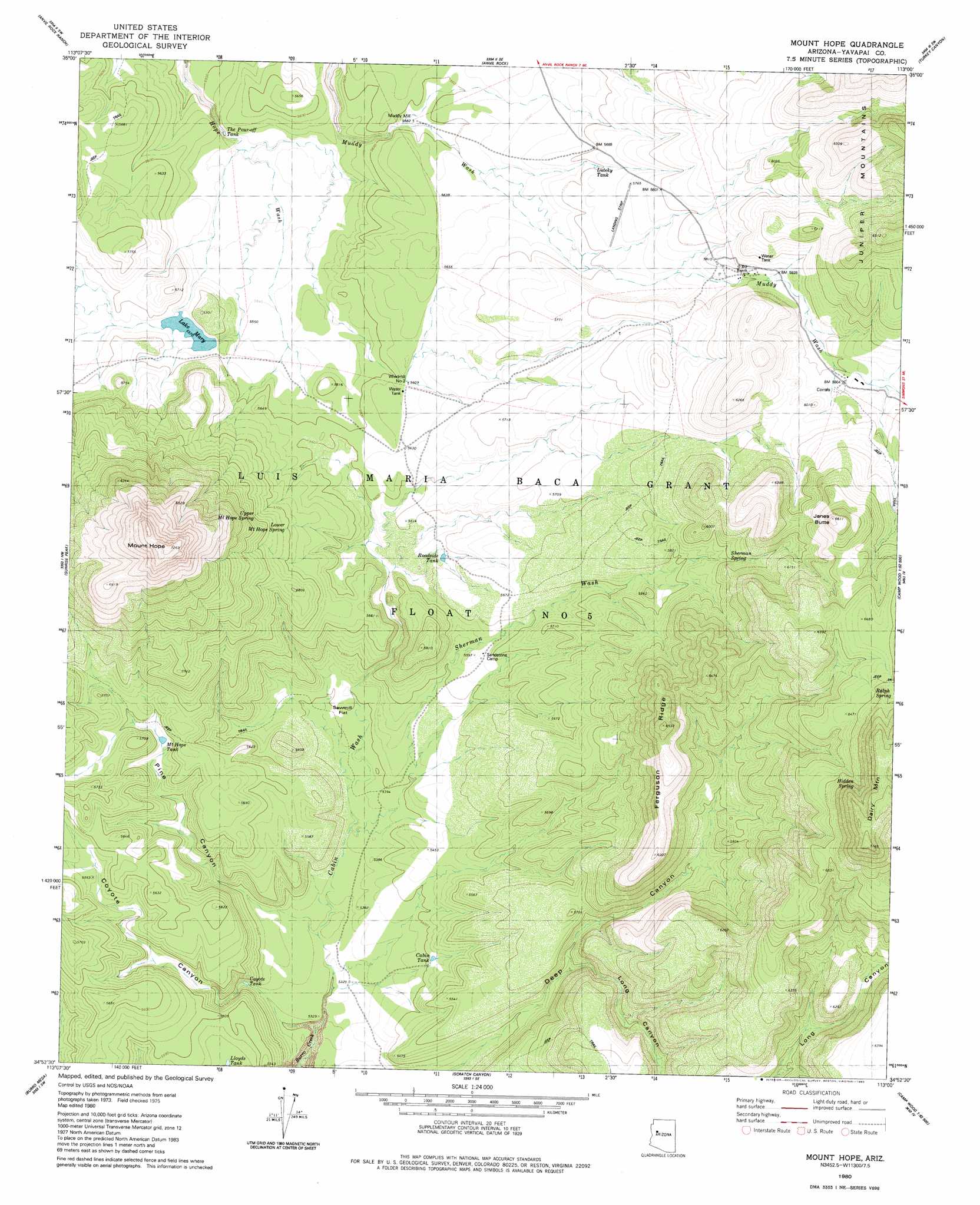
USGS Topo Quad 34113h1 - 1:24,000 scale
| Topo Map Name: | Mount Hope |
| USGS Topo Quad ID: | 34113h1 |
| Print Size: | ca. 21 1/4" wide x 27" high |
| Southeast Coordinates: | 34.875° N latitude / 113° W longitude |
| Map Center Coordinates: | 34.9375° N latitude / 113.0625° W longitude |
| U.S. State: | AZ |
| Filename: | o34113h1.jpg |
| Download Map JPG Image: | Mount Hope topo map 1:24,000 scale |
| Map Type: | Topographic |
| Topo Series: | 7.5´ |
| Map Scale: | 1:24,000 |
| Source of Map Images: | United States Geological Survey (USGS) |
| Alternate Map Versions: |
Mount Hope AZ 1980, updated 1980 Download PDF Buy paper map Mount Hope AZ 2011 Download PDF Buy paper map Mount Hope AZ 2014 Download PDF Buy paper map |
1:24,000 Topo Quads surrounding Mount Hope
Fort Rock Ranch |
Cross Mountain |
Squaw Peak |
Purcell Canyon |
Turkey Canyon Ne |
Devils Hump |
Anvil Rock Ranch |
Anvil Rock |
Turkey Canyon |
Red Mountain |
Mohon Peak |
Sunrise Peak |
Mount Hope |
Juniper Mountains |
Indian Peak |
Pilot Knob |
Burro Mesa |
Scratch Canyon |
Camp Wood |
Seepage Mountain |
Negro Ed |
Bozarth Mesa |
Behm Mesa |
Sheridan Mountain |
Smith Mesa |
> Back to 34113e1 at 1:100,000 scale
> Back to 34112a1 at 1:250,000 scale
> Back to U.S. Topo Maps home
Mount Hope topo map: Gazetteer
Mount Hope: Arroyos
Sherman Wash elevation 1635m 5364′Mount Hope: Flats
Sawmill Flat elevation 1643m 5390′Mount Hope: Reservoirs
Cabin Tank elevation 1648m 5406′Coyote Tank elevation 1631m 5351′
Lake Mary elevation 1702m 5583′
Lloyds Tank elevation 1662m 5452′
Luteky Tank elevation 1737m 5698′
Mount Hope Tank elevation 1698m 5570′
Roadside Tank elevation 1705m 5593′
The Pour-Off Tank elevation 1674m 5492′
Mount Hope: Ridges
Ferguson Ridge elevation 1991m 6532′Mount Hope: Springs
Hidden Spring elevation 2001m 6564′Lower Mount Hope Spring elevation 1739m 5705′
Ralph Spring elevation 1982m 6502′
Sherman Spring elevation 1796m 5892′
Upper Mount Hope Spring elevation 1768m 5800′
Mount Hope: Summits
Dairy Mountain elevation 2167m 7109′Janes Butte elevation 2016m 6614′
Mount Hope elevation 2205m 7234′
Mount Hope: Valleys
Cabin Wash elevation 1618m 5308′Coyote Canyon elevation 1547m 5075′
Long Canyon elevation 1714m 5623′
Pine Canyon elevation 1626m 5334′
Mount Hope: Wells
Muddy Mill elevation 1702m 5583′Windmill Number Two elevation 1711m 5613′
Mount Hope digital topo map on disk
Buy this Mount Hope topo map showing relief, roads, GPS coordinates and other geographical features, as a high-resolution digital map file on DVD: