Pilgrim Wash Topo Map Arizona
To zoom in, hover over the map of Pilgrim Wash
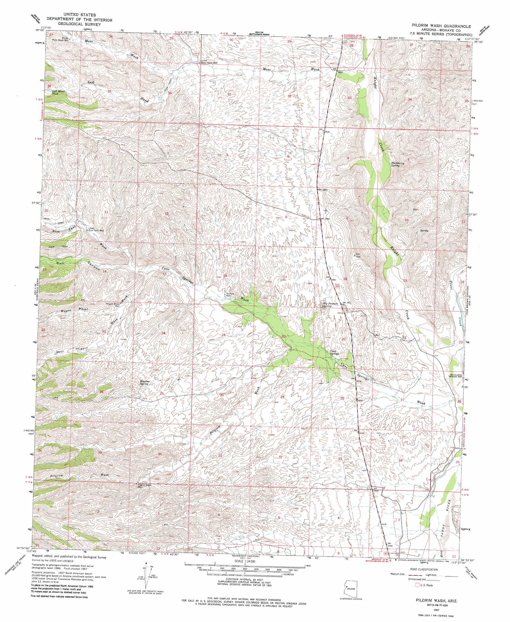
USGS Topo Quad 34113h6 - 1:24,000 scale
| Topo Map Name: | Pilgrim Wash |
| USGS Topo Quad ID: | 34113h6 |
| Print Size: | ca. 21 1/4" wide x 27" high |
| Southeast Coordinates: | 34.875° N latitude / 113.625° W longitude |
| Map Center Coordinates: | 34.9375° N latitude / 113.6875° W longitude |
| U.S. State: | AZ |
| Filename: | o34113h6.jpg |
| Download Map JPG Image: | Pilgrim Wash topo map 1:24,000 scale |
| Map Type: | Topographic |
| Topo Series: | 7.5´ |
| Map Scale: | 1:24,000 |
| Source of Map Images: | United States Geological Survey (USGS) |
| Alternate Map Versions: |
Pilgrim Wash AZ 1967, updated 1969 Download PDF Buy paper map Pilgrim Wash AZ 2011 Download PDF Buy paper map Pilgrim Wash AZ 2014 Download PDF Buy paper map |
1:24,000 Topo Quads surrounding Pilgrim Wash
Rattlesnake Hill |
Hualapai Spring |
Tin Mountain Nw |
Tin Mountain |
Bull Spring |
Hualapai Peak |
Dean Peak |
Bottleneck Wash |
Austin Peak |
Penitentiary Mountain |
Wabayuma Peak |
Hibernia Peak |
Pilgrim Wash |
Tom Brown Canyon |
Gonzales Wash |
Creamery Canyon |
Diamond Joe Peak |
Gunsight Canyon |
Tule Wash |
Cedar Basin |
Dutch Flat Nw |
Beecher Canyon |
Aubrey Peak |
Wikieup |
Elephant Mountain |
> Back to 34113e1 at 1:100,000 scale
> Back to 34112a1 at 1:250,000 scale
> Back to U.S. Topo Maps home
Pilgrim Wash topo map: Gazetteer
Pilgrim Wash: Reservoirs
Left Hand Tank elevation 1129m 3704′Pilgrim Wash: Springs
Big Pasture Spring elevation 841m 2759′Cane Springs elevation 815m 2673′
Hackberry Spring elevation 819m 2687′
Higgins Spring elevation 1012m 3320′
Kaiser Wash Spring elevation 860m 2821′
Pilgrim Wash: Streams
Blue Tank Wash elevation 914m 2998′Hair Clipper Wash elevation 885m 2903′
Knight Creek elevation 740m 2427′
Left Hand Moss Wash elevation 999m 3277′
Moss Wash elevation 854m 2801′
Pilgrim Wash elevation 817m 2680′
Trout Creek elevation 740m 2427′
Wagon Wheel Wash elevation 927m 3041′
Pilgrim Wash: Valleys
Cone Wash elevation 885m 2903′Pilgrim Wash: Wells
Lower Blue Tank Well elevation 946m 3103′Lower Moss Wash Well elevation 976m 3202′
Middle Moss Wash Well elevation 1094m 3589′
Pilgrim Wash Well elevation 1048m 3438′
Twomile Well elevation 850m 2788′
Wagon Wheel Well elevation 947m 3106′
Pilgrim Wash digital topo map on disk
Buy this Pilgrim Wash topo map showing relief, roads, GPS coordinates and other geographical features, as a high-resolution digital map file on DVD: