Yucca Valley South Topo Map California
To zoom in, hover over the map of Yucca Valley South
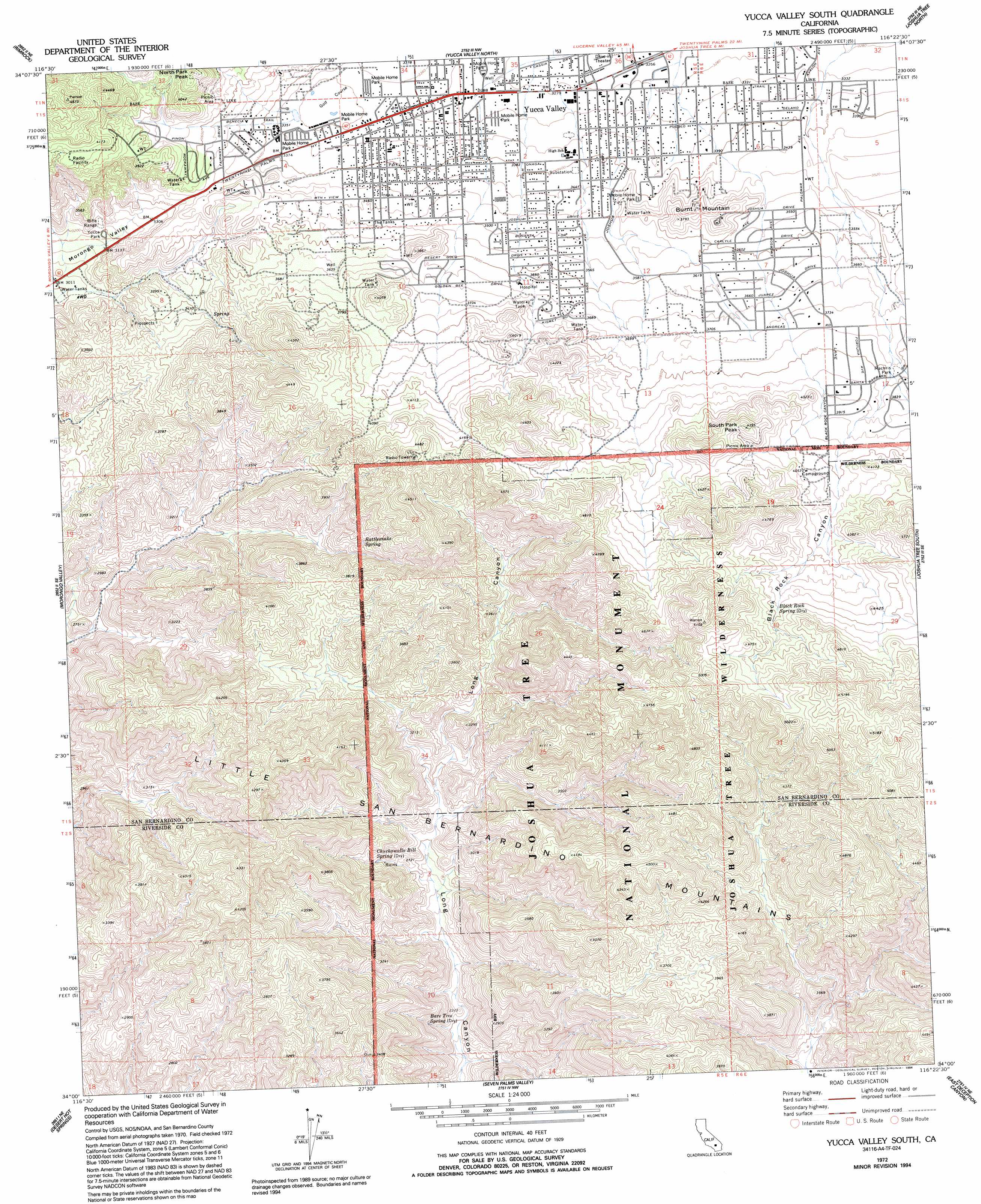
USGS Topo Quad 34116a4 - 1:24,000 scale
| Topo Map Name: | Yucca Valley South |
| USGS Topo Quad ID: | 34116a4 |
| Print Size: | ca. 21 1/4" wide x 27" high |
| Southeast Coordinates: | 34° N latitude / 116.375° W longitude |
| Map Center Coordinates: | 34.0625° N latitude / 116.4375° W longitude |
| U.S. State: | CA |
| Filename: | o34116a4.jpg |
| Download Map JPG Image: | Yucca Valley South topo map 1:24,000 scale |
| Map Type: | Topographic |
| Topo Series: | 7.5´ |
| Map Scale: | 1:24,000 |
| Source of Map Images: | United States Geological Survey (USGS) |
| Alternate Map Versions: |
Yucca Valley South CA 1972, updated 1975 Download PDF Buy paper map Yucca Valley South CA 1972, updated 1982 Download PDF Buy paper map Yucca Valley South CA 1972, updated 1994 Download PDF Buy paper map Yucca Valley South CA 1972, updated 1994 Download PDF Buy paper map Yucca Valley South CA 2012 Download PDF Buy paper map Yucca Valley South CA 2015 Download PDF Buy paper map |
1:24,000 Topo Quads surrounding Yucca Valley South
Rattlesnake Canyon |
Bighorn Canyon |
Landers |
Goat Mountain |
Deadman Lake Sw |
Onyx Peak |
Rimrock |
Yucca Valley North |
Joshua Tree North |
Sunfair |
Catclaw Flat |
Morongo Valley |
Yucca Valley South |
Joshua Tree South |
Indian Cove |
White Water |
Desert Hot Springs |
Seven Palms Valley |
East Deception Canyon |
Keys View |
San Jacinto Peak |
Palm Springs |
Cathedral City |
Myoma |
West Berdoo Canyon |
> Back to 34116a1 at 1:100,000 scale
> Back to 34116a1 at 1:250,000 scale
> Back to U.S. Topo Maps home
Yucca Valley South topo map: Gazetteer
Yucca Valley South: Parks
Community Center Park elevation 993m 3257′Hi Desert Park elevation 1038m 3405′
Joshua Drive Park elevation 1066m 3497′
Machris Park elevation 1150m 3772′
North Park elevation 1119m 3671′
South Park elevation 1263m 4143′
Traingle Park elevation 1013m 3323′
Tucca Park elevation 971m 3185′
Yucca Valley South: Populated Places
Yucca Valley elevation 1027m 3369′Yucca Valley South: Springs
Bare Tree Spring elevation 729m 2391′Black Rock Spring elevation 1331m 4366′
Chuckawalla Bill Spring elevation 852m 2795′
Rattlesnake Spring elevation 1085m 3559′
Yucca Valley South: Summits
Burnt Mountain elevation 1162m 3812′North Park Peak elevation 1260m 4133′
South Park Peak elevation 1332m 4370′
Yucca Valley South: Trails
Hi-View Nature Trail elevation 1303m 4274′Yucca Valley South: Valleys
Black Rock Canyon elevation 1156m 3792′Yucca Valley South digital topo map on disk
Buy this Yucca Valley South topo map showing relief, roads, GPS coordinates and other geographical features, as a high-resolution digital map file on DVD: