Catclaw Flat Topo Map California
To zoom in, hover over the map of Catclaw Flat
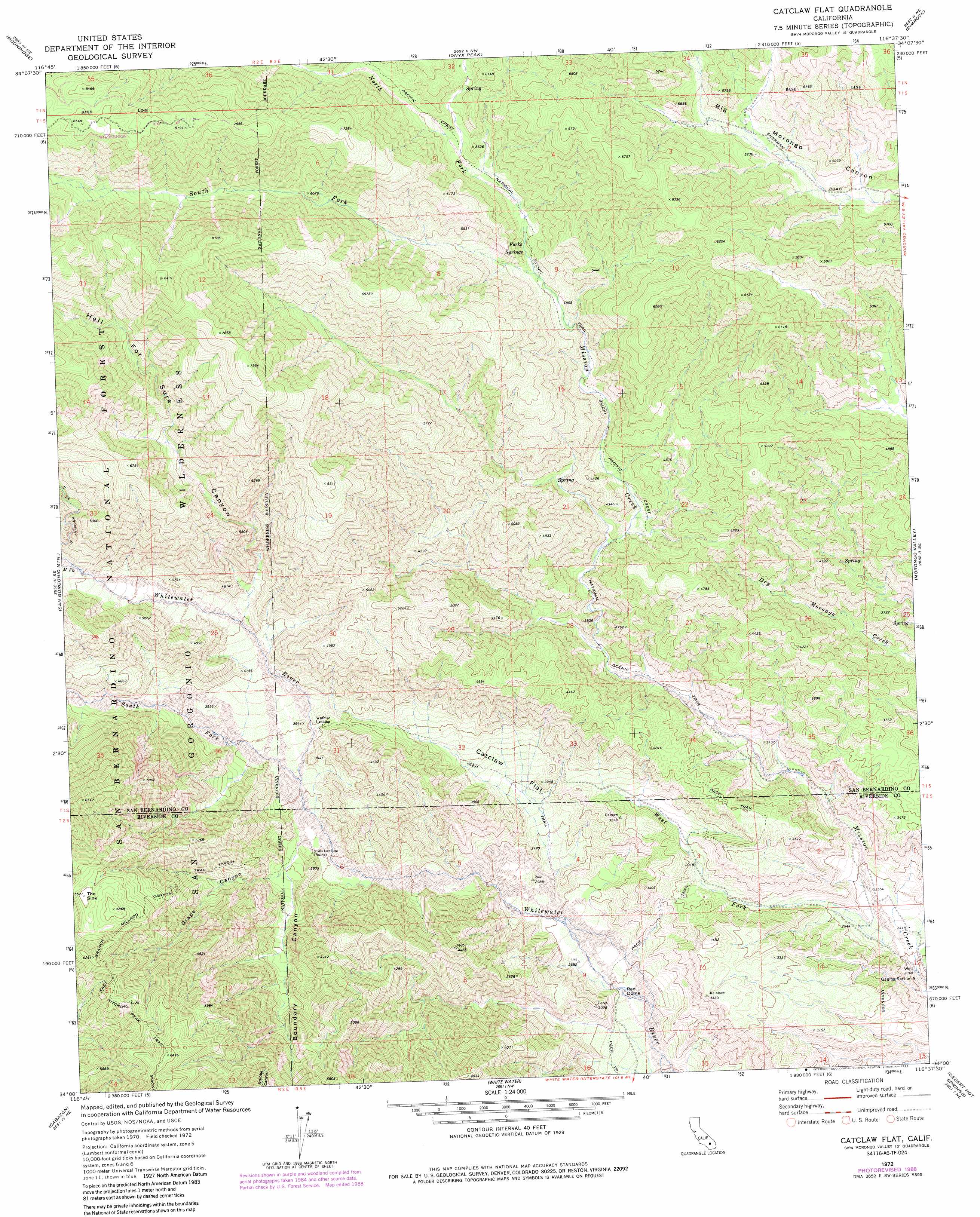
USGS Topo Quad 34116a6 - 1:24,000 scale
| Topo Map Name: | Catclaw Flat |
| USGS Topo Quad ID: | 34116a6 |
| Print Size: | ca. 21 1/4" wide x 27" high |
| Southeast Coordinates: | 34° N latitude / 116.625° W longitude |
| Map Center Coordinates: | 34.0625° N latitude / 116.6875° W longitude |
| U.S. State: | CA |
| Filename: | o34116a6.jpg |
| Download Map JPG Image: | Catclaw Flat topo map 1:24,000 scale |
| Map Type: | Topographic |
| Topo Series: | 7.5´ |
| Map Scale: | 1:24,000 |
| Source of Map Images: | United States Geological Survey (USGS) |
| Alternate Map Versions: |
Catclaw Flat CA 1972, updated 1975 Download PDF Buy paper map Catclaw Flat CA 1972, updated 1975 Download PDF Buy paper map Catclaw Flat CA 1972, updated 1988 Download PDF Buy paper map Catclaw Flat CA 1972, updated 1994 Download PDF Buy paper map Catclaw Flat CA 1996, updated 1999 Download PDF Buy paper map Catclaw Flat CA 2012 Download PDF Buy paper map Catclaw Flat CA 2015 Download PDF Buy paper map |
| FStopo: | US Forest Service topo Catclaw Flat is available: Download FStopo PDF Download FStopo TIF |
1:24,000 Topo Quads surrounding Catclaw Flat
Fawnskin |
Big Bear City |
Rattlesnake Canyon |
Bighorn Canyon |
Landers |
Big Bear Lake |
Moonridge |
Onyx Peak |
Rimrock |
Yucca Valley North |
Forest Falls |
San Gorgonio Mountain |
Catclaw Flat |
Morongo Valley |
Yucca Valley South |
Beaumont |
Cabazon |
White Water |
Desert Hot Springs |
Seven Palms Valley |
San Jacinto |
Lake Fulmor |
San Jacinto Peak |
Palm Springs |
Cathedral City |
> Back to 34116a1 at 1:100,000 scale
> Back to 34116a1 at 1:250,000 scale
> Back to U.S. Topo Maps home
Catclaw Flat topo map: Gazetteer
Catclaw Flat: Basins
The Sink elevation 1704m 5590′Catclaw Flat: Flats
Catclaw Flat elevation 983m 3225′Catclaw Flat: Springs
Forks Springs elevation 1531m 5022′Catclaw Flat: Streams
Middle Fork Whitewater River elevation 1459m 4786′North Fork Mission Creek elevation 1481m 4858′
North Fork Whitewater River elevation 1459m 4786′
South Fork Mission Creek elevation 1481m 4858′
South Fork Whitewater River elevation 1109m 3638′
West Fork Mission Creek elevation 742m 2434′
Catclaw Flat: Summits
Red Dome elevation 785m 2575′Catclaw Flat: Trails
East Branch Millard Canyon Trail elevation 1763m 5784′Kitching Peak Trail elevation 1873m 6145′
Catclaw Flat: Valleys
Boundary Canyon elevation 1066m 3497′Grape Canyon elevation 1121m 3677′
Hell for Sure Canyon elevation 1283m 4209′
Catclaw Flat digital topo map on disk
Buy this Catclaw Flat topo map showing relief, roads, GPS coordinates and other geographical features, as a high-resolution digital map file on DVD: