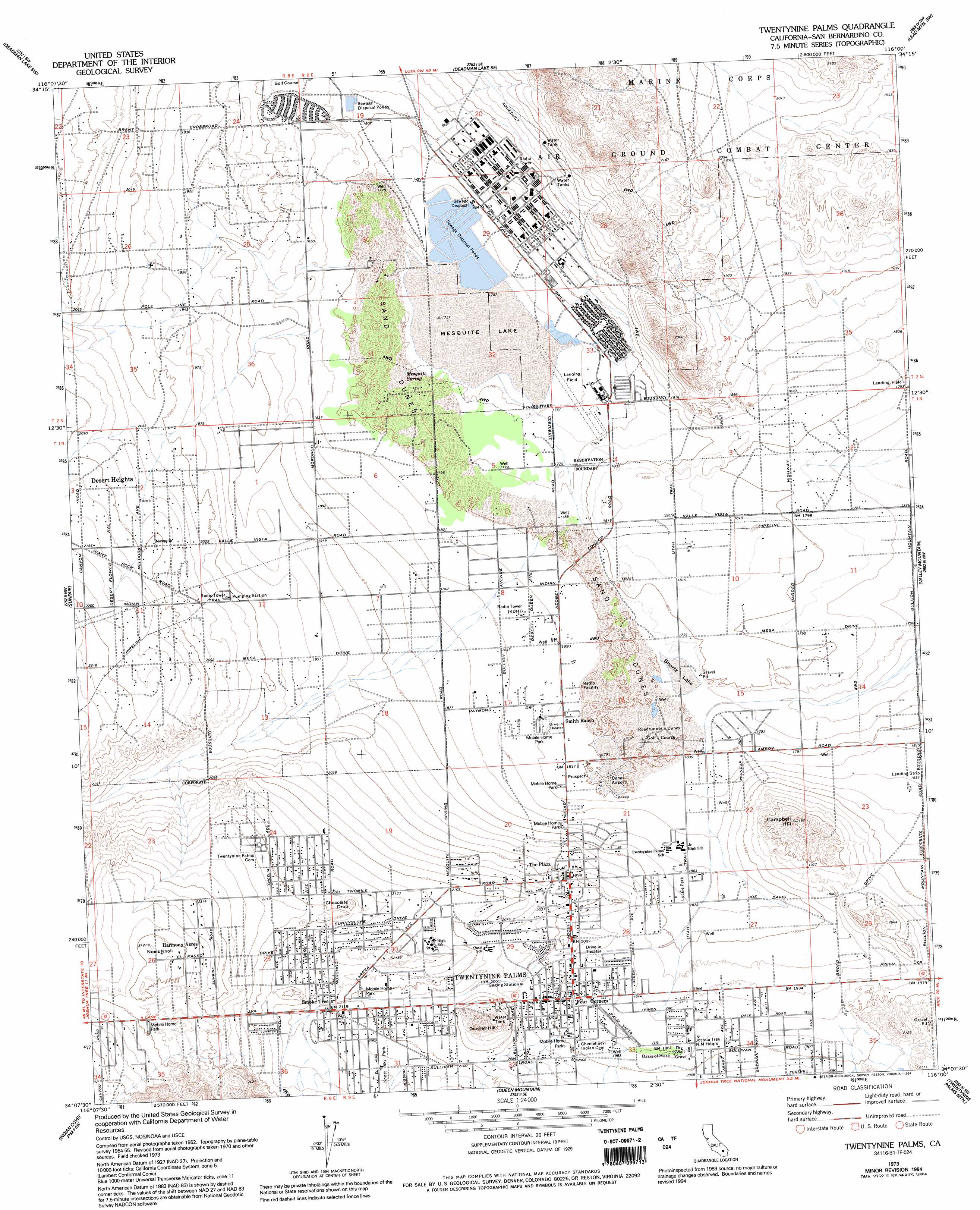
Twentynine Palms Topo Map California
To zoom in, hover over the map of Twentynine Palms
USGS Topo Quad 34116b1 - 1:24,000 scale
| Topo Map Name: | Twentynine Palms |
| USGS Topo Quad ID: | 34116b1 |
| Print Size: | ca. 21 1/4" wide x 27" high |
| Southeast Coordinates: | 34.125° N latitude / 116° W longitude |
| Map Center Coordinates: | 34.1875° N latitude / 116.0625° W longitude |
| U.S. State: | CA |
| Filename: | o34116b1.jpg |
| Download Map JPG Image: | Twentynine Palms topo map 1:24,000 scale |
| Map Type: | Topographic |
| Topo Series: | 7.5´ |
| Map Scale: | 1:24,000 |
| Source of Map Images: | United States Geological Survey (USGS) |
| Alternate Map Versions: |
Twentynine Palms CA 1955, updated 1956 Download PDF Buy paper map Twentynine Palms CA 1955, updated 1964 Download PDF Buy paper map Twentynine Palms CA 1973, updated 1975 Download PDF Buy paper map Twentynine Palms CA 1973, updated 1994 Download PDF Buy paper map Twentynine Palms CA 2012 Download PDF Buy paper map Twentynine Palms CA 2015 Download PDF Buy paper map |
1:24,000 Topo Quads surrounding Twentynine Palms
Hidalgo Mountain |
Deadman Lake Nw |
Deadman Lake Ne |
Lead Mountain |
Lead Mountain Ne |
Goat Mountain |
Deadman Lake Sw |
Deadman Lake Se |
Lead Mountain Sw |
Cleghorn Lakes |
Joshua Tree North |
Sunfair |
Twentynine Palms |
Valley Mountain |
East Of Valley Mountain |
Joshua Tree South |
Indian Cove |
Queen Mountain |
Twentynine Palms Mountain |
Humbug Mountain |
East Deception Canyon |
Keys View |
Malapai Hill |
Fried Liver Wash |
Pinto Mountain |
> Back to 34116a1 at 1:100,000 scale
> Back to 34116a1 at 1:250,000 scale
> Back to U.S. Topo Maps home
Twentynine Palms topo map: Gazetteer
Twentynine Palms: Airports
Cones Field elevation 549m 1801′Knott Sky Park elevation 649m 2129′
Twentynine Palms: Flats
Mesquite Lake elevation 536m 1758′Twentynine Palms: Populated Places
Harmony Acres elevation 723m 2372′Smoke Tree elevation 646m 2119′
The Plaza elevation 614m 2014′
Twentynine Palms elevation 606m 1988′
Twentynine Palms: Post Offices
Twentynine Palms Post Office elevation 603m 1978′Twentynine Palms: Springs
Oasis of Mara elevation 600m 1968′Twentynine Palms digital topo map on disk
Buy this Twentynine Palms topo map showing relief, roads, GPS coordinates and other geographical features, as a high-resolution digital map file on DVD: