Yucca Valley North Topo Map California
To zoom in, hover over the map of Yucca Valley North
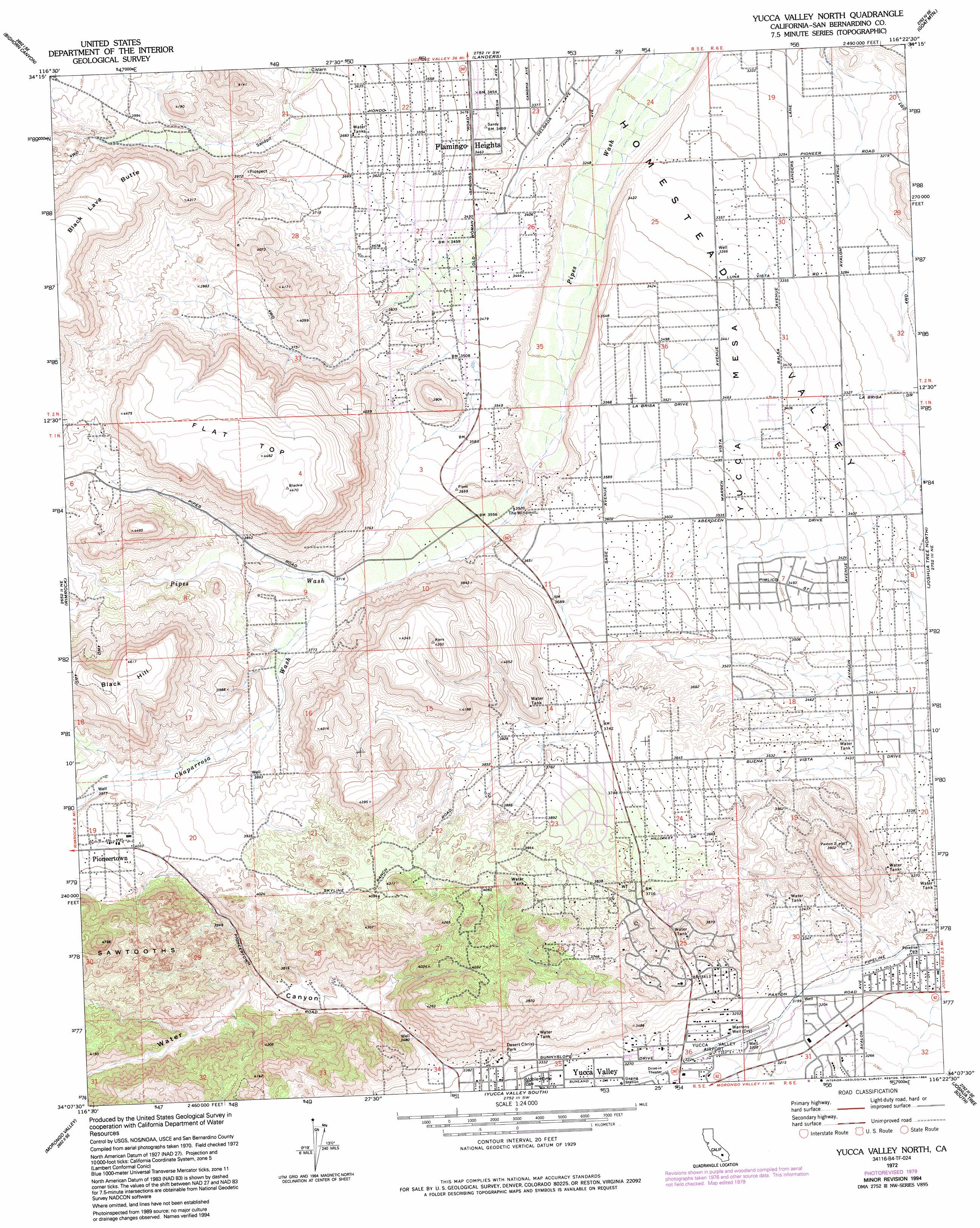
USGS Topo Quad 34116b4 - 1:24,000 scale
| Topo Map Name: | Yucca Valley North |
| USGS Topo Quad ID: | 34116b4 |
| Print Size: | ca. 21 1/4" wide x 27" high |
| Southeast Coordinates: | 34.125° N latitude / 116.375° W longitude |
| Map Center Coordinates: | 34.1875° N latitude / 116.4375° W longitude |
| U.S. State: | CA |
| Filename: | o34116b4.jpg |
| Download Map JPG Image: | Yucca Valley North topo map 1:24,000 scale |
| Map Type: | Topographic |
| Topo Series: | 7.5´ |
| Map Scale: | 1:24,000 |
| Source of Map Images: | United States Geological Survey (USGS) |
| Alternate Map Versions: |
Yucca Valley North CA 1972, updated 1975 Download PDF Buy paper map Yucca Valley North CA 1972, updated 1979 Download PDF Buy paper map Yucca Valley North CA 1972, updated 1986 Download PDF Buy paper map Yucca Valley North CA 1972, updated 1994 Download PDF Buy paper map Yucca Valley North CA 2012 Download PDF Buy paper map Yucca Valley North CA 2015 Download PDF Buy paper map |
1:24,000 Topo Quads surrounding Yucca Valley North
Old Woman Springs |
Melville Lake |
Emerson Lake |
Hidalgo Mountain |
Deadman Lake Nw |
Rattlesnake Canyon |
Bighorn Canyon |
Landers |
Goat Mountain |
Deadman Lake Sw |
Onyx Peak |
Rimrock |
Yucca Valley North |
Joshua Tree North |
Sunfair |
Catclaw Flat |
Morongo Valley |
Yucca Valley South |
Joshua Tree South |
Indian Cove |
White Water |
Desert Hot Springs |
Seven Palms Valley |
East Deception Canyon |
Keys View |
> Back to 34116a1 at 1:100,000 scale
> Back to 34116a1 at 1:250,000 scale
> Back to U.S. Topo Maps home
Yucca Valley North topo map: Gazetteer
Yucca Valley North: Airports
Yucca Valley Airport elevation 983m 3225′Yucca Valley Service Center Heliport elevation 987m 3238′
Yucca Valley North: Parks
Desert Christ Park elevation 1022m 3353′Golden Rule Park elevation 1033m 3389′
Paradise Park elevation 960m 3149′
Yucca Valley North: Populated Places
Flamingo Heights elevation 1057m 3467′Pioneertown elevation 1236m 4055′
Yucca Valley North: Post Offices
Pioneertown Post Office elevation 1240m 4068′Yucca Valley North: Streams
Chaparrosa Wash elevation 1123m 3684′Yucca Valley North: Summits
Black Hill elevation 1409m 4622′Flat Top elevation 1365m 4478′
Yucca Mesa elevation 1052m 3451′
Yucca Valley North: Valleys
Water Canyon elevation 1042m 3418′Yucca Valley North: Wells
Warrens Well elevation 978m 3208′Yucca Valley North digital topo map on disk
Buy this Yucca Valley North topo map showing relief, roads, GPS coordinates and other geographical features, as a high-resolution digital map file on DVD: