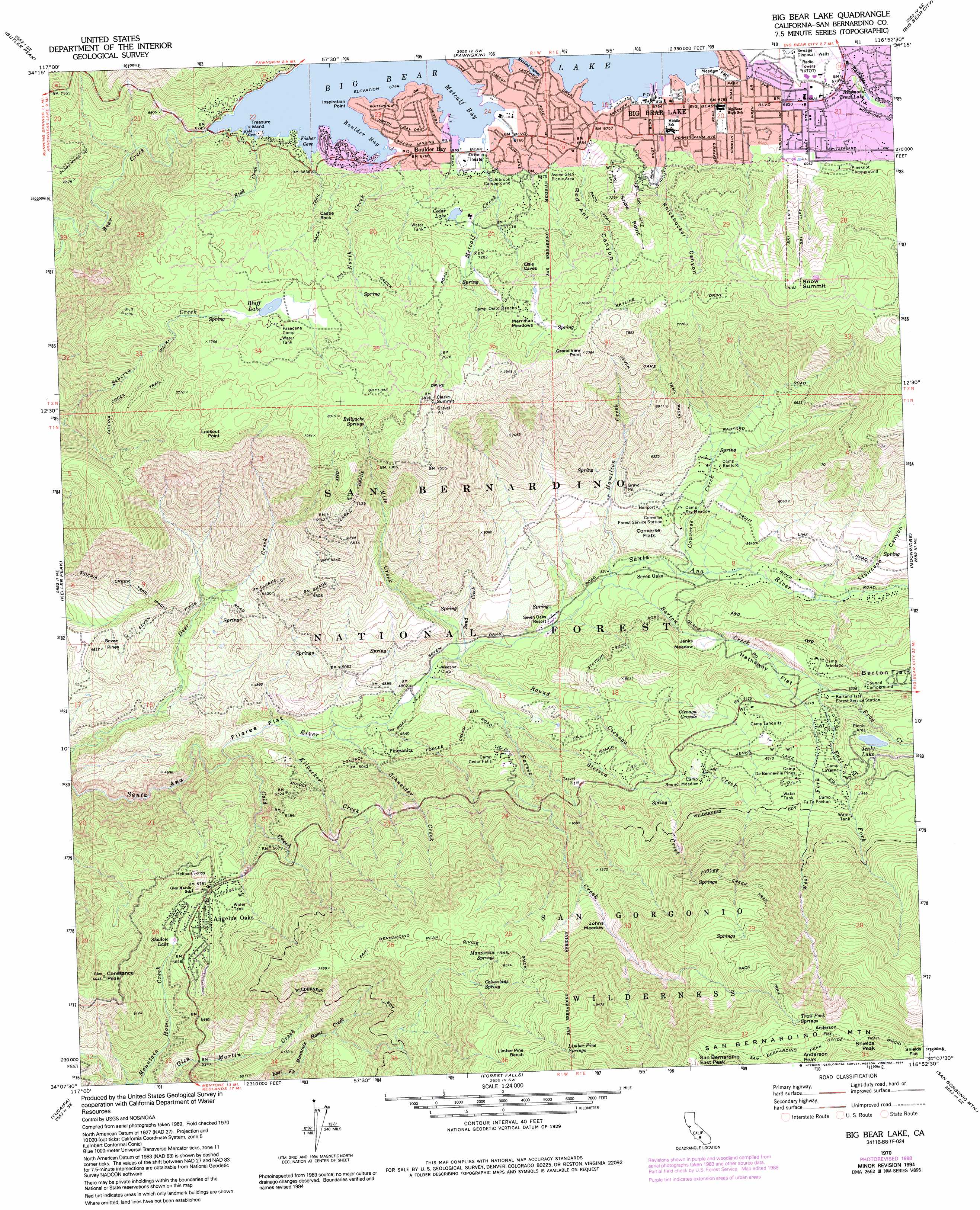
Big Bear Lake Topo Map California
To zoom in, hover over the map of Big Bear Lake
USGS Topo Quad 34116b8 - 1:24,000 scale
| Topo Map Name: | Big Bear Lake |
| USGS Topo Quad ID: | 34116b8 |
| Print Size: | ca. 21 1/4" wide x 27" high |
| Southeast Coordinates: | 34.125° N latitude / 116.875° W longitude |
| Map Center Coordinates: | 34.1875° N latitude / 116.9375° W longitude |
| U.S. State: | CA |
| Filename: | o34116b8.jpg |
| Download Map JPG Image: | Big Bear Lake topo map 1:24,000 scale |
| Map Type: | Topographic |
| Topo Series: | 7.5´ |
| Map Scale: | 1:24,000 |
| Source of Map Images: | United States Geological Survey (USGS) |
| Alternate Map Versions: |
Big Bear Lake CA 1970, updated 1975 Download PDF Buy paper map Big Bear Lake CA 1970, updated 1975 Download PDF Buy paper map Big Bear Lake CA 1970, updated 1984 Download PDF Buy paper map Big Bear Lake CA 1970, updated 1988 Download PDF Buy paper map Big Bear Lake CA 1970, updated 1993 Download PDF Buy paper map Big Bear Lake CA 1970, updated 1994 Download PDF Buy paper map Big Bear Lake CA 1996, updated 1999 Download PDF Buy paper map Big Bear Lake CA 2012 Download PDF Buy paper map Big Bear Lake CA 2015 Download PDF Buy paper map |
| FStopo: | US Forest Service topo Big Bear Lake is available: Download FStopo PDF Download FStopo TIF |
1:24,000 Topo Quads surrounding Big Bear Lake
Apple Valley South |
Fifteenmile Valley |
Lucerne Valley |
Cougar Buttes |
Old Woman Springs |
Lake Arrowhead |
Butler Peak |
Fawnskin |
Big Bear City |
Rattlesnake Canyon |
Harrison Mountain |
Keller Peak |
Big Bear Lake |
Moonridge |
Onyx Peak |
Redlands |
Yucaipa |
Forest Falls |
San Gorgonio Mountain |
Catclaw Flat |
Sunnymead |
El Casco |
Beaumont |
Cabazon |
White Water |
> Back to 34116a1 at 1:100,000 scale
> Back to 34116a1 at 1:250,000 scale
> Back to U.S. Topo Maps home
Big Bear Lake topo map: Gazetteer
Big Bear Lake: Bays
Boulder Bay elevation 2057m 6748′Fisher Cove elevation 2057m 6748′
Kidd Cove elevation 2057m 6748′
Mallard Lagoon elevation 2062m 6765′
Metcalf Bay elevation 2057m 6748′
Big Bear Lake: Benches
Limber Pine Bench elevation 2844m 9330′Big Bear Lake: Capes
Gibralter Point elevation 2057m 6748′Inspiration Point elevation 2064m 6771′
Big Bear Lake: Dams
Bear Valley 2015 Dam elevation 2040m 6692′Big Bear Dam elevation 2057m 6748′
Cedar Lake 802 Dam elevation 2161m 7089′
Glen Martin 800 Dam elevation 1702m 5583′
Big Bear Lake: Flats
Anderson Flat elevation 3223m 10574′Converse Flats elevation 1682m 5518′
Filaree Flat elevation 1366m 4481′
Hathaway Flat elevation 1857m 6092′
Jenks Meadow elevation 1754m 5754′
Johns Meadow elevation 2301m 7549′
Merriman Meadows elevation 2306m 7565′
Shields Flat elevation 3174m 10413′
Big Bear Lake: Forests
San Bernardino National Forest elevation 1832m 6010′Big Bear Lake: Gaps
Clarks Summit elevation 2377m 7798′Big Bear Lake: Islands
Treasure Island elevation 2057m 6748′Big Bear Lake: Lakes
Jenks Lake elevation 2054m 6738′Big Bear Lake: Parks
Aspen Glen Picnic Area elevation 2097m 6879′Barton Flats Recreation Area elevation 2050m 6725′
Jenks Lake Junction Recreation Area elevation 1967m 6453′
Meadow Park elevation 2060m 6758′
Big Bear Lake: Populated Places
Angelus Oaks elevation 1755m 5757′Big Bear Lake elevation 2058m 6751′
Boulder Bay elevation 2066m 6778′
Glen Martin elevation 1713m 5620′
Pinezanita elevation 1500m 4921′
Seven Oaks elevation 1617m 5305′
The Pines (historical) elevation 1643m 5390′
Big Bear Lake: Post Offices
Angelus Oaks Post Office elevation 1768m 5800′Big Bear Lake Post Office elevation 2058m 6751′
Big Bear Lake: Ranges
San Bernardino Mountains elevation 3164m 10380′Big Bear Lake: Reservoirs
Big Bear Lake elevation 2057m 6748′Bluff Lake elevation 2311m 7582′
Cedar Lake elevation 2157m 7076′
Shadow Lake elevation 1687m 5534′
Simmons Trout Lake elevation 2079m 6820′
Big Bear Lake: Springs
Bellyache Springs elevation 2358m 7736′Columbine Spring elevation 2447m 8028′
Limber Pine Springs elevation 2915m 9563′
Limber Pine Springs elevation 2639m 8658′
Manzanita Springs elevation 2524m 8280′
Trail Fork Springs elevation 3159m 10364′
Big Bear Lake: Streams
Barton Creek elevation 1582m 5190′Cold Creek elevation 1341m 4399′
Converse Creek elevation 1631m 5351′
East Fork Barton Creek elevation 1822m 5977′
Forsee Creek elevation 1474m 4835′
Frog Creek elevation 1907m 6256′
Hamilton Creek elevation 1591m 5219′
Kidd Creek elevation 2058m 6751′
Kilpecker Creek elevation 1374m 4507′
Metcalf Creek elevation 2058m 6751′
Mile Creek elevation 1495m 4904′
North Creek elevation 2057m 6748′
Round Cienaga Creek elevation 1495m 4904′
Sand Creek elevation 1499m 4917′
Schneider Creek elevation 1402m 4599′
Stetson Creek elevation 1593m 5226′
West Fork Barton Creek elevation 1822m 5977′
Big Bear Lake: Summits
Castle Rock elevation 2247m 7372′Constance Peak elevation 2021m 6630′
Grand View Point elevation 2357m 7732′
Lookout Point elevation 2413m 7916′
Seven Pines elevation 1468m 4816′
Shields Peak elevation 3261m 10698′
Snow Summit elevation 2491m 8172′
Big Bear Lake: Swamps
Cienaga Grande elevation 1911m 6269′Big Bear Lake: Trails
Forsee Creek Trail elevation 2662m 8733′San Bernardino Peak Divide Trail elevation 3246m 10649′
Seven Oaks Trail elevation 2130m 6988′
Big Bear Lake: Valleys
Red Ant Canyon elevation 2061m 6761′Snow Point Canyon elevation 2074m 6804′
Staircase Canyon elevation 1720m 5643′
Big Bear Lake digital topo map on disk
Buy this Big Bear Lake topo map showing relief, roads, GPS coordinates and other geographical features, as a high-resolution digital map file on DVD: