Landers Topo Map California
To zoom in, hover over the map of Landers
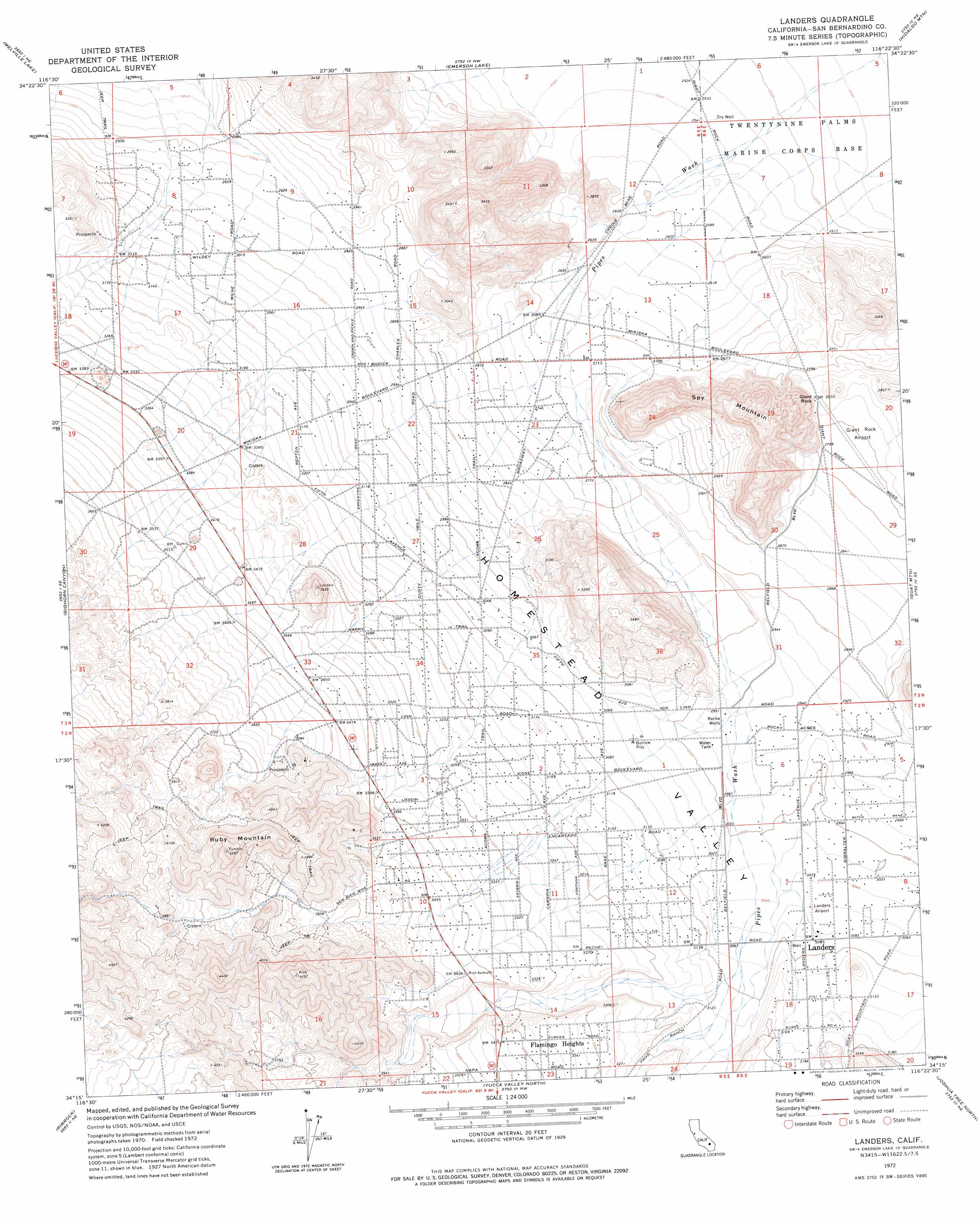
USGS Topo Quad 34116c4 - 1:24,000 scale
| Topo Map Name: | Landers |
| USGS Topo Quad ID: | 34116c4 |
| Print Size: | ca. 21 1/4" wide x 27" high |
| Southeast Coordinates: | 34.25° N latitude / 116.375° W longitude |
| Map Center Coordinates: | 34.3125° N latitude / 116.4375° W longitude |
| U.S. State: | CA |
| Filename: | o34116c4.jpg |
| Download Map JPG Image: | Landers topo map 1:24,000 scale |
| Map Type: | Topographic |
| Topo Series: | 7.5´ |
| Map Scale: | 1:24,000 |
| Source of Map Images: | United States Geological Survey (USGS) |
| Alternate Map Versions: |
Landers CA 1972, updated 1976 Download PDF Buy paper map Landers CA 1972, updated 1976 Download PDF Buy paper map Landers CA 2012 Download PDF Buy paper map Landers CA 2015 Download PDF Buy paper map |
1:24,000 Topo Quads surrounding Landers
Fry Mountains |
Iron Ridge |
Galway Lake |
Lavic Se |
Morgans Well |
Old Woman Springs |
Melville Lake |
Emerson Lake |
Hidalgo Mountain |
Deadman Lake Nw |
Rattlesnake Canyon |
Bighorn Canyon |
Landers |
Goat Mountain |
Deadman Lake Sw |
Onyx Peak |
Rimrock |
Yucca Valley North |
Joshua Tree North |
Sunfair |
Catclaw Flat |
Morongo Valley |
Yucca Valley South |
Joshua Tree South |
Indian Cove |
> Back to 34116a1 at 1:100,000 scale
> Back to 34116a1 at 1:250,000 scale
> Back to U.S. Topo Maps home
Landers topo map: Gazetteer
Landers: Airports
Landers Airport elevation 933m 3061′Landers: Pillars
Giant Rock elevation 866m 2841′Landers: Populated Places
Landers elevation 940m 3083′Landers: Post Offices
Landers Post Office elevation 941m 3087′Landers: Ridges
Spy Mountain elevation 1051m 3448′Landers: Summits
Ruby Mountain elevation 1322m 4337′Landers: Valleys
Homestead Valley elevation 978m 3208′Landers: Wells
Reche Wells elevation 899m 2949′Landers digital topo map on disk
Buy this Landers topo map showing relief, roads, GPS coordinates and other geographical features, as a high-resolution digital map file on DVD: